MyTopo
Manchester Islands Kentucky US Topo Map
Couldn't load pickup availability
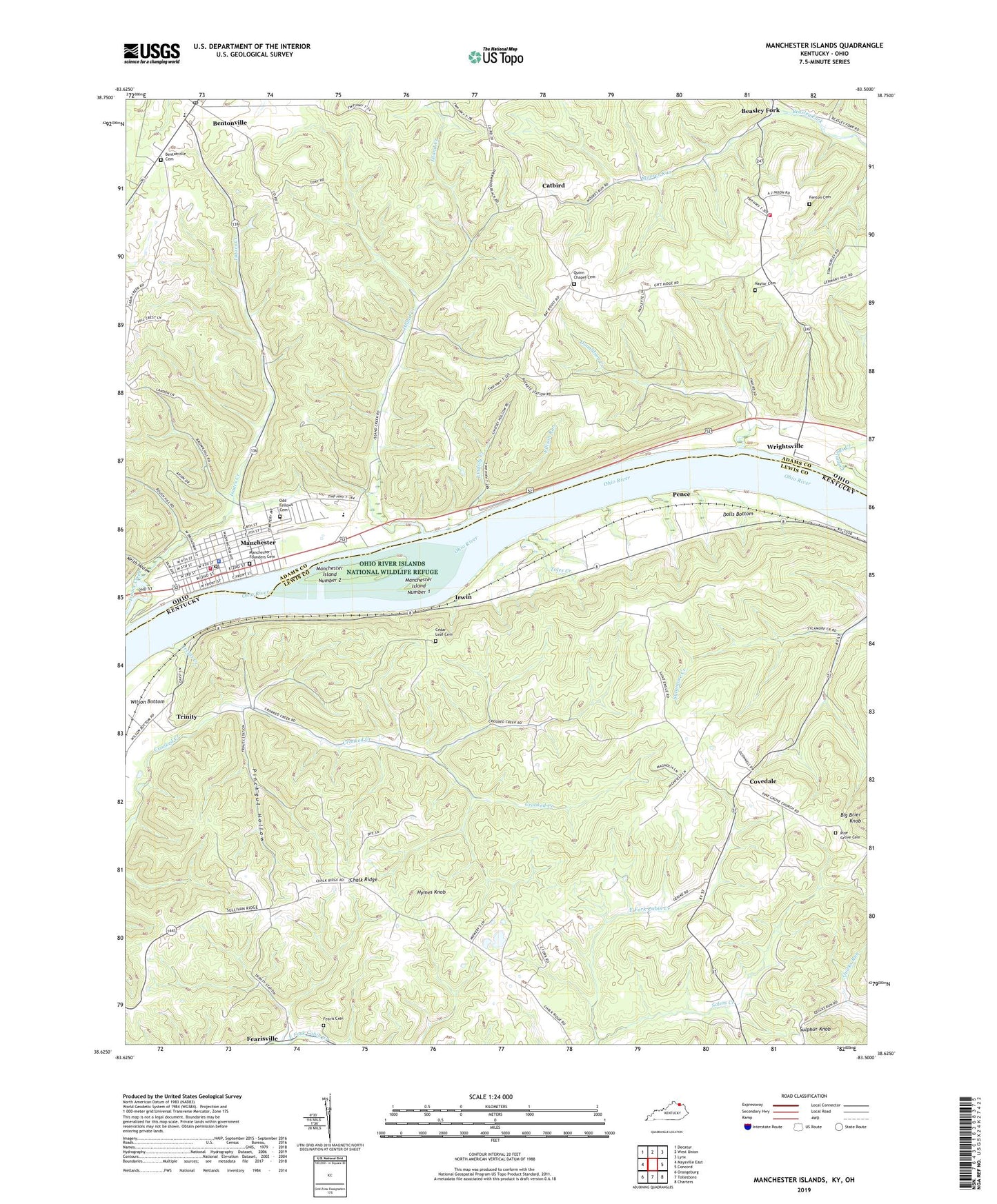
2022 topographic map quadrangle Manchester Islands in the states of Kentucky, Ohio. Scale: 1:24000. Based on the newly updated USGS 7.5' US Topo map series, this map is in the following counties: Lewis, Adams. The map contains contour data, water features, and other items you are used to seeing on USGS maps, but also has updated roads and other features. This is the next generation of topographic maps. Printed on high-quality waterproof paper with UV fade-resistant inks.
Quads adjacent to this one:
West: Maysville East
Northwest: Decatur
North: West Union
Northeast: Lynx
East: Concord
Southeast: Charters
South: Tollesboro
Southwest: Orangeburg
Contains the following named places: Alburn Post Office, Beasley Fork, Beasleys Fork Post Office, Bentonville, Bentonville Cemetery, Bentonville Census Designated Place, Bentonville Church, Bentonville Elementary School, Big Brier Knob, Catbird, Catbird School, Cedar Leaf Cemetery, Centenary Methodist Episcopal Church, Chalk Ridge, Chalk Ridge School, Church of the Nazarene, Covedale, Covedale Post Office, Covedale School, Dolls Bottom, Donaldson Creek, East Fork Church, Ellison Run, Fearis Cemetery, Fearisville, Fearsville Post Office, Fenton Cemetery, Fenton School, First Methodist Protestant Church, First Presbyterian Church, Fryer School, Fryes Church, Gilpins Landing, Hildebrand Hollow, Hoop School, Hymes Knob, Irvin Railroad Station, Irvins Creek, Irwin, Island Creek, Island Creek Boat Launch Ramp, Island Creek Church, Island Creek School, Keith Hollow, Leonards Chapel, Lindsey Creek, Manchester, Manchester Boat Launch Ramp, Manchester City Hall, Manchester Fire Department, Manchester Founders Cemetery, Manchester High School, Manchester Island Number 1, Manchester Island Number 2, Manchester Life Squad, Manchester Police Department, Manchester Post Office, Manchester Station Landing, Monroe Township Volunteer Fire Department Station 14, Moores Run, Odd Fellows Cemetery, Ohio River Islands National Wildlife Refuge, Ohio Valley District Free Public Library, Osman School, Pence, Pence Run, Pence School, Pentecostal Church, Pinchgut Hollow, Pine Grove Cemetery, Pine Grove Church, Quicks Run Light, Quinn Chapel, Quinn Chapel Cemetery, R O Cabin Railroad Station, Reed Cemetery, Saint Marys Roman Catholic Church, Salem Creek, Sand Hill Church, Scott School, Sulphur Knob, Toles Creek, Township of Manchester, Township of Monroe, Trinity, Trinity Church, Trinity Post Office, Trinity Railroad Station, Trinity School, Twin Islands Campground, Village of Manchester, Wells Landing, Wesley Chapel, Williamson Hollow, Wilson Bottom, Woolard Elementary School, Wrightsville, ZIP Code: 45144