MyTopo
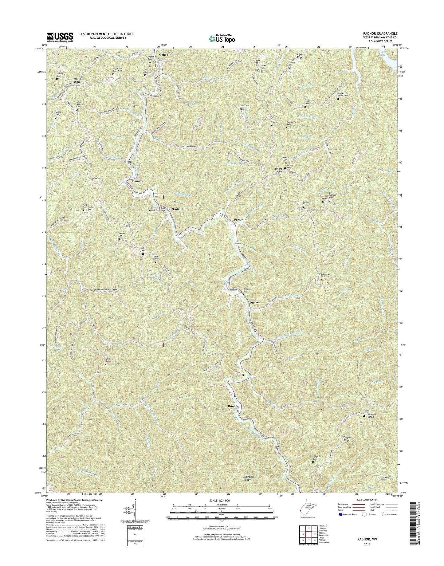
Radnor West Virginia US Topo Map
Couldn't load pickup availability
2023 topographic map quadrangle Radnor in the state of West Virginia. Scale: 1:24000. Based on the newly updated USGS 7.5' US Topo map series, this map is in the following counties: Wayne. The map contains contour data, water features, and other items you are used to seeing on USGS maps, but also has updated roads and other features. This is the next generation of topographic maps. Printed on high-quality waterproof paper with UV fade-resistant inks.
Quads adjacent to this one:
West: Louisa
Northwest: Prichard
North: Wayne
Northeast: Nestlow
East: Kiahsville
Southeast: Wilsondale
South: Webb
Southwest: Milo
This map covers the same area as the classic USGS quad with code o38082a4.
Contains the following named places: Amp Branch, Apple Orchard Branch, Bearwallow Branch, Bethel Church, Big Branch, Billy Branch, Billy Branch School, Bob Wetherall Branch, Cassidy Cemetery, Cox Cemetery, Damel Fork, Damron Cemetery, Damron School, Dan Wallace Cemetery, Dick Branch, Donathan Branch, Drift Branch, Dunlow, Dunlow Elementary School, Dunlow Post Office, Dunlow Volunteer Fire Department and Rescue, Everett Dillon Memorial Bridge, Fairmont Church, Ferguson, Ferguson Branch, Ferguson Cemetery, Ferguson Ridge, Flat Branch, Fleming, Geiger Branch, Genoa, Genoa Post Office, Grassy Branch, Haney Church, Haney School, Harless Cemetery, Henry Smith Branch, Hickory Gap, Holly Branch, Hooker Cemetery, Hooker Knob, Humpy Branch, Hurricane Branch, Jackson Branch, Jackson Cemetery, John Napier Cemetery, John Robertson Cemetery, Justice Cemetery, Laurel Fork, Left Fork Rich Creek, Left Fork Sycamore Branch, Licklog Branch, Little Spring Branch, Lost Creek Church, Lower Napier Cemetery, Lycans Cemetery, Lycans Ridge, Lycans Ridge School, Lynn Fork, Marilyn Napier Cemetery, Martha Noe Branch, Mat Rice Branch, Matthews Cemetery, Matty Ferguson Branch, May Branch, Mill Creek Church, Napier Cemetery, Napier Ridge, Noe Cemetery, Perry Memorial Church, Porter Cemetery, Pratt Cemetery, Preston Cemetery, Quaker, Radnor, Rich Creek School, Right Fork Lost Creek, Right Fork Rich Creek, Robertson Cemetery, Rockhouse Fork, Sally Branch, Sam Noe Branch, Sandlick Branch, Smith Cemetery, Spence Cemetery, Spruce Fork, Stiltner Cemetery, Stonecoal Branch, Sycamore Branch, Thompson Cemetery, Upper Napier Cemetery, Watts and Perry Cemetery, Watts Ridge, Wilson Cemetery, Wolfpen Branch, Workman Cemetery, Zion Church, ZIP Code: 25517