MyTopo
Webb West Virginia US Topo Map
Couldn't load pickup availability
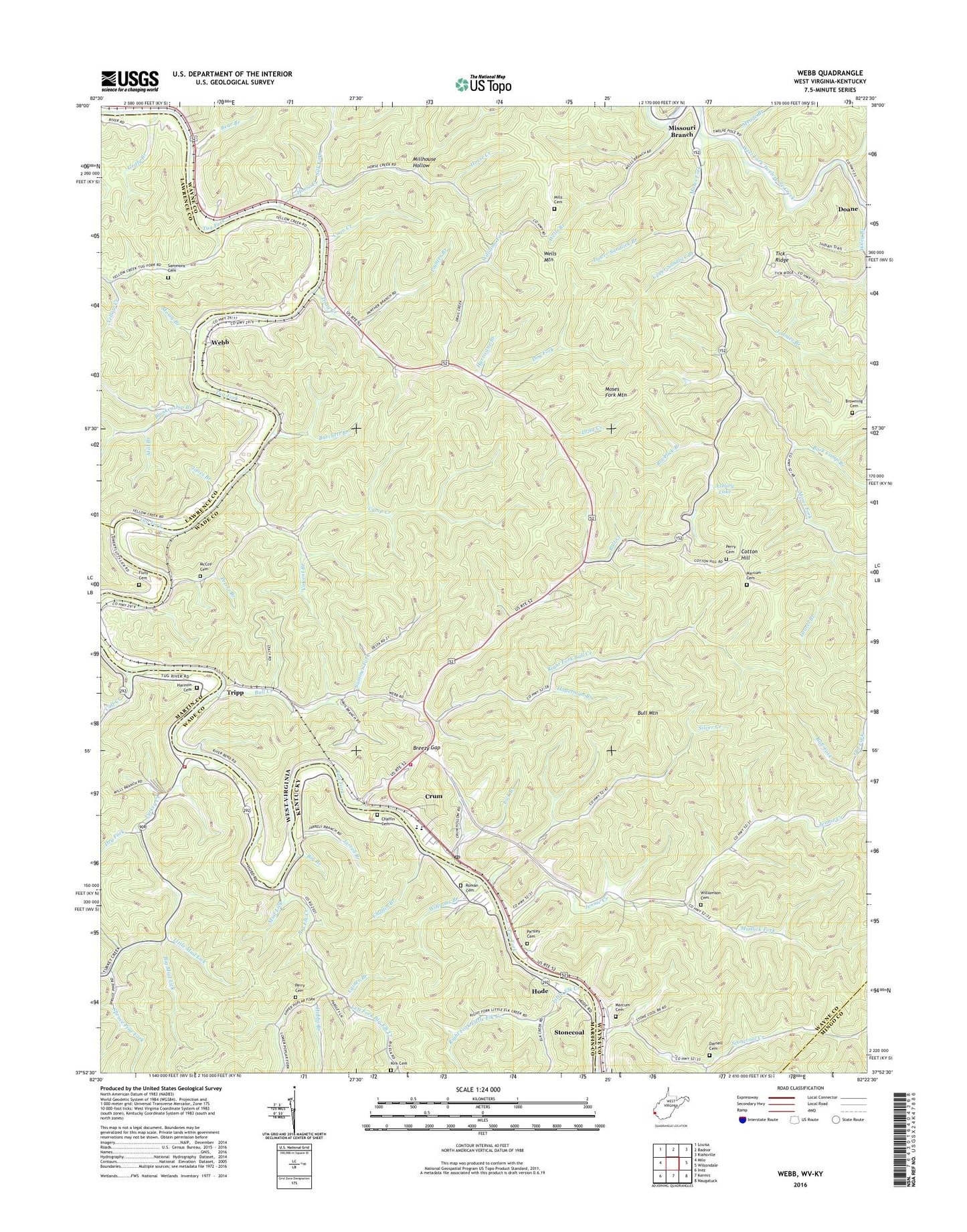
2023 topographic map quadrangle Webb in the states of West Virginia, Kentucky. Scale: 1:24000. Based on the newly updated USGS 7.5' US Topo map series, this map is in the following counties: Wayne, Martin, Lawrence, Mingo. The map contains contour data, water features, and other items you are used to seeing on USGS maps, but also has updated roads and other features. This is the next generation of topographic maps. Printed on high-quality waterproof paper with UV fade-resistant inks.
Quads adjacent to this one:
West: Milo
Northwest: Louisa
North: Radnor
Northeast: Kiahsville
East: Wilsondale
Southeast: Naugatuck
South: Kermit
Southwest: Inez
This map covers the same area as the classic USGS quad with code o37082h4.
Contains the following named places: Arkansas Branch, Asbury Lake, Baker Gap School, Bark Camp Branch, Bear Branch, Big Branch, Big Elk Creek, Big Elk Old Zion United Baptist Church, Big Mud Lick, Blankenship Branch, Breezy Gap, Browning Cemetery, Bull Creek, Bull Creek Church, Bull Fork, Bull Mountain, Burchett Branch, Cainer Branch, Calf Creek, Camp Creek, Camp Creek School, Cassie Post Office, Chaffin Branch, Chaffin Cemetery, Concord Baptist Church, Coon Creek, Cotton Hill, Crum, Crum Census Designated Place, Crum Elementary School, Crum Middle School, Crum Post Office, Darnell Cemetery, Dog Fork, Drag Creek, Drag Creek School, Dry Fork, Fluty Cemetery, Griffy Branch, Hagerman Branch, Harmon Cemetery, Hobbs Branch, Hode, Horse Creek, Hurricane Branch, Jarrell Branch, Jennie Creek, Jones Branch, Jonnies Branch, Kermit Volunteer Fire Department Crum Station, Laurel Branch, Left Fork Big Elk Creek, Lick Branch, Little Elk Creek, Little Mud Lick, Lower Sandlick Branch, Marcum Cemetery, McCoy Cemetery, Meade Branch, Mill Branch, Millet, Millhouse Hollow, Mills Cemetery, Missouri Branch, Moses Fork, Moses Fork Church, Moses Fork Mountain, Mossy Branch, Mothers United Church, Mud Lick, Mudlick Fork, Old Fork, Osborne Cemetery, Painter Branch, Parsley Cemetery, Perry Cemetery, Peters Branch, Pine Grove Church, Right Fork Bull Creek, Right Fork Little Elk Creek, Right Fork Moses Fork, Right Fork Stonecoal Creek, Roberts Branch, Rocklick Branch, Roman Cemetery, Sammons Cemetery, Shirttail Fork, Silk Fork, Silver Creek, Spruce Pine Fork, Stonecoal, Stonecoal Creek, Stonecoal School, Stoney Hill Church, Summer Fork, Temple Bell Church, Thomas Copley Church, Tick Ridge, Tick Ridge Lookout Tower, Tripp, Turkey Creek, Turkey Creek Church, Turkey Creek School, Turkey Creek Volunteer Fire Department, Upper Sandlick Branch, Upper Tug, Upper Tug School, Vincent Branch, Walnut Grove Church, Walnut Grove School, Webb, Wells Branch, Wells Mountain, Williams Branch, Williams Fork, Williamson Cemetery, ZIP Codes: 25669, 41267