MyTopo
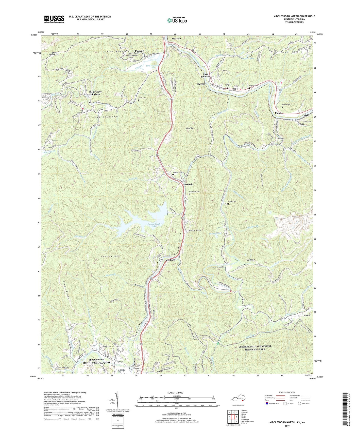
Middlesboro North Kentucky US Topo Map
Couldn't load pickup availability
2022 topographic map quadrangle Middlesboro North in the state of Kentucky. Scale: 1:24000. Based on the newly updated USGS 7.5' US Topo map series, this map is in the following counties: Bell, Lee. The map contains contour data, water features, and other items you are used to seeing on USGS maps, but also has updated roads and other features. This is the next generation of topographic maps. Printed on high-quality waterproof paper with UV fade-resistant inks.
Quads adjacent to this one:
West: Kayjay
Northwest: Artemus
North: Pineville
Northeast: Balkan
East: Varilla
Southeast: Wheeler
South: Middlesboro South
Southwest: Fork Ridge
Contains the following named places: Acosta Railroad Station, Amru Railroad Station, Bartleys Lake, Bear Wallow Gap, Bell County, Bell County Volunteer Fire Department Clear Creek Station, Bell County Volunteer Fire Department Colmar Station, Bell County Volunteer Fire Department Four Mile Station, Bell County Volunteer Fire Department Headquarters, Besson Railroad Station, Bills Branch, Bingham Cemetery, Binghamtown, Bird Branch, Blue Ridge Church, Bobs Hollow, Browne Branch, Calvin Church, Calvin Railroad Station, Cam Campbell Boy Scout Camp, Canada Mountain, Cannon Creek, Cannon Creek Lake, Carrigan Railroad Station, Clear Creek, Clear Creek Baptist Bible College, Clear Creek Railroad Station, Clear Creek School, Clear Creek Springs, Clear Fork, Clear Fork Church, Colmar, Colmar Railroad Station, Cranes Creek, Cross Railroad Station, Dark Ridge, East Pineville, Excelsior Mine, Excelsior Railroad Station, Falk Railroad Station, Ferndale, Ferndale Railroad Station, Flag Top, Flat Branch, Fourmile Run, Fuson Branch, Green Hills Memorial Gardens, Greene Cemetery, Harbell, Harbell Railroad Station, Harmony Church, Harmony Elementary School, Harmount Railroad Station, Hemlock Garden Picnic Area, Henderson Cemetery, Hurst Cemetery, Johnson Cemetery, Kelten Railroad Station, Kentucky Division of Forestry Southeastern District, Knuckle Cemetery, Knuckle Church, Korval Railroad Station, Lafontain Post Office, Laurel Branch, Laurel Cove Amphitheater, Laurel Hill, Laurel Hill Cemetery, Laurel Hill School, Laurel Lakes, Left Fork Williams Branch, Lick Fork, Little Clear Creek, Living Stairway, Logsen Railroad Station, Low Ash Hollow, Manito Church, Mansfield Railroad Station, Meldrum, Meldrum Railroad Station, Middlesborough Division, Moore Branch, Moss Chapel, Mount Mary Church, Old Cannon Creek Baptist Church, Page Railroad Station, Page School, Patterson Branch, Peavier Cemetery, Pine Mountain Lake, Pine Mountain Lodge, Pine Mountain State Resort Park, Ponza, Ponza Railroad Station, Red Oak Baptist Church, Right Fork Williams Branch, Rocky Face, Salem Number 2 Church, Shelton Branch, Shelton Cemetery, Slusher Cemetery, Smith Branch, Smith Cemetery, Stevenson Branch, Stillhouse Branch, Sugar Run, Taylors Cemetery, The Old Narrows, Trace Ridge, Turner Church, Turnhole Branch, Vogel Railroad Station, Ward Chapel School, Wasioto, Wasioto Church, Westcott Railroad Station, Wilder Cemetery, Williams Branch, WMIK-AM (Middlesboro), Yellow Branch, Yellow Creek, Yellow Creek Bypass, Yellow Creek Church, Yellow Creek Post Office, ZIP Code: 40965