MyTopo
Yosemite Kentucky US Topo Map
Couldn't load pickup availability
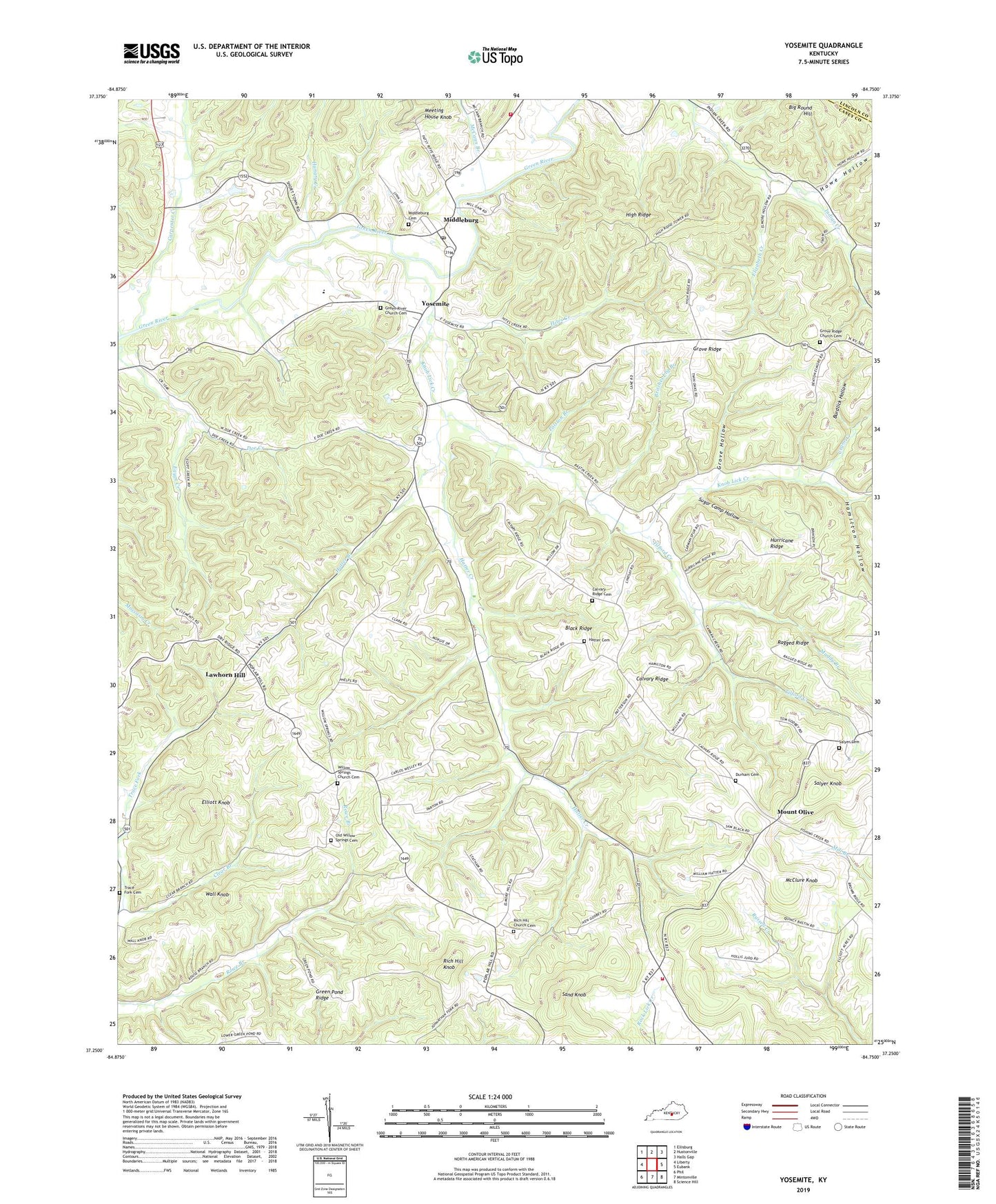
2022 topographic map quadrangle Yosemite in the state of Kentucky. Scale: 1:24000. Based on the newly updated USGS 7.5' US Topo map series, this map is in the following counties: Casey, Lincoln. The map contains contour data, water features, and other items you are used to seeing on USGS maps, but also has updated roads and other features. This is the next generation of topographic maps. Printed on high-quality waterproof paper with UV fade-resistant inks.
Quads adjacent to this one:
West: Liberty
Northwest: Ellisburg
North: Hustonville
Northeast: Halls Gap
East: Eubank
Southeast: Science Hill
South: Mintonville
Southwest: Phil
This map covers the same area as the classic USGS quad with code o37084c7.
Contains the following named places: Big Round Hill, Black Ridge, Britches Leg Branch, Burdlick Hollow, Calvary, Calvary Ridge, Calvary Ridge Cemetery, Calvary School, Carpenter Creek, Clear Branch, Crane Creek, Delk School, Durham Cemetery, Dye Post Office, East Casey Volunteer Fire Department, Egypt Creek, Elizabeth Creek, Elliott Knob, Freedom School, Green Pond Ridge, Green Pond School, Green River Christian Church, Green River Church Cemetery, Grove Church, Grove Hollow, Grove Post Office, Grove Ridge, Grove Ridge Baptist Church, Grove Ridge Church Cemetery, Grove School, Hamilton Hollow, Hartwell Post Office, Hatter Branch, Hatter Cemetery, Hatter Creek, Hatter Creek School, High Ridge, Hites Creek, Howe Hollow, Humphrey Post Office, Hungry Creek, Hurricane Meeting House, Hurricane Ridge, Indian Creek Baptist Church, Jasper Post Office, Judd Post Office, Knob Lick Creek, Knob Lick School, Lawhorn Hill, Lawhorn Hill School, McCann Branch, McClure Knob, Meeting House Knob, Middleburg, Middleburg Cemetery, Middleburg Division, Middleburg Post Office, Middleburg School, Moore Branch, Mount Calvary Baptist Church, Mount Olive, Mount Olive School, Muddy Branch, Old Willow Methodist Church, Old Willow Springs Cemetery, Pine Grove School, Polston Branch, Poplar Hill Post Office, Poplar Hill School, Ragged Ridge, Rich Hill Church, Rich Hill Church Cemetery, Rich Hill Knob, Salyer Cemetery, Salyer Knob, Sand Knob, Southeast Casey Volunteer Fire Department, Sugar Camp Hollow, Tilford Creek, Trace Fork Cemetery, Trace Fork Church, Vinson Post Office, Wa-kon-da-ho Camp, Wall Knob, Willow Springs Methodist Church, Willow Springs United Methodist Church Cemetery, Yosemite, Yosemite School, ZIP Codes: 40442, 42541, 42566