MyTopo
Reserve Louisiana US Topo Map
Couldn't load pickup availability
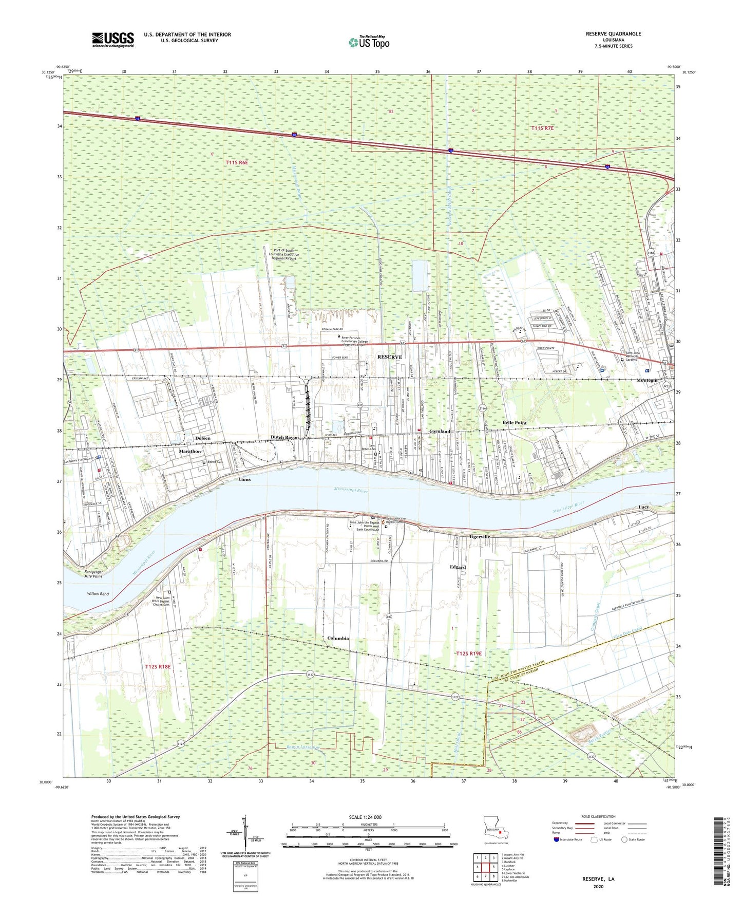
2020 topographic map quadrangle Reserve in the state of Louisiana. Scale: 1:24000. Based on the newly updated USGS 7.5' US Topo map series, this map is in the following counties: St. John the Baptist, St. Charles. The map contains contour data, water features, and other items you are used to seeing on USGS maps, but also has updated roads and other features. This is the next generation of topographic maps. Printed on high-quality waterproof paper with UV fade-resistant inks.
Quads adjacent to this one:
West: Lutcher
Northwest: Mount Airy NW
North: Mount Airy NE
Northeast: Ruddock
East: Laplace
Southeast: Hahnville
South: Lac des Allemands
Southwest: Lower Vacherie
Contains the following named places: Beechgrove Baptist Church, Belle Point, Belle Point Plantation, Bethlehem Baptist Church, Bishop Cemetery, Boonel Plantation, Bougere, Church of Christ, Church of God in Christ, Columbia, Columbia Plantation, Company Canal, Cooper Shop Landing, Cornland, Dolsen, Duke, Dutch Bayou, East Saint John Elementary School, East Saint John High School, Edgard, Edgard Census Designated Place, Edgard Landing, Edgard Post Office, Edgard Station, Fifth Ward Elementary School, First Baptist Church of Reserve, Fortyeight Mile Point, Garyville, Garyville Mount Airy Math and Science Magnet School, Garyville Volunteer Fire Department Station 71, Glen Dale Canal, Global Maritime Ministries, Godchaux Canal, Gold Mine Gas Field, Gold Mine Plantation, Greater Morning Star Baptist Church, Greater New Plymouth Rock Baptist Church, Haydel, Hope, Hope Plantation, La Place Post Office, Lace Sewage Treatment Plant, Leon Godchaux Alternative School, Lieutenant Sherman Walker Correctional Facility, Lions, Lucy, Lucy Revetment, Marathon, Moll Canal, Montegut, Mount Zion Baptist Church, New Hopeful Missionary Baptist Church, New Jerusalem Baptist Church, New Pilgrim Baptist Church, Ninde Chapel, Oschner Health Center - River Parishes Hospital, Our Lady of Grace Catholic School, Our Lady of Grace Church, Parish Governing Authority District 3, Parish Governing Authority District 4, Port of South Louisiana Executive Regional Airport, Rescue Mission Baptist Church, Reserve, Reserve Census Designated Place, Reserve Christian School, Reserve Church, Reserve Elementary School, Reserve Landing, Reserve Post Office, Reserve Relief Canal, Reserve Revetment, Reserve Station, Reserve Volunteer Fire Department Station 3, Reserve Volunteer Fire Department Station 61, Reserve Volunteer Fire Department Station 64, Reserve Volunteer Fire Department Station 65, Reserve-Edgard Ferry, River Parish Hospital Heliport, River Parishes Community College - Reserve Campus, Riverlands Christian Center, Riverside Academy School, Saint Hubert Church, Saint John Parish Child Development Center School, Saint John Parish Police Jury, Saint John Parish Sheriff's Office, Saint John Redirection Center School, Saint John the Baptist Catholic Church, Saint John the Baptist Cemetery, Saint John the Baptist Parish Health Unit, Saint John the Baptist Parish Library Edgard Branch, Saint John the Baptist Parish Library Garyville Branch, Saint John the Baptist Parish Library Reserve Branch, Saint John Westside Volunteer Fire Department, Saint John Westside Volunteer Fire Department Station 95, Saint Martins Church, Saint Peter Catholic Church, Saint Peter School - Reserve, Saint Peters Church, San Francisco Plantation, Second Ward School, Southeast Louisiana War Veterans Home, St John Parish Sheriff's Office Patrol Division, Sunnyside Plantation, Terre Haute Plantation, Tigerville, True Light Baptist Church, Wallace Post Office, Ward Five, Ward One, Ward Six, WCKW-AM (Garyville), Welcome, West Saint John Elementary School, West Saint John High School, Wheel Estates Mobile Home Park, White Rose Landing, Willow Bend, Willow Bend Revetment, ZIP Codes: 70049, 70084