MyTopo
Lutcher Louisiana US Topo Map
Couldn't load pickup availability
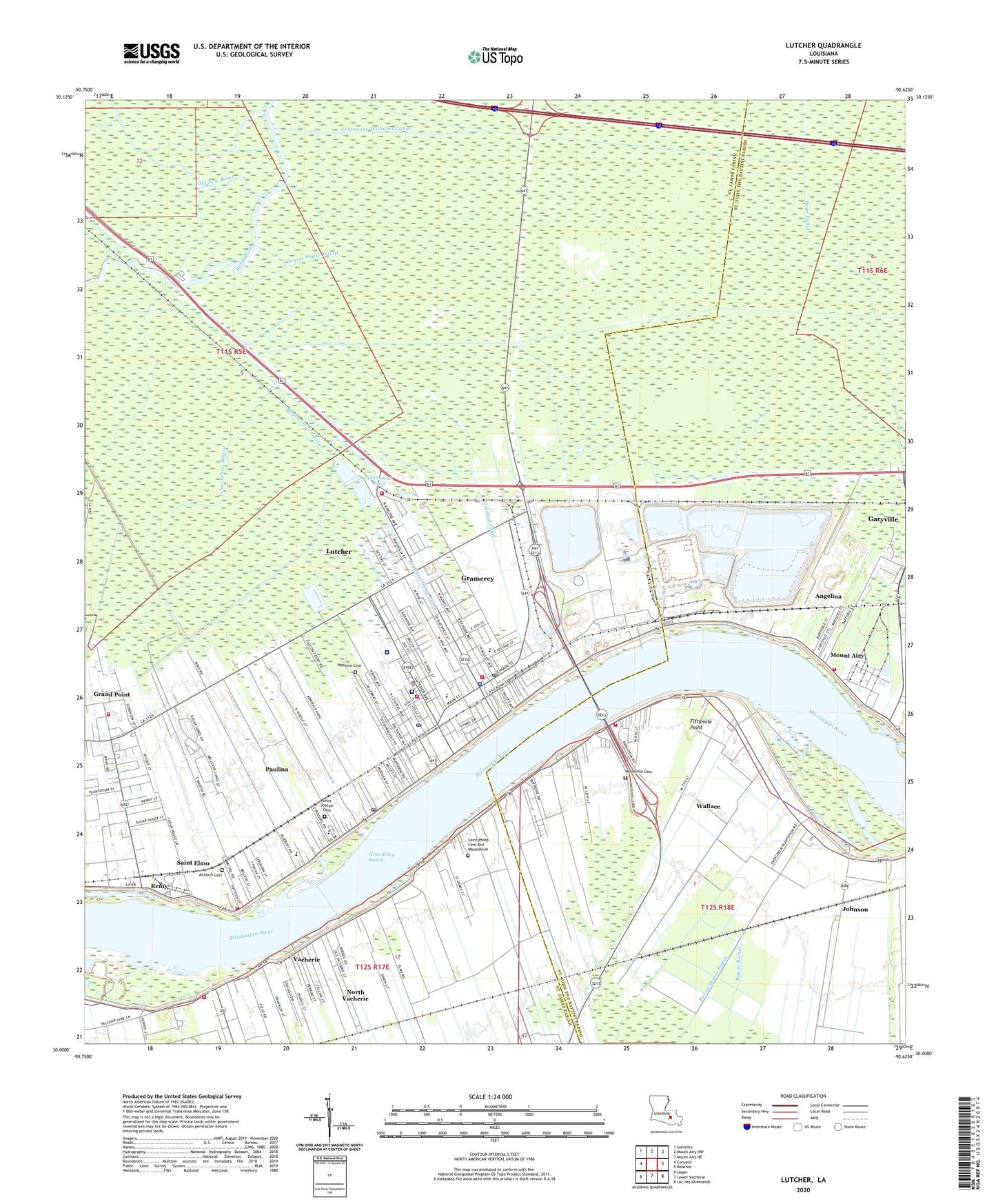
2024 topographic map quadrangle Lutcher in the state of Louisiana. Scale: 1:24000. Based on the newly updated USGS 7.5' US Topo map series, this map is in the following counties: St. James, St. John the Baptist. The map contains contour data, water features, and other items you are used to seeing on USGS maps, but also has updated roads and other features. This is the next generation of topographic maps. Printed on high-quality waterproof paper with UV fade-resistant inks.
Quads adjacent to this one:
West: Convent
Northwest: Sorrento
North: Mount Airy NW
Northeast: Mount Airy NE
East: Reserve
Southeast: Lac des Allemands
South: Lower Vacherie
Southwest: Lagan
This map covers the same area as the classic USGS quad with code o30090a6.
Contains the following named places: Angelina, Angelina Landing, Angelina Revetment, Antioch Cemetery, Armant Landing, Armant Plantation, Baptist Church, Bayou Andre David, Bayou Des Jones, Bayou La Trainasse, Bayou Shepherd, Beauvais Plantation, Bellevue Plantation, Bourbon Plantation, Bourgeoise Plantation, Carroll Plantation, Chapman Plantation, Colonial Canal, Crescent Landing, Crescent Plantation, Cress, Curtis Plantation, De Lobel Plantation, Dupare Plantation, Duprac Landing, Evergreen Plantation, Fiftymile Point, First Baptist Church of Vacherie, First Community Antioch Baptist Church, Garyville Census Designated Place, Garyville Volunteer Fire Department Station 72, Gramercy, Gramercy Elementary School, Gramercy Police Department, Gramercy Post Office, Gramercy Town Canal, Gramercy Volunteer Fire Department Station 1, Gramercy Volunteer Fire Department Station 2, Gramercy Volunteer Fire Department Station 3, Gramercy Wastewater Treatment Facility, Grand Point Census Designated Place, Grand View, Grandview Reach, Greater Golden Grove Baptist Church, Greater King Triumph Church, Hester Gas Field, Highway Baptist Church, Highway Baptist Church Day Care Center, Highway Church, Hope Canal, Israelite Baptist Church, Johnson, Jolly Plantation, King David Baptist Church, Kingdom Hall of Jehovahs Witnesses, Leche Plantation, Legendre Plantation, Longue Plantation, Lutcher, Lutcher Chapel United Methodist Church, Lutcher Elementary School, Lutcher Fire Department, Lutcher Head Start Center I School, Lutcher Head Start Center II School, Lutcher High School, Lutcher Junior High School, Lutcher Methodist Church, Lutcher Police Department, Lutcher Post Office, Lutcher Volunteer Fire Department, Lutcher-Cresent Ferry, Magnolia Landing, Magnolia Plantation, Magnolia School, Miles, Mount Airy, Mount Airy Landing, Mount Airy Plantation, Mount Airy Post Office, Mount Olive Baptist Church, New Zion Baptist Church, Norma Landing, Normal Landing, North Garyville Oil and Gas Field, North Vacherie Census Designated Place, Old New River, Oubre, Parish Governing Authority District 1, Parish Governing Authority District 2, Parish Governing Authority District 3, Paulina, Paulina - Grand Point - Belmont Fire Department Grand Point Station 10, Paulina - Grand Point - Belmont Fire Department Paulina Station, Paulina Census Designated Place, Paulina Elementary School, Paulina Post Office, Pilgrim Church, Prevailing Faith Ministries, Regina Plantation, Remy, Riverlands Health Care Center, Sacred Heart Church, Saint Elmo, Saint James Behavioral Health Hospital, Saint James Community Church, Saint James Culture and Heritage Center, Saint James Parish Hospital, Saint James Parish Library, Saint Joe Missionary Baptist Church, Saint John Baptist Church, Saint Joseph Cemetery, Saint Joseph Church, Saint Joseph Plantation, Saint Marks Church, Saint Martinville School, Saint Matthew Baptist Church, Saint Peter Chanel Interparochial School, Saint Philip Catholic Church, Saint Philip Cemetery and Mausoleum, Songy, Sport, Sport Plantation, Sportsman Pond, Tchackehou Bayou, Tennessee Williams Canal, The Greater Woodville Baptist Church, Town of Gramercy, Town of Lutcher, Vacherie, Vacherie Oil and Gas Field, Vacherie Revetment, Vacherie Volunteer Fire Department Station 1, Valcour Aime Plantation, Wags, Wallace, Wallace Census Designated Place, Ward One, Ward Three, Ward Two, West Saint John Fire Department, Western Cemetery, Whitney Landing, Willow Grove, Woodville Cemetery, ZIP Codes: 70051, 70052, 70071, 70076, 70763