MyTopo
Rumford Maine US Topo Map
Couldn't load pickup availability
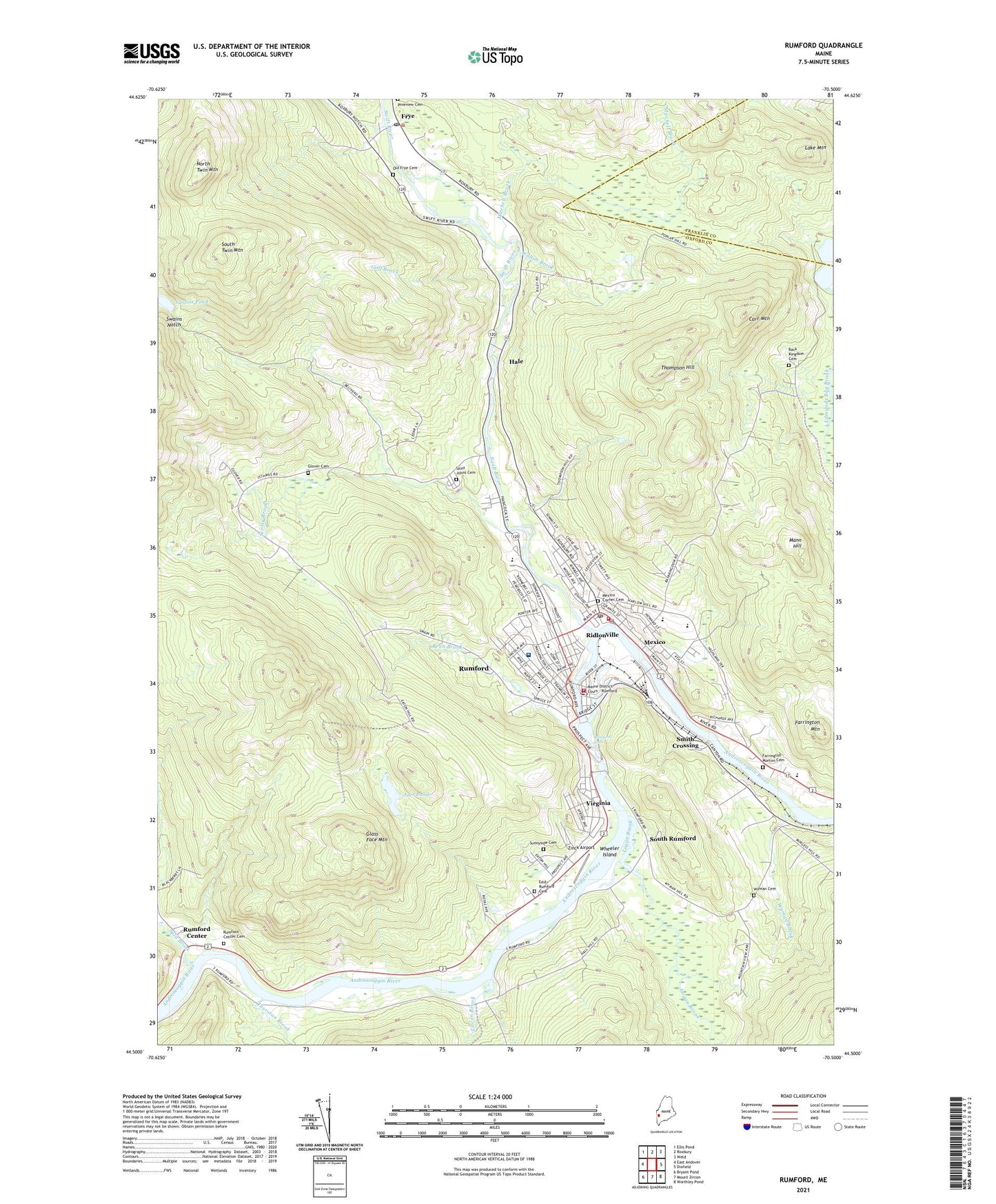
2024 topographic map quadrangle Rumford in the state of Maine. Scale: 1:24000. Based on the newly updated USGS 7.5' US Topo map series, this map is in the following counties: Oxford, Franklin. The map contains contour data, water features, and other items you are used to seeing on USGS maps, but also has updated roads and other features. This is the next generation of topographic maps. Printed on high-quality waterproof paper with UV fade-resistant inks.
Quads adjacent to this one:
West: East Andover
Northwest: Ellis Pond
North: Roxbury
Northeast: Weld
East: Dixfield
Southeast: Worthley Pond
South: Mount Zircon
Southwest: Bryant Pond
This map covers the same area as the classic USGS quad with code o44070e5.
Contains the following named places: Abbott School, Androscoggin River Reservoir, Back Kingdom Cemetery, Bean Brook, Bisbee School, Carr Mountain, Chisholm School, East Rumford Cemetery, Farrington - Morton Cemetery, Farrington Mountain, First Baptist Church, Frye, Glass Face Mountain, Glover Cemetery, Goff Brook, Hale, Halfmoon Pond, Holy Savior School, Hunt Airfield, Joes Pond, Kimball School, Kingdom Hall of Jehovahs Witnesses, Lake Mountain, Logan Brook, Mann Hill, Mechanic Institute, Med Care Ambulance Service, Meroby Elementary School, Mexico, Mexico Census Designated Place, Mexico Congregational Church, Mexico Corner Cemetery, Mexico Fire Department, Mexico Free Public Library, Mexico Police Department, Mexico Post Office, Middle Dam, Mitchell Brook, Mountain Valley High School, Mountain Valley Middle School, North Twin Mountain, Oakdale Country Club, Old Frye Cemetery, Old Rumford Dam, Pettengill School, Praise Assembly of God Church, Ridlonville, Ridlonville Post Office, River Valley Christian School, Roy House Rumford Group Home School, Roy House School, Rumford, Rumford Census Designated Place, Rumford Center, Rumford Center Cemetery, Rumford Elementary School, Rumford Falls, Rumford Fire Department, Rumford Group Home, Rumford Hospital, Rumford Hospital Health Science Library, Rumford Police Department, Rumford Post Office, Rumford Public Library, Saint Athanasius and Saint Johns Roman Catholic Church, Saint Barnabas Episcopal Church, Saint Johns Cemetery, Saint Johns School, Saint Theresas Church, School of Applied Technology Region 9, Scotty Brook, Smith Crossing, South Rumford, South Twin Mountain, Split Brook, Sunnyside Cemetery, Swains Notch, Swains Pond, Swift River, Swift River Reservoir, The Church of Jesus Christ of Latter Day Saints, Thompson Hill, Thurston Brook, Thurston Mill Dam, Town of Mexico, Town of Rumford, United Methodist Church, Upper Dam, Virgin Memorial Chapel, Virginia, Virginia School, Walton Brook, Wheeler Island, WTME-AM ( Rumford), Wyman Brook, Wyman Cemetery, Zinck Airport, Zircon Brook