MyTopo
Skowhegan Maine US Topo Map
Couldn't load pickup availability
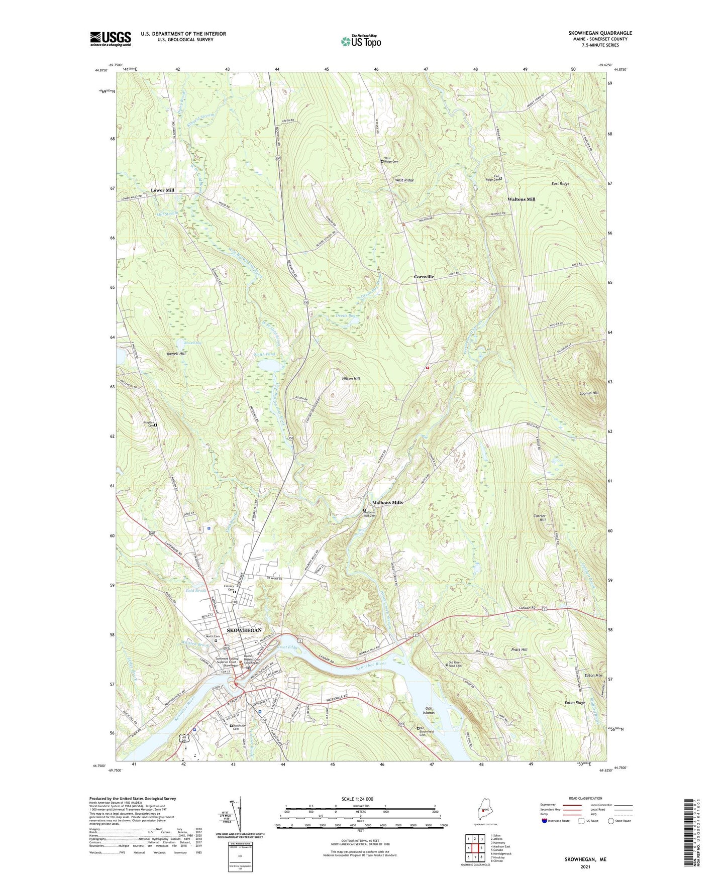
2021 topographic map quadrangle Skowhegan in the state of Maine. Scale: 1:24000. Based on the newly updated USGS 7.5' US Topo map series, this map is in the following counties: Somerset. The map contains contour data, water features, and other items you are used to seeing on USGS maps, but also has updated roads and other features. This is the next generation of topographic maps. Printed on high-quality waterproof paper with UV fade-resistant inks.
Quads adjacent to this one:
West: Madison East
Northwest: Solon
North: Athens
Northeast: Harmony
East: Canaan
Southeast: Clinton
South: Hinckley
Southwest: Norridgewock
Contains the following named places: All Saints Episcopal Church, Bloomfield Elementary School, Calvary Cemetery, Coburn Park, Cold Brook, Cold Brook Dam, Cornville, Cornville Church, Cornville Volunteer Fire Department, Cummings Art School, Currier Brook, Currier Hill, Devils Bog, Devils Bog Brook, East Ridge, East Ridge Cemetery, Eaton Mountain, Eaton Ridge, Great Eddy, Haley Brook, Hayden Cemetery, Hewett Marsh, Hewett Marsh Dam, Hilton Hill, History House, Kennebec River Reservoir, Kennebec Village Shopping Center, Kincaid Stream, Ledge Brook, Loomis Hill, Lower Mill, Maine State Police Troop C, Maine State Reformatory for Women, Malbons Mill Cemetery, Malbons Mills, Margaret Chase Smith Library, Margaret Chase Smith School Skowhegan, Memorial Field, Mill Stream, North Cemetery, North Elementary School, Notre Dam De Lourdes Catholic Church, Oak Islands, Old Bloomfield Cemetery, Old River Road Cemetery, Orthodox Presbyterian Church, Pratt Hill, Redington - Fairview General Hospital, Redington Fairview General Hospital Health Science Library, Revere School, Riverfront Church of God, Rowell Bog, Rowell Hill, Sampsons Shopping Center, Skowhegan, Skowhegan Area High School, Skowhegan Area Middle School, Skowhegan Census Designated Place, Skowhegan Community Center, Skowhegan Federated Church, Skowhegan Fire Station, Skowhegan Municipal Building, Skowhegan Police Department, Skowhegan Post Office, Skowhegan Public Library, Skowhegan State Fair Grounds, Skowhegan Village Shopping Center, Skowhegan Waste Treatment Plant, Smith Pond, Somerset Career and Technical Center School, Somerset County Court House Library, Somerset County Courthouse, Somerset County Jail, Somerset County Sheriff's Office, Southside Cemetery, Town of Cornville, Town of Skowhegan, Trinity Evangelical Free Church, Two Rivers Campground, Village Plaza Mall Shopping Center, Waltons Mill, Wesserunsett Stream, West Branch Cold Brook, West Ridge, Weston Dam, Whitten Brook, Yonder Hill Campground, ZIP Code: 04976