MyTopo
Betterton Maryland US Topo Map
Couldn't load pickup availability
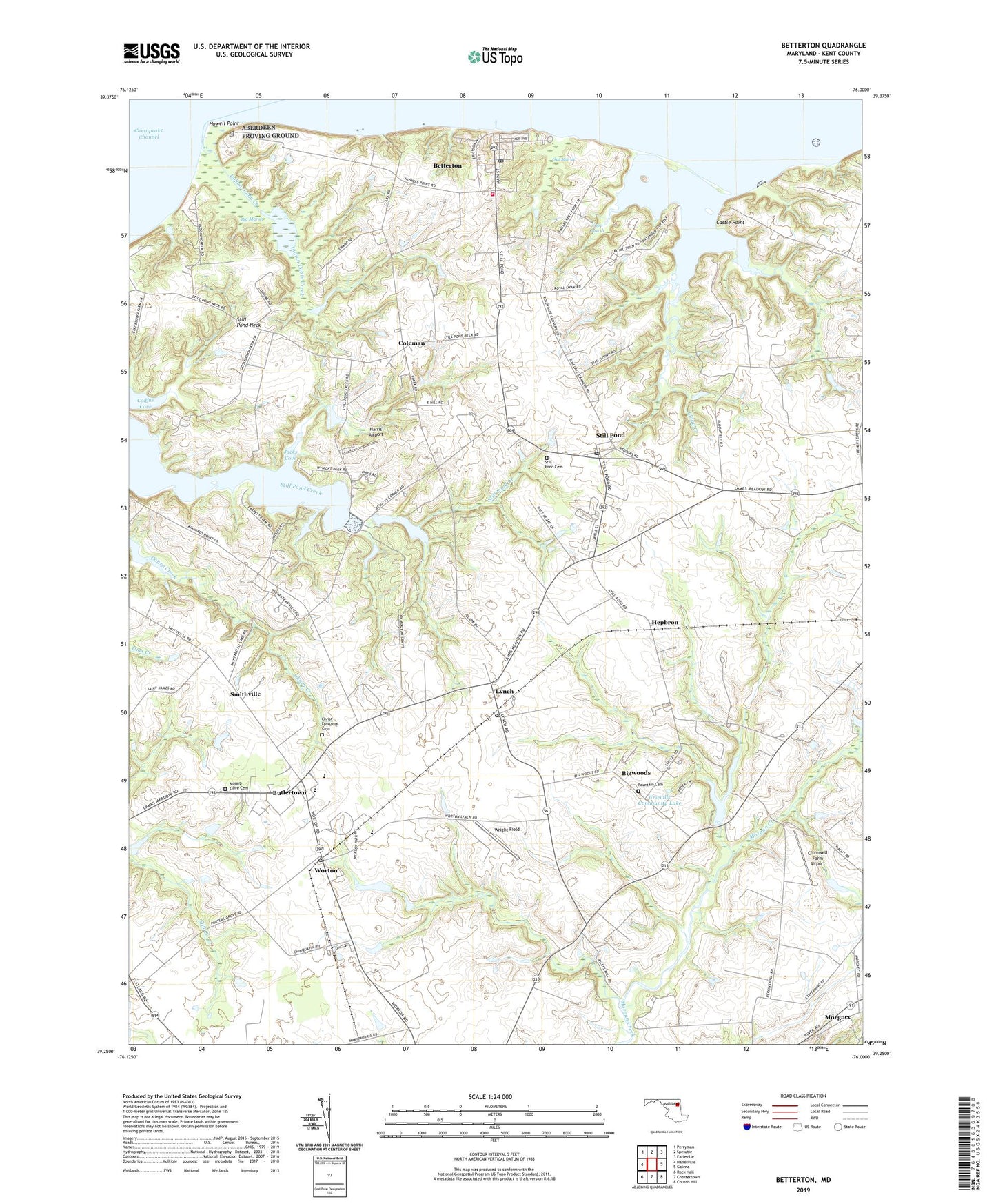
2023 topographic map quadrangle Betterton in the state of Maryland. Scale: 1:24000. Based on the newly updated USGS 7.5' US Topo map series, this map is in the following counties: Kent. The map contains contour data, water features, and other items you are used to seeing on USGS maps, but also has updated roads and other features. This is the next generation of topographic maps. Printed on high-quality waterproof paper with UV fade-resistant inks.
Quads adjacent to this one:
West: Hanesville
Northwest: Perryman
North: Spesutie
Northeast: Earleville
East: Galena
Southeast: Church Hill
South: Chestertown
Southwest: Rock Hall
This map covers the same area as the classic USGS quad with code o39076c1.
Contains the following named places: Betterton, Betterton Beach Park, Betterton Community Park, Betterton Historic District, Betterton Lutheran Church, Betterton Post Office, Betterton Town Hall, Betterton United Methodist Church, Betterton Volunteer Fire Company Station 5, Big Marsh, Bigwoods, Blooming Turkey Farm, Butlertown, Butlertown Census Designated Place, Camp Echo Hill, Camp Tockwogh Maintenance Office, Camp TockwoghYMCA, Castle Point, Catts Corner, Christ Church, Christ Episcopal Cemetery, Coleman, Cromwell Farm Airport, District 3 Worton (Betterton), Echo Hill, Elgin Farm Pond Dam, Fair Promise Stock Farm, Fish Hall Farm, Five Rivers Farm, Fountain Cemetery, Fountain Church, Friends Meeting House, Friendship Montessori School Elementary School, Goose Hill, Gut Marsh, Harris Airport, Harris Wharf, Hassengers Corner, Hepbron, Howell Point, Indian Cabin Creek, Jacks Cove, Kent Airport, Kent and Queen Annes Hospital Heliport, Kent County High School, Kentfield, Lakeview Mennonite Church, Lloyd Creek, Lynch, Lynch Post Office, Lynch United Methodist Church, Morgan Creek Branch Dam, Morgnec, Mount Olive Cemetery, Mount Olive Church, Mount Zion Church, Nuodex Incorporated Heliport, Parson Hill, Robinson Corner, Runnymeade Estates, Saint Johns Church, School Number 2, School Number 3, School Number 4, School Number 5, School Number 6, Smith Field, Smithville, Still Pond, Still Pond Cemetery, Still Pond Census Designated Place, Still Pond Neck, Still Pond Post Office, Still Pond Station, The Pines, Town of Betterton, Union Church, Urieville, Urieville Community Lake, Urieville Lake Fish Management Area, Urieville Park, Watts Farm Pond Dam, White House Farm, WKHS-FM (Worton), Worton, Worton Census Designated Place, Worton Elementary School, Worton Manor Mobile Home Park, Worton Post Office, Worton Regional Park, Wright Field, Yapp Marsh, ZIP Codes: 21610, 21667, 21678