MyTopo
Chestertown Maryland US Topo Map
Couldn't load pickup availability
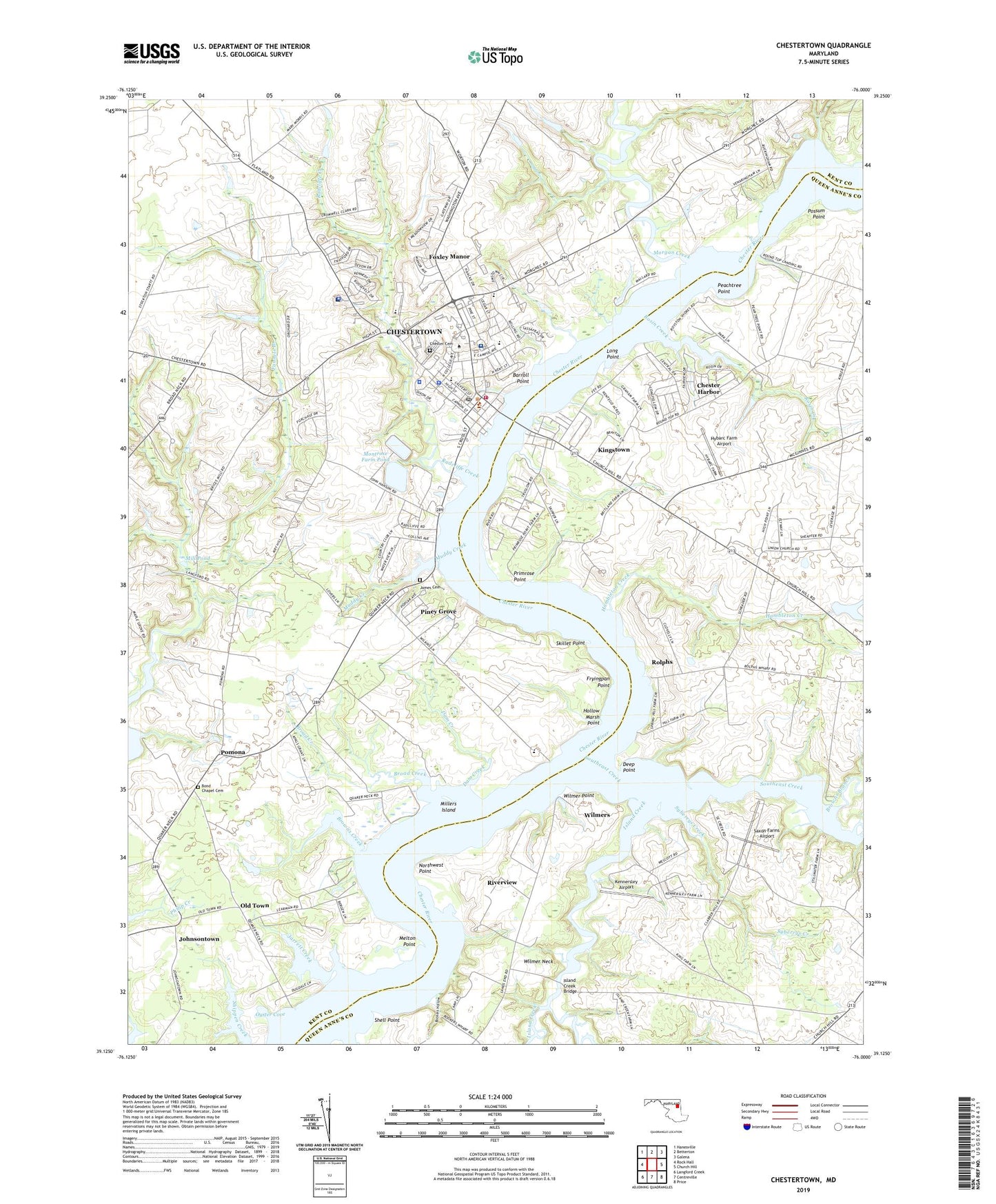
2023 topographic map quadrangle Chestertown in the state of Maryland. Scale: 1:24000. Based on the newly updated USGS 7.5' US Topo map series, this map is in the following counties: Kent, Queen Anne's. The map contains contour data, water features, and other items you are used to seeing on USGS maps, but also has updated roads and other features. This is the next generation of topographic maps. Printed on high-quality waterproof paper with UV fade-resistant inks.
Quads adjacent to this one:
West: Rock Hall
Northwest: Hanesville
North: Betterton
Northeast: Galena
East: Church Hill
Southeast: Price
South: Centreville
Southwest: Langford Creek
This map covers the same area as the classic USGS quad with code o39076b1.
Contains the following named places: Allegany House, Alumni House - Washington College, Amberly Trailer Park, Anne Arundell House, Athey Field, Barroll Point, Benjamin A Johnson Lifetime Fitness Center, Bethel African Methodist Episcopal Church, Boathouse Cove, Bond Chapel, Bond Chapel Cemetery, Bookers Hollow, Bookers Wharf, Broad Creek, Brown Cottage, Browns Branch, Browns Creek, Buck Bacchus Store Museum, Buckingham Wharf, Bunting Hall, Cain Athletic Center, Calvert Heights, Camp Pecometh, Caroline House, Carroll House, Casey Academic Center, Casey Swim Center, Catlin, Cecil House, Charles House, Chesmar, Chester Cemetery, Chester Harbor, Chester River Country Club, Chestertown, Chestertown Baptist Church, Chestertown Business Park, Chestertown Christian Academy, Chestertown Elementary School, Chestertown High School, Chestertown Historic District, Chestertown Nursing and Rehabilitation Center, Chestertown Police Department, Chestertown Post Office, Chestertown Seventh Day Adventist Church, Chestertown Stabilization Pond Number 1 Dam, Chestertown Stablization Pond Number Two Dam, Chestertown Town Hall, Chestertown Volunteer Fire Company Station 6, Christ United Methodist Church, Church of the Living God, Church of the Nazarene, Church on the Rock, Clifton M Miller Library, Coventry Farms, Crestview, Crestview Square Shopping Center, Daly Hall, Dam Creek, Decker Laboratory Center, Deep Point, Devils Reach, District 4 Chestertown, District 7 Pomona, Dorchester House, Dunning Hall, Emmanuel Episcopal Church, Emmanuel United Methodist Church, Fanels Branch, Fannells Meadow, Fannels Branch, First Baptist Church, First United Methodist Church, Fishing Creek, Foxley Manor, Frederick House, Friends Meeting House, Fryingpan Point, Garnett High School, Gibson Center and Tawes Theatre, Goldstein Hall, Granny Finley Branch, Hambleton Creek, Harford House, Harrisburg, Heather Heights, Henry Highland Garnett Elementary School, Heron Point, Hodson Hall, Hollow Marsh Point, Hybarc Farm Airport, Hynson-Ringgold House, Island Creek, Island Creek Bridge, James Cemetery, Janes United Methodist Church, Jarrett Creek, Johnsontown, Jordan Landing, Kennersley, Kennersley Airport, Kennersley Pointe Marina, Kent and Queen Annes Rescue Squad Station 8, Kent County, Kent County Courthouse, Kent County Farm, Kent County Health Center, Kent County Jail and Detention Center, Kent County Middle School, Kent County Public Library, Kent County Sheriff's Office, Kent Plaza Shopping Center, Kent School Elementary School, Kibler Field, Kings Court, Kings Town Manor, Kings Town Park, Kingstown, Kingstown Census Designated Place, Kirwan Meditation Garden, Langford Acres, Larrabee Arts Center, Lees Corner, Lelia Hynson Pavilion, Liberty Lighthouse Church, Long Point, Magnolia Hall Nursing Home, Maryland State Police, Maryland State Police - Chestertown Detachment, Melton Point, Methodist Meeting House, Middle House, Mile Tree Village, Mill Pond, Millers Island, Minta Martin Hall, Montrose Farm Pond, Morgan Creek, Morganec Village, Muddy Creek, Newmans Wharf, Northwest Point, Nussbaum House, Old Town, Orchard Hill, Owings Farm Pond Dam, Oyster Cove, Peachtree Point, Pear Tree Point, Piney Grove, Pomona, Possum Point, Primrose Garth, Primrose Point, Prince George's House, Quaker Neck Landing, Queen Anne's House, Radcliff Creek Industrial Park, Radcliffe Creek, Radcliffe Creek School Elementary School, Reba L Anthony Estates, Reid Hall School, River Edge, Riverside Wharf, Riverview, Rolphs, Rolphs Wharf, Rolphs Wharf Marina, Rose O'Neill Literary House, Rosin Creek, Roundtop Park, Roundtop Wharf, Royston Shores, Sacred Heart Roman Catholic Church, Saint Mary's House, Saxon Farms Airport, Scheeler Field, School Number 6, School Number 7, School Number 8, Schottland Tennis Pavilion, Scott Point Marina, Sears House, Shell Point, Shriver Field, Silver Hill Airport, Skillet Point, Somerset House, Southeast Creek, Southeast Landing, Syberrys Creek, Talbot House, The Customs House, The Grove, The John S Toll Science Center Complex, Town of Chestertown, Trinity Lutheran Church, Truslow Boat House, Union Church, Union School, University of Maryland Shore Medical Center at Chestertown, Upper Shore Community Mental Health Center, Washington College, Washington Park, WCTR-AM (Chestertown), White Swan Tavern, Wide Hall, William Smith Hall, Wilmer Neck, Wilmer Park, Wilmer Point, Wilmers, Worcester Hall, ZIP Code: 21620