MyTopo
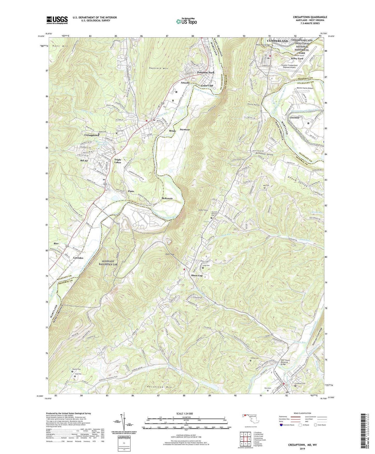
Cresaptown Maryland US Topo Map
Couldn't load pickup availability
2023 topographic map quadrangle Cresaptown in the states of West Virginia, Maryland. Scale: 1:24000. Based on the newly updated USGS 7.5' US Topo map series, this map is in the following counties: Allegany, Mineral. The map contains contour data, water features, and other items you are used to seeing on USGS maps, but also has updated roads and other features. This is the next generation of topographic maps. Printed on high-quality waterproof paper with UV fade-resistant inks.
Quads adjacent to this one:
West: Lonaconing
Northwest: Frostburg
North: Cumberland
Northeast: Evitts Creek
East: Patterson Creek
Southeast: Springfield
South: Headsville
Southwest: Keyser
Contains the following named places: Abe Cemetery, Ackerman, Allegany County Detention Center, Amcelle, Amcelle Acres, Appalachian Orchard, Bel Air, Bel Air Census Designated Place, Bier Census Designated Place, Bowling Green, Bowling Green Volunteer Fire Department, Brady, Buckwheat Hollow, Cecil Cemetery, Cedar Cliff, Cresaptown, Cresaptown Census Designated Place, Cresaptown Elementary School, Cresaptown Post Office, Cresaptown Volunteer Fire Department, Cresaptown-Bel Air Census Designated Place, Culp Cemetery, Cumberland Fair Grounds, Dayton Cemetery, District 3, District 7 Cresaptown/Bel Air, Federal Correctional Institution Cumberland, Fire and Rescue Institute University Of Maryland, Fort Ashby, Fort Ashby Post Office, Fort Ashby Primary School, Fort Ashby Volunteer Fire Company, Frankfort Cemetery, Frankfort High School, Frankfort Intermediate School, Frankfort Middle School, Frost, Greater Cumberland Regional Airport, Horseshoe Creek, Ilechiter Monnett Cemetery, Inkeep Cemetery, Keller Run, Knobly Tunnel, Koulip Hollow, Lease Cemetery, Long Cemetery, Long Pasture Run, Lowndes, McKenzie, McKenzie Tower, Mexico Farms, Mexico Farms Airport, Mill Run, Myers Run, North Branch Correctional Institution, Old Furnace Church, Painter Run, Pinto, Pinto Orchard Spring, Pinto Post Office, Pinto Utilities Dam, Pinto Utilities Reservoir, Potomac, Potomac Park, Potomac Park Census Designated Place, Renix, Rice Cemetery, Richard Powhall Spring, Riverside, Rocket Center, Seymour, Short Gap, Short Gap Primary School, Short Gap Volunteer Fire Company, Small World Academy, SSGT Shuck Memorial Bridge, Triple Lakes, Turners Run, Warrior Run, Welton Tunnel, Western Correctional Institution, Wiley Ford, Wiley Ford Bridge, Wiley Ford Census Designated Place, Wiley Ford Church of the Brethren, Wiley Ford Post Office, Wiley Ford Primary School, Wiley Ford Volunteer Fire Company, Wileys Ford, WKZG-FM (Keyser), ZIP Codes: 26753, 26767