MyTopo
Hampstead Maryland US Topo Map
Couldn't load pickup availability
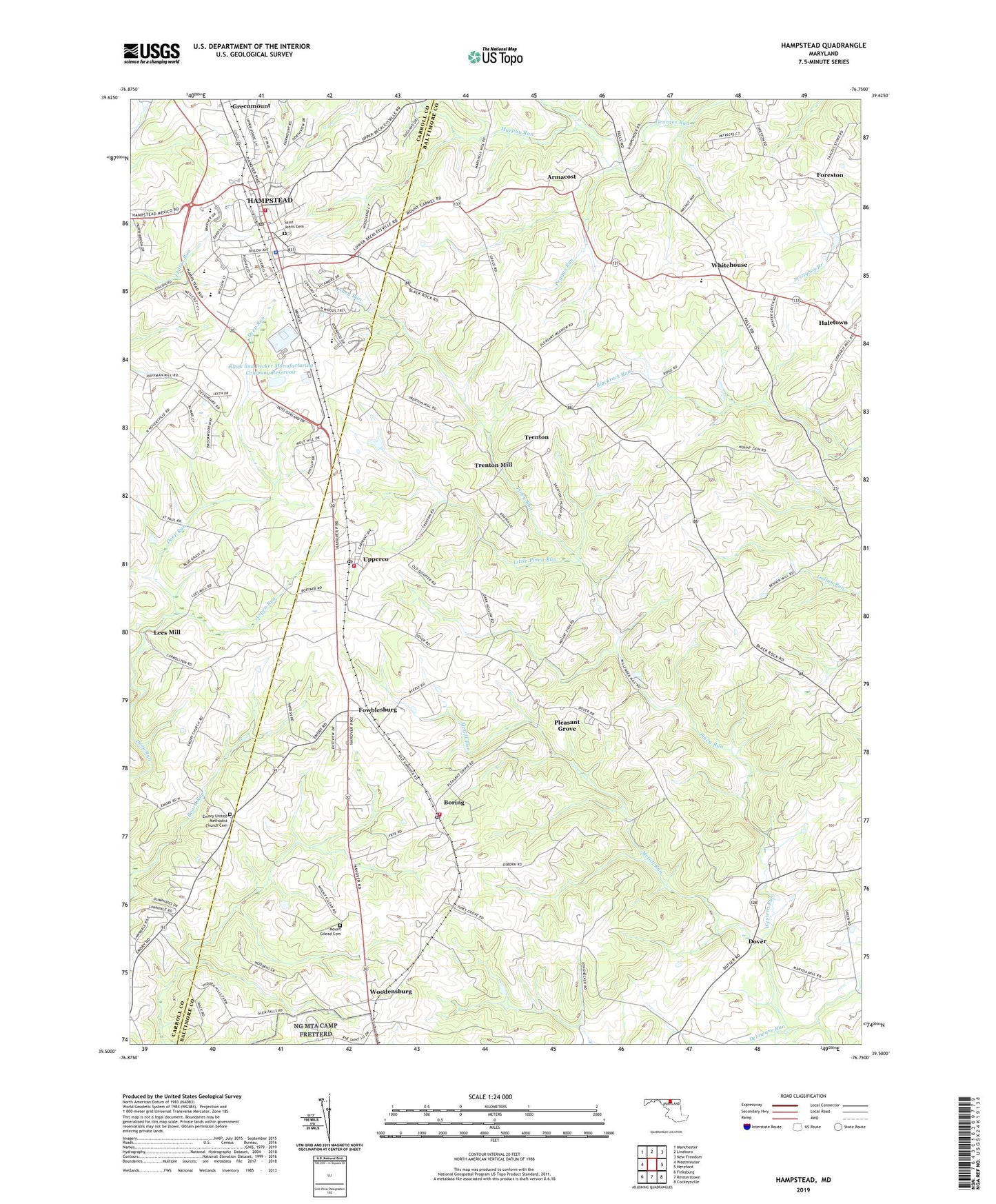
2023 topographic map quadrangle Hampstead in the state of Maryland. Scale: 1:24000. Based on the newly updated USGS 7.5' US Topo map series, this map is in the following counties: Baltimore, Carroll. The map contains contour data, water features, and other items you are used to seeing on USGS maps, but also has updated roads and other features. This is the next generation of topographic maps. Printed on high-quality waterproof paper with UV fade-resistant inks.
Quads adjacent to this one:
West: Westminster
Northwest: Manchester
North: Lineboro
Northeast: New Freedom
East: Hereford
Southeast: Cockeysville
South: Reisterstown
Southwest: Finksburg
This map covers the same area as the classic USGS quad with code o39076e7.
Contains the following named places: Alma Meadows, Arcadia Volunteer Fire Company Station 43, Arched Bow Valley, Armacost, Aspen Run, Berrywood Village, Black and Decker Manufacturing Company Dam, Black and Decker Manufacturing Company Reservoir, Black and Decker Stormwater Pond Dam, Blue Grass Manor, Boring, Boring Post Office, Boring United Methodist Church, Boring Volunteer Fire Company Station 42, Brilhart Terrace, Brookmead Farms, Buena Vista Estates, Carroll County Fire Department Station 2 Hampstead Volunteer Company, Carrs Store, Castle Oaks, Cedarbrook, Clear View, Clydesdale Acres, Crestview Meadows, Delaware Run, District 5, District 8 Hampstead, Dover, Dover Church, Emory Church, Emory United Methodist Church Cemetery, England Estates, Fenwood Heights, Fifth District Elementary School, Forest Church, Foreston, Fowblesburg, Grace United Methodist Church, Gunpowder Game Farm, Haletown, Hampstead, Hampstead Elementary School, Hampstead Heights, Hampstead Memorial Park, Hampstead Police Department, Hampstead Post Office, Hampstead Town Hall, Hampstead Valley, Hampstead Wastewater Treatment Plant, Highfield Estates, Hunter Green, Kempfield, Kingston Riding, Lees Mill, Little Piney Run, Loblolly Farm, Martins Tree Farm, McGill Run, Melanie Acres, Montrose Chapel, Morning Star Christian School, Mount Gilead Cemetery, Mount Zion Church, Murphy Run, North Carroll High School, Oakdale Manor, Peggys Run, Piney Branch Golf Course, Piney Grove Church, Piney Run, Pleasant Grove, Pleasant Grove Methodist Church, Pleasant Run, Roberts Field, Roberts Field Business Center, Saint Johns Cemetery, Saint Johns Church, Saint Johns United Methodist Church, Saint Mark Lutheran Church, Saint Pauls Lutheran Church, Scotts Ridge, Shiloh Middle School, Singer Heights, Small Crossings, Southglenn Farms, Southwood, Spring Garden Elementary School, Steeplechase, Town of Hampstead, Trenton, Trenton Mill, Trenton Mills Farm, Upperco, Upperco Post Office, Waterspout Run, WGRX-FM (Westminster), Whitehouse, Wolf Hill, Woodensburg, ZIP Codes: 21074, 21155