MyTopo
Mardela Springs Maryland US Topo Map
Couldn't load pickup availability
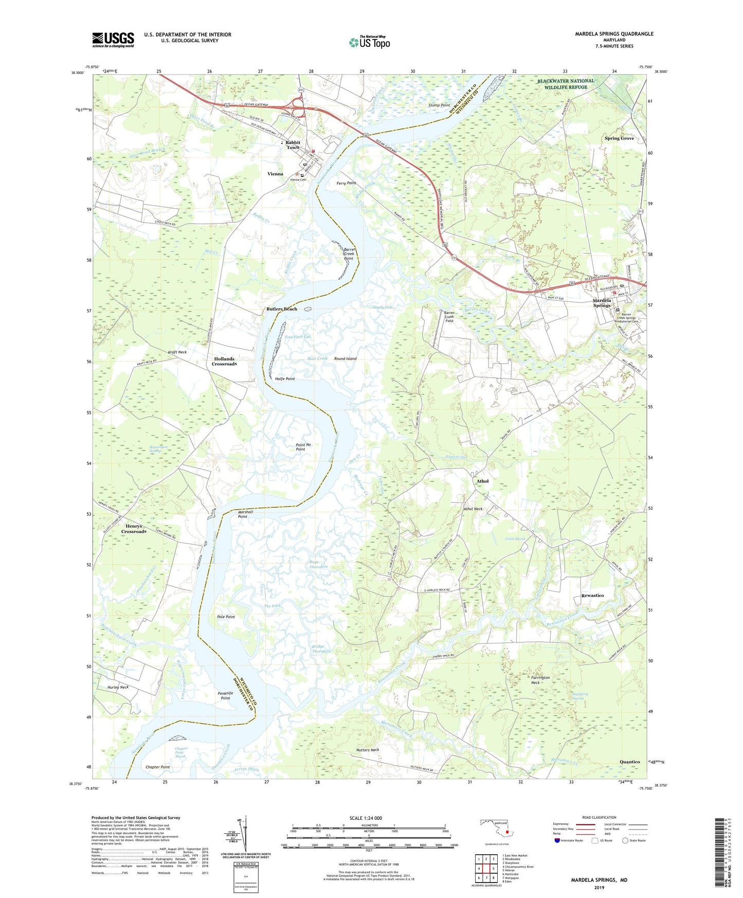
2023 topographic map quadrangle Mardela Springs in the state of Maryland. Scale: 1:24000. Based on the newly updated USGS 7.5' US Topo map series, this map is in the following counties: Wicomico, Dorchester. The map contains contour data, water features, and other items you are used to seeing on USGS maps, but also has updated roads and other features. This is the next generation of topographic maps. Printed on high-quality waterproof paper with UV fade-resistant inks.
Quads adjacent to this one:
West: Chicamacomico River
Northwest: East New Market
North: Rhodesdale
Northeast: Sharptown
East: Hebron
Southeast: Eden
South: Wetipquin
Southwest: Nanticoke
This map covers the same area as the classic USGS quad with code o38075d7.
Contains the following named places: Allanbank Nursery, Athaloo Landing, Athol, Athol Neck, Barren Creek, Barren Creek Field, Barren Creek Point, Barren Creek Presbyterian Church, Barren Creek Springs Presbyterian Cemetery, Beaverdam Swamp, Big Ridges, Birdcage Creek, Bradleys Creek, Bridge Creek, Bridge Thorofare, Butlers Beach, Camp Merrill, Camphels Wharf, Chapter Point, Chapter Point Marsh, Cherry Walk Estates, Cherrywalk, Chicone Creek, Creek Marsh, Den Creek, Devils Woodyard, District 1 Barren Creek, Emmanuel Church, Farrington Neck, Ferry Point, First Baptist Church, First Pilgrim Holiness Church, Governor Hicks House, Halfe Point, Henrys Crossroads, Henrys Crossroads School, Hollands Crossroads, Hurley Neck, Ingem Gut, Jenkins Landing, Kraft Neck, Lewis Landing, Little Creek, Little Ridges, Little Thorofare, Manumsco Creek, Maple Shade School, Mardela Springs, Mardela Springs Park, Mardela Springs Post Office, Mardela Springs Volunteer Fire Department Station 9, Mardella Springs Town Hall, Mares Branch, Marshall Point, Mill Branch, Mill Creek, Mount Nebo United Methodist Church, Mount Pleasant Church, Muir Creek, Oak Terrace Trailer Park, Peachorchard Creek, Penknife Point, Point No Point, Pole Point, Quantico Census Designated Place, Quantico Creek, Rabbit Town, Rags Thorofare, Redfin Creek, Rewastico, Rewastico Creek, Rewastico Pond Dam, Round Island, Round Island Gut, Sageberry Swamp, Saint Pauls Episcopal Church, Sandy Gut, Spring Grove, Stump Gut, Stump Point, The Customs House, The Ferry House, The Inlet, Tom Fitch Gut, Tom Fitchs Gut, Toms Gut, Town Branch, Town of Mardela Springs, Town of Vienna, Vienna, Vienna Cemetery, Vienna Elementary School, Vienna Post Office, Vienna United Methodist Church, Vienna Volunteer Fire Company Station 11, Wapremander Creek, Wesleyan Church, ZIP Code: 21837