MyTopo
Salisbury Maryland US Topo Map
Couldn't load pickup availability
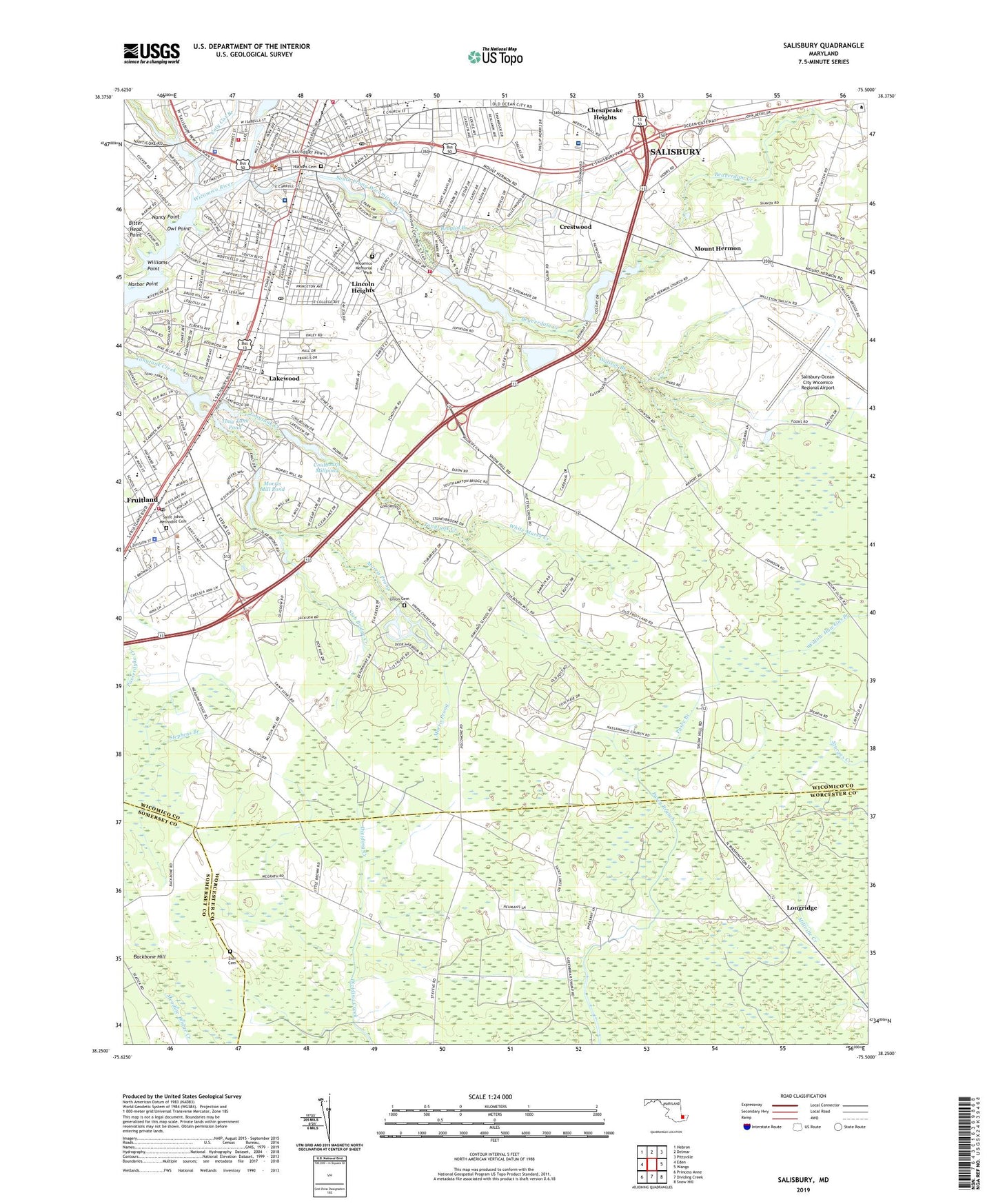
2023 topographic map quadrangle Salisbury in the state of Maryland. Scale: 1:24000. Based on the newly updated USGS 7.5' US Topo map series, this map is in the following counties: Wicomico, Worcester, Somerset. The map contains contour data, water features, and other items you are used to seeing on USGS maps, but also has updated roads and other features. This is the next generation of topographic maps. Printed on high-quality waterproof paper with UV fade-resistant inks.
Quads adjacent to this one:
West: Eden
Northwest: Hebron
North: Delmar
Northeast: Pittsville
East: Wango
Southeast: Snow Hill
South: Dividing Creek
Southwest: Princess Anne
This map covers the same area as the classic USGS quad with code o38075c5.
Contains the following named places: Abundant Life Christian Academy, Air Business Center, Allenwood Building, Asbury Child Development Center, Autumn Grove, Backbone Hill, Baileys Mill, Baileys Woods, Beacon House, Beaglin Branch, Beaglin Park Dam, Beaverdam Creek, Bellavance Honors Center, Belmont, Bitter Head Point, Blackwell Library, Brafferton, Brookshire Knolls, California, Camage House, Camden, Camden House, Camden Parking Lot E, Camden Parking Lot F, Canal Walk Park, Canton, Carey Heights, Caruthers Hall, Center for Conflict Resolution, Chelsea Court, Chesapeake Country Fair Shopping Center, Chesapeake Hall, Chester Hall, Choptank Hall, City of Fruitland, Colbourn Manor, College Square Post Office, Commons Building, Commons Dining Hall, Coty Cox Branch, Coulborn Mill Valley, Coulbourn Millpond, Covered Bridge Estates, Crestwood, Deep Harbour, Devilbiss Hall, Devilbiss Science Hall, District 13 Camden, District 8 Nutters, Doe Run, Dogwood Parking Lot D, Dogwood Village, Druid Hill Park, East Salisbury Elementary School, Eastview Park, Elks Golf Course, Faculty Development House, Fairfield, Fairfield Park, Foggy Bottom, Fooks School, Forks Pond Dam, Foundation Center, Foxchase, Frankford, Fruitland, Fruitland Business Park, Fruitland City Hall, Fruitland Intermediate School, Fruitland Police Department, Fruitland Post Office, Fruitland Primary School, Fruitland Recreational Park, Fruitland Volunteer Fire Department Station 3, Fulton Hall, Glen Avenue Elementary School, Green Forest Estates, Guerreiri University Center, Guerrieri University Center, Handys Landing, Harbor Point, Harmon Field, HealthSouth Chesapeake Rehabilitation Hospital, Henson Science Hall, Heritage Manor, Highland Park, Holloway Hall, Holly Center, Hollywood, Hotton Acres, Hunting Park, Hustons Cemetery, James Bennett Junior High School, James M Bennett High School, Jersey, John B Parsons Home for the Aged, John Walstons Mobile Home Park, Jones Pond, Kaywood, Kilbirnie Estates, Lakeside at Mallard Landing, Lakewood, Lincoln Heights, Linda Manor, Livingston Heights, Longridge, Maggs Activity Center, Maggs Physical Activities Center, Magnolia Terrace, Main Street Post Office, Manokin Hall, Meadow Bridge Greenhouse, Midvale Manor, Minksville, Monument Park, Moonglow Manor, Moores Corner, Morris Mill, Morris Mill Pond, Morris Mill Pond Dam, Morris Prong, Mount Hermon, Mount Hermon Heights, Mount Olive Manor, Nancy Point, Nanticoke Hall, Nevins Addition, Nevins Mill, Newton Historic District, Nichols Plaza Shopping Center, North Kaywood, North Prong Wicomico River, Nutters Crossing Golf Course, Oakland Acres, Owens Branch, Owl Point, PACE House, Park Lake, Park Manor, Park Seventh Day Adventist Elementary School, Parker Pond, Parker Pond Dam, Parkside High School, Parkway Christian Academy Elementary School, Pecan Acres, Pemberton Elementary School, Peninsula General Hospital Ground Level Heliport, Peninsula Regional Medical Center, Perrys Haven, Pheasant Run, Philmore Park, Pinehurst Elementary School, Pocomoke Hall, Potomac Hall, Powell Center, Power Professional Building, President's Residence - Salisbury University, Prince Street Elementary School, Pryor Branch, Quail Ridge, Riverside Homes, Riverside Pines, Rustic Acres, Saint Francis De Sales School, Saint Johns Methodist Cemetery, Saint Lukes, Saint Martin Hall, Salisbury, Salisbury Academy, Salisbury Baptist Academy, Salisbury City Hall, Salisbury Fire Department Station 1, Salisbury Fire Department Station 16, Salisbury Fire Department Station 16 Headquarters, Salisbury Fire Department Station 2, Salisbury Fire Training Center, Salisbury Mall Shopping Center, Salisbury Naval Outer Landing Field, Salisbury Nursing Home, Salisbury Police Department, Salisbury Post Office, Salisbury School, Salisbury Shopping Center, Salisbury University, Salisbury Wastewater Treatment Plant, Salisbury-Ocean City Wicomico Regional Airport, Scarborough Leadership Center, Schumaker Park, Schumaker Pond, Severn Hall, Shad Point Bridge Dam, Shopping World Shopping Center, Slab Bridge Creek, Sojourner Douglass College - Salisbury, South Prong Wicomico River, Stepping Stones Learning Academy, Student Art Center, Suburban Acres, Summit, Sunayr, Theatre and Web Development House, Thomas E Ballavance Honors Center, Tony Tank Pond, Tonytank, Tonytank Pond, Trace Hollow, Twilley Center Shopping Center, U. S. Parking Lot A, U. S. Parking Lot B, U. S. Parking Lot C, Union Cemetery, Walston Branch, Washington Heights, Waycroft, White Marsh Creek, White Plains, WICO-AM (Salisbury), WICO-FM (Salisbury), Wicomico County Courthouse, Wicomico County Evening High School, Wicomico County Free Library, Wicomico Day School, Wicomico Hall, Wicomico High School, Wicomico Memorial Park, Wicomico Middle School, Wicomico Orphanage, Wild Fowl Museum, Williams Point, Windham Manor, Woodfield, Wor Wic Community College, Zion Cemetery, ZIP Codes: 21802, 21804