MyTopo
Marion Massachusetts US Topo Map
Couldn't load pickup availability
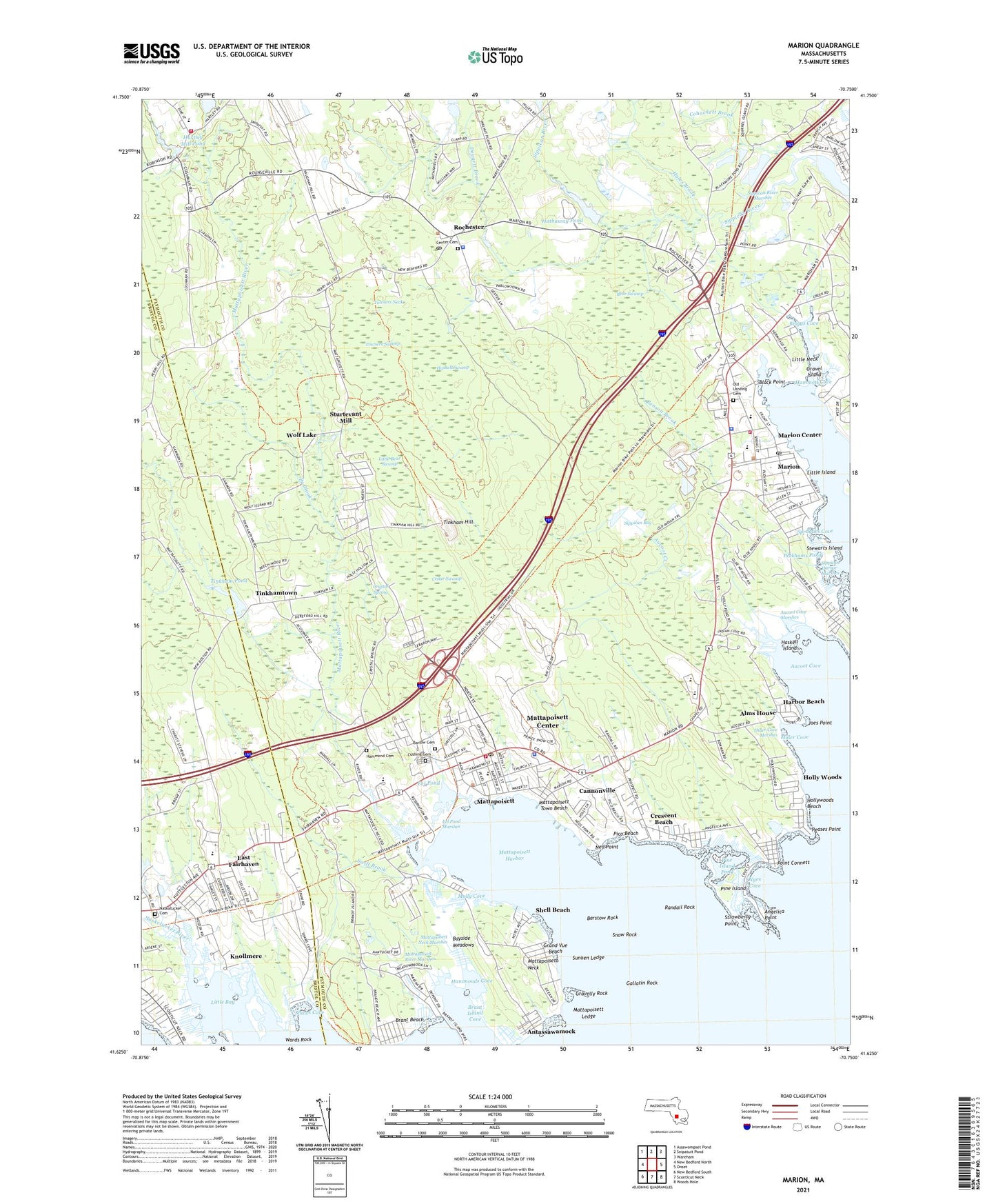
2021 topographic map quadrangle Marion in the state of Massachusetts. Scale: 1:24000. Based on the newly updated USGS 7.5' US Topo map series, this map is in the following counties: Plymouth, Bristol. The map contains contour data, water features, and other items you are used to seeing on USGS maps, but also has updated roads and other features. This is the next generation of topographic maps. Printed on high-quality waterproof paper with UV fade-resistant inks.
Quads adjacent to this one:
West: New Bedford North
Northwest: Assawompset Pond
North: Snipatuit Pond
Northeast: Wareham
East: Onset
Southeast: Woods Hole
South: Sconticut Neck
Southwest: New Bedford South
Contains the following named places: Alms House, Angelica Point, Antassawamock, Aucoot Cove, Aucoot Cove Marshes, Aucoot Creek, Barlow Cemetery, Barstow Rock, Bayside Meadows, Bear Swamp, Benson Brook, Black Point, Branch Brook, Brant Beach, Brant Island, Brant Island Cove, Briggs Cove, Camp Echo, Cannonville, Cedar Swamp, Center Cemetery, Charles E Washburn Memorial Park, Cohackett Brook, Crescent Beach, Crystal Spring, Cushing Cemetery, Doggett Brook, East Fairhaven, East Fairhaven School, Eel Pond, Eel Pond Marshes, First Congregational Church, Gallatin Rock, Grand Vue, Grand Vue Beach, Gravel Island, Gravelly Rock, Hales Brook, Hammett Cove, Hammond Cemetery, Hammonds Cove, Harbor Beach, Hartley Mill Pond, Hartley Saw Mill Dam, Haskell Island, Haskell Swamp, Hathaway Pond, Hathaway Pond Dam, Hiller Cove, Hiller Cove Marshes, Holly Woods, Hollywoods Beach, Joes Point, Joseph H Plumb Memorial Library, Knollmere, Leonards Pond Dam, Little Bay, Little Bear Swamp, Little Island, Little Neck, Marion, Marion Center Census Designated Place, Marion Fire Department Headquarters, Marion Police Department, Marion Post Office, Marion Station, Marion Town Hall, Marion United Methodist Church, Mattapoisett, Mattapoisett Center Census Designated Place, Mattapoisett Congregational Church, Mattapoisett Fire Department Headquarters, Mattapoisett Harbor, Mattapoisett Hidtorical Society Building, Mattapoisett Ledge, Mattapoisett Neck, Mattapoisett Neck Marshes, Mattapoisett Police Department, Mattapoisett Post Office, Mattapoisett Public Library, Mattapoisett River, Mattapoisett River Marshes, Mattapoisett Shipyard Park, Mattapoisett Town Beach, Mattapoisett Town Hall, Mattapoisett Town Wharf, Molly Cove, Nasketucket, Nasketucket River, Ned Point, Ned Point Light, Neds Point Light, New Boston Chapel, Nyes Cove, Old Hammondtown School, Old Landing Cemetery, Old Rochester Regional High School, Old Rochester Regional Junior High School, Peases Point, Peckhams Pond, Pico Beach, Pine Island, Pine Island Brook, Pine Island Pond, Point Connett, Ram Island, Randall Rock, Reservation Country Club, Rochester, Rochester Fire Department, Rochester Fire Department Ambulance Service, Rochester Golf Course, Rochester Memorial School, Rochester Police Department, Rochester Post Office, Rochester Town Hall, Rounseville Pond, Saint Anthonys Church, Saint Gabriels Church, Saint Ritas Church, Saint Rose of Lima Church, Saint Rose of Lima School, Shaws Cove, Shell Beach, Sherman Brook, Sippican Bog, Sippican Harbor Marshes, Sippican Historical Society Building, Sippican River Marshes, Sippican School, Snow Rock, South Shore Marshes Wildlife Management Area, Spragues Cove, Stewart Island, Stewarts Island, Strawberry Point, Sturtevant Mill, Sunken Ledge, Swift Brook, Tabor Academy, Third Meetinghouse, Tinkham Hill, Tinkham Pond, Tinkham Pond Dam, Tinkhamtown, Town of Fairhaven, Town of Mattapoisett, Towsers Neck, Towsers Swamp, Wards Rock, WJFD-FM (New Bedford), Wolf Lake, ZIP Codes: 02719, 02738, 02739