MyTopo
Onset Massachusetts US Topo Map
Couldn't load pickup availability
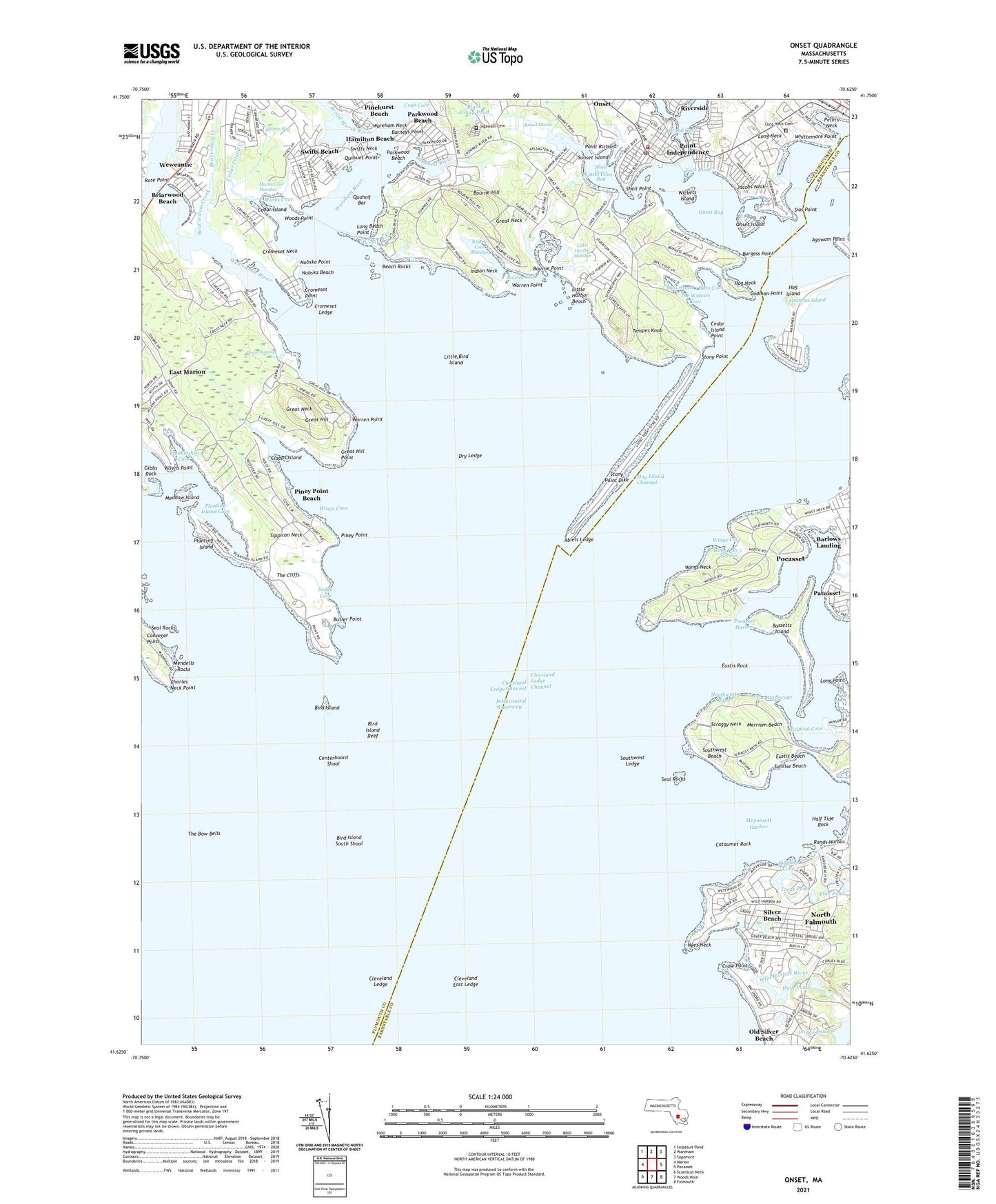
2024 topographic map quadrangle Onset in the state of Massachusetts. Scale: 1:24000. Based on the newly updated USGS 7.5' US Topo map series, this map is in the following counties: Plymouth, Barnstable. The map contains contour data, water features, and other items you are used to seeing on USGS maps, but also has updated roads and other features. This is the next generation of topographic maps. Printed on high-quality waterproof paper with UV fade-resistant inks.
Quads adjacent to this one:
West: Marion
Northwest: Snipatuit Pond
North: Wareham
Northeast: Sagamore
East: Pocasset
Southeast: Falmouth
South: Woods Hole
Southwest: Sconticut Neck
This map covers the same area as the classic USGS quad with code o41070f6.
Contains the following named places: Abiels Ledge, Agawam Cemetery, Agawam Point, Allens Point, Barlows Landing, Barneys Point, Bass Cove, Bass Creek, Bassetts Island, Beach Rocks, Beaverdam Creek, Bird Island, Bird Island Light, Bird Island Reef, Bird Island South Shoal, Black Jonny Pond, Blankinship Cove, Bourne Cove, Bourne Cove Marshes, Bourne Hill, Bourne Point, Briarwood Beach, Broad Cove, Broad Marsh, Broad Marsh River, Burgess Point, Butler Cove, Butler Point, Cataumet Rock, Cedar Island, Cedar Island Creek, Cedar Island Point, Centerboard Shoal, Charles Neck Point, Clapps Island, Cleveland East Ledge, Cleveland Ledge, Cleveland Ledge Channel, Cleveland Ledge Channel Range Light, Cleveland Ledge Light, Cleveland Ledge Lighthouse, Codman Point, Converse Point, Crab Cove, Cromeset Ledge, Cromeset Neck, Cromeset Point, Crooked River, Crow Point, Dam Pond, Dry Ledge, East Marion, East River, Ethel E Hammond School, Eustis Beach, Eustis Rock, Fiddlers Cove, Flax Pond, Gateway Shopping Plaza, Gibbs Rock, Great Hill, Great Hill Point, Great Neck, Great Swamp, Half Tide Rock, Hamilton Beach, Hog Island, Hog Island Channel, Hog Neck, Hospital Cove, Indian Neck, Jacobs Neck, Kittanset Golf Club, Little Bird Island, Little College Pond, Little Harbor, Little Harbor Beach, Little Harbor Golf Course, Little Harbor Marshes, Little Long Pond, Long Beach Point, Long Neck, Long Neck Cemetery, Long Point, Main Street Shopping Center, Marks Cove, Marks Cove Marshes, Mashnee Island, Meadow Island, Megansett Harbor, Mendells Rocks, Merriam Beach, Nobska Beach, Nobska Point, North Falmouth Census Designated Place, Northwest Cove, Nyes Neck, Old Silver Beach, Onset, Onset Bay, Onset Census Designated Place, Onset Fire Department Station 1 Headquarters, Onset Island, Onset Post Office, Onset Town Wharf, Parkwood Beach, Patuisset, Peters Neck, Phinneys Harbor Channel Light, Pinehurst Beach, Piney Point, Piney Point Beach, Planting Island, Planting Island Cove, Pleasant Harbor, Pocasset Census Designated Place, Pocasset Harbor, Point Independence, Point Independence Yacht Club, Point Richard, Quahog Bar, Quasuet Point, Rands Harbor, Red Brook Harbor, Rose Point, Sacred Heart Seminary, Scraggy Neck, Seal Rocks, Sedge Cove, Shell Point, Shell Point Bay, Sias Point, Silver Beach, Silver Beach Harbor, Sippican Harbor, Sippican Neck, Sippican River, Southwest Beach, Southwest Ledge, Stones Bog, Stony Point, Stony Point Dike, Sunrise Beach, Sunset Cove, Sunset Island, Swifts Beach, Swifts Neck, Tempes Knob, The Anchorage, The Bow Bells, The Cliffs, The Widows Cove, Town of Marion, Trout Pond, Wareham Center Census Designated Place, Wareham Country Club, Wareham Neck, Wareham Plaza, Wareham River, Warren Point, Weweantic, Weweantic Census Designated Place, Weweantic River, Whittemore Point, Wickets Island, Wild Harbor, Wild Harbor River, Wings Cove, Wings Cove Marshes, Wings Neck, Wings Neck Lighthouse, Wings Pond, Woods Point, ZIP Code: 02558