MyTopo
New Bedford South Massachusetts US Topo Map
Couldn't load pickup availability
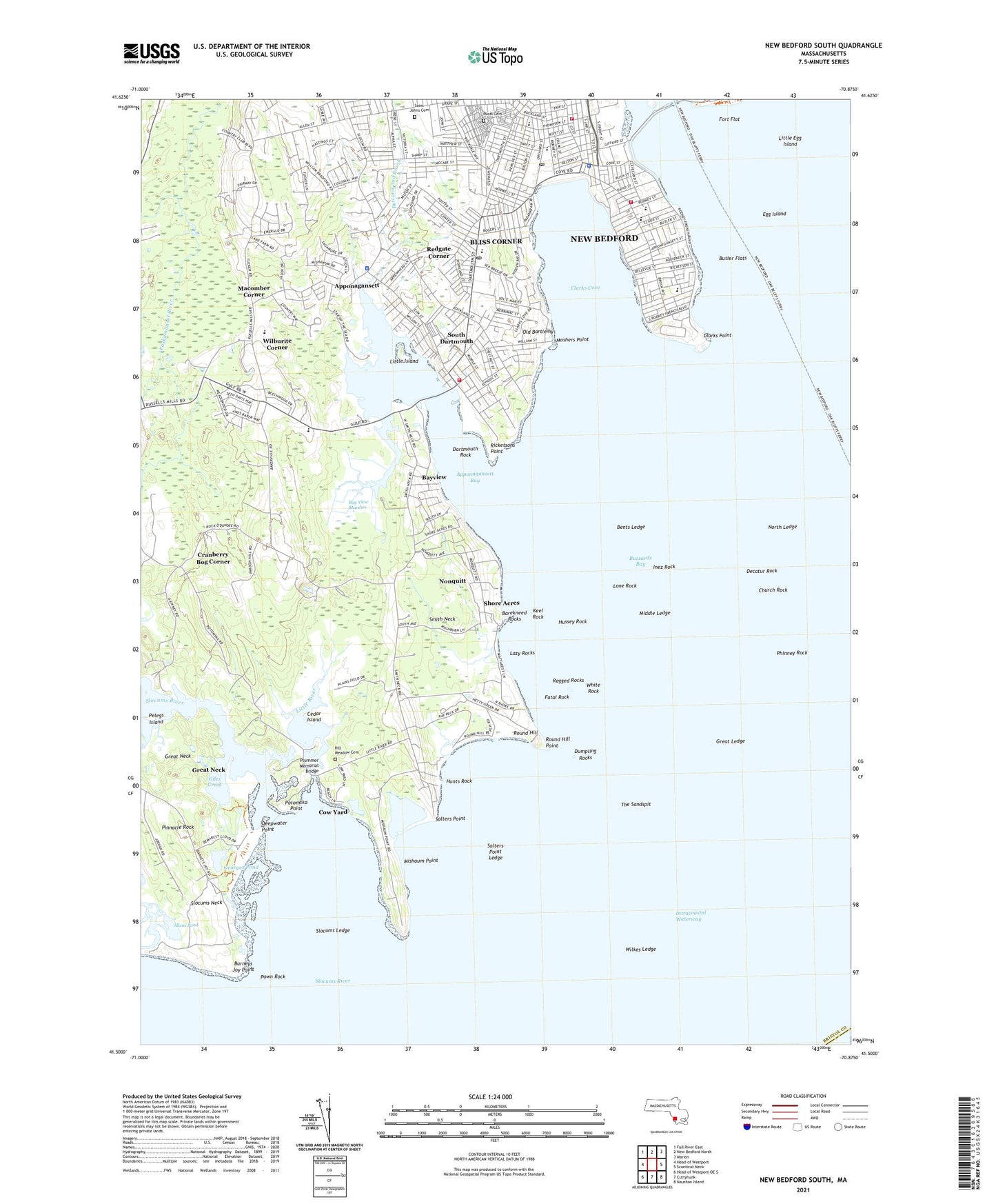
2024 topographic map quadrangle New Bedford South in the state of Massachusetts. Scale: 1:24000. Based on the newly updated USGS 7.5' US Topo map series, this map is in the following counties: Bristol, Dukes. The map contains contour data, water features, and other items you are used to seeing on USGS maps, but also has updated roads and other features. This is the next generation of topographic maps. Printed on high-quality waterproof paper with UV fade-resistant inks.
Quads adjacent to this one:
West: Head of Westport
Northwest: Fall River East
North: New Bedford North
Northeast: Marion
East: Sconticut Neck
Southeast: Naushon Island
South: Cuttyhunk
Southwest: Head of Westport OE S
This map covers the same area as the classic USGS quad with code o41070e8.
Contains the following named places: Allendale Country Club, Andrew B Cushman School, Apponagansett, Apponagansett Bay, Apponagansett Church, Apponagansett Point Recreation Area, Ashley Park, Barekneed Rocks, Barneys Joy Point, Bay View Marshes, Bayview, Bents Ledge, Bliss Corner, Bliss Corner Census Designated Place, Brooklyn Rock, Butler Flats, Butler Flats Light, Butler Flats Lighthouse, Buttonwood Brook, Cedar Island, Church Rock, Clarks Cove, Clarks Point, Cow Yard, Cranberry Bog Corner, Dartmouth Fire Department District 1 Station 1 Headquarters, Dartmouth Police Department Headquarters, Dartmouth Rock, De Valle School, Decatur Rock, Deepwater Point, Demarest Lloyd Memorial State Park, Donaghy School, Dumpling Rocks, Dumplings Rocks Light, Egg Island, Fatal Rock, Fort Flat, Fort Phoenix Beach State Reservation, Friends Academy, George H Dunbar School, Georges Pond, Giles Creek, Great Ledge, Great Neck, Hawthorne Country Club, Hazelwood Park, Hill Meadow Cemetery, Hunts Rock, Hunts Rock Breakwater, Hussey Rock, Inez Rock, Ingraham Pre-School Center, James B Congdon School, John B Devalles School, John Hannigan School, Jones Park, Joseph DeMello School, Keel Rock, Lazy Rocks, Little Egg Island, Little Island, Little River, Lone Rock, Macomber Corner, Middle Ledge, Mishaum Point, Moshers Point, New Bedford East Barrier Light, New Bedford Fire Department Station 11, New Bedford Fire Department Station 6, New Bedford Harbor, New Bedford Police Department Station 2, New Bedford West Barrier Light, Nonquitt, North Ledge, Old Bartlemy, Orchard Street Post Office, Padanaram Breakwater, Padanaram Breakwater Light, Pawn Rock, Pelegs Island, Phinney Rock, Pinnacle Rock, Plummer Memorial Bridge, Potomska Point, Ragged Rocks, Redgate Corner, Ricketsons Point, Roosevelt Junior High School, Round Hill, Round Hill Point, Rural Cemetery, Saint Annes School, Saint Hedwig School, Saint James Church, Saint John the Baptist Cemetery, Salters Point, Salters Point Ledge, Schwartz Day School, Shore Acres, Slocums Ledge, Slocums Neck, Slocums River, Smith Neck, Smith Neck Church, Solemar Hospital, South Dartmouth, South Dartmouth Post Office, The Sandspit, Town of Dartmouth, WCTK-FM (New Bedford), White Rock, Wilburite Corner, Wilkes Ledge, William H Taylor School, WNBH-AM (New Bedford), ZIP Codes: 02744, 02748