MyTopo
Wareham Massachusetts US Topo Map
Couldn't load pickup availability
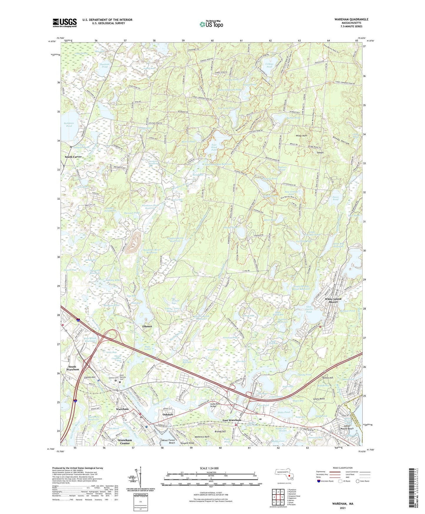
2024 topographic map quadrangle Wareham in the state of Massachusetts. Scale: 1:24000. Based on the newly updated USGS 7.5' US Topo map series, this map is in the following counties: Plymouth, Barnstable. The map contains contour data, water features, and other items you are used to seeing on USGS maps, but also has updated roads and other features. This is the next generation of topographic maps. Printed on high-quality waterproof paper with UV fade-resistant inks.
Quads adjacent to this one:
West: Snipatuit Pond
Northwest: Plympton
North: Plymouth
Northeast: Manomet
East: Sagamore
Southeast: Pocasset
South: Onset
Southwest: Marion
This map covers the same area as the classic USGS quad with code o41070g6.
Contains the following named places: Abner Pond, Agawam River, Bangs Bog, Bangs Heliport, Barret Pond, Bartlett Pond, Bartletts Marsh, Beaver Dam Pond, Besse Bog Reservoir, Besse Bog Reservoir Dam, Blackmere Reservoir, Brandy Hill, Bumps Pond, Bumpus Bog, Cachalot Scout Reservation, Camp Rockne, Camp Squanto, Carver Bog, Cattle Pond, Cedar Pond, Cedar Ponds, Central Cemetery, Centre Cemetery, Charge Pond, Church of the Good Shepherd, Church of the Nazarene, Clear Pond, College Pond, Cranberry Plaza, Cranberry Plaza Shopping Center, Cranberry Village, Crane Brook Bog Dam, Crane Brook Bog Pond, Deer Pond, Dicks Pond, Doctors Pond, Dunham Pond, East Branch Maple Springs Brook, East Head Bog Dam Number One, East Head Bog Dam Number Two, East Head Bog Reservoir, East Head Pond, East Head Pond Dam, East Wareham, East Wareham Elementary School, East Wareham Post Office, East Wareham Station, Ellis School, Faith Baptist Church, Fawn Pond, Fearing Pond, Fearing Tavern, Federal Bogs, Federal Pond, Federal Pond Dam, Feed My Lambs Fellowship Church, First Congregational Church, Fiske Bogs, Fivemile Pond, Fivemile Ponds, Frogfoot Brook, Frogfoot Brook Reservoir, Frogfoot Reservoir Dam, Gibbs Brook, Glen Charlie Pond, Glen Charlie Pond Dam, Golden Field Pond, Golden Field Pond Dam, Grady Pond, Grassy Pond, Gurney Bogs, Hammond Bogs, Harlow Brook, Harlow Brook Number One Dam, Harlow Brook Number Two Dam, Harlow Brook Reservoir, Harwich Bogs, Harwich Lower Reservoir Dam, Harwich Reservoir, Harwich Upper Reservoir Dam, Hebron Tabernacle Church, Horseshoe Pond, Horseshoe Pond Dam, Indian Heights, Indian Mound Beach, Jefferson Shores, Jenney Bogs, John William Decas School, John William Decas School Library Media Center, Jonathans Pond, Kendrick House Museum, Lewis Point, Lincoln Hill, Little Fivemile Pond, Locke Bogs, Lower Sampson Pond, Maple Park Bogs, Maple Springs Bog, Maple Springs Brook, Maple Springs Brook Number One Dam, Maple Springs Brook Reservoir, Maple Swamp, Massachusetts Correctional Institution Forestry Camp, Mayflower Road Dam, Mill Pond, Miller Cove, Minot Forest Beach, Minot Forest School, Mosquito Pond, Mount Carmel Baptist Church, Muddy Cove, Muddy Cove Marshes, Myles Standish State Forest, New Grassy Pond, New Long Pond, Oakdale, Old Orchard Bogs, Onset Fire Station 2, Onset Station, Ortolani Number Three Dam, Ortolani Number Two Dam, Ortolani Reservoir, Parker Mills Bogs, Parker Mills Pond, Parker Mills Pond Dam, Parker Mills Station, Pine Tree Village, Popes Pond, Pratt Pond, Queen Sewell Cove, Raccoon Pond, Red Brook, Rhody Hollow, Riverside, Robbins Bog, Rogers Bog, Rogers Bogs, Rose Brook, Rose Brook Lower Dam, Rose Brook Reservoir, Round Pond, Russell Bogs, Saint Patrick's Cemetery, Saint Patricks Church, Salt Marsh, Sampson Brook, Sand Pond, Sandy Pond, Sawpit, Shaw Bogs, Smalley Bogs, Smelt Pond, South Carver, South Carver Post Office, South Shore Community Church, South Wareham, South Wareham Post Office, South Wareham Station, Spectacle Pond, Starr Bogs, State Bogs, Steep Bank Bridge, Stillman Library, Stony Run, Tabernacle of Praise Church, Tarkiln Hill, Tempest Knob, Tempest Knob Station, Three Cornered Pond, Tihonet, Tihonet Cranberry Bogs, Tihonet Pond, Tihonet Pond Number One Dam, Tihonet Pond Number Two Dam, Tilson Brook, Tobey - Jones Reservoir, Tobey - Jones Reservoir Dam, Tobey Hospital, Torrey Pond, Town of Wareham, Tremont Street Dam, Union Pond, Walsh Bog, Wankinco Cranberry Bog, Wankinco Neck, Wankinco River, Wankinco River Dam Number One, Wankinco River Dam Number Two, Wankinco River Reservoir, Wareham, Wareham Center, Wareham Emergency Medical Services, Wareham Fire Department Station 1 Headquarters, Wareham Fire Department Station 2, Wareham Fire Department Station 3, Wareham Fire Department Station 4, Wareham High School, Wareham Middle School, Wareham Narrows, Wareham Police Department, Wareham Post Office, Wareham Senior High School, Wareham Station, Wareham Town Hall, Wesley United Methodist Church, White Island Shores, White Island Shores Census Designated Place, Wings Hole, ZIP Codes: 02366, 02538, 02571