MyTopo
New Bedford North Massachusetts US Topo Map
Couldn't load pickup availability
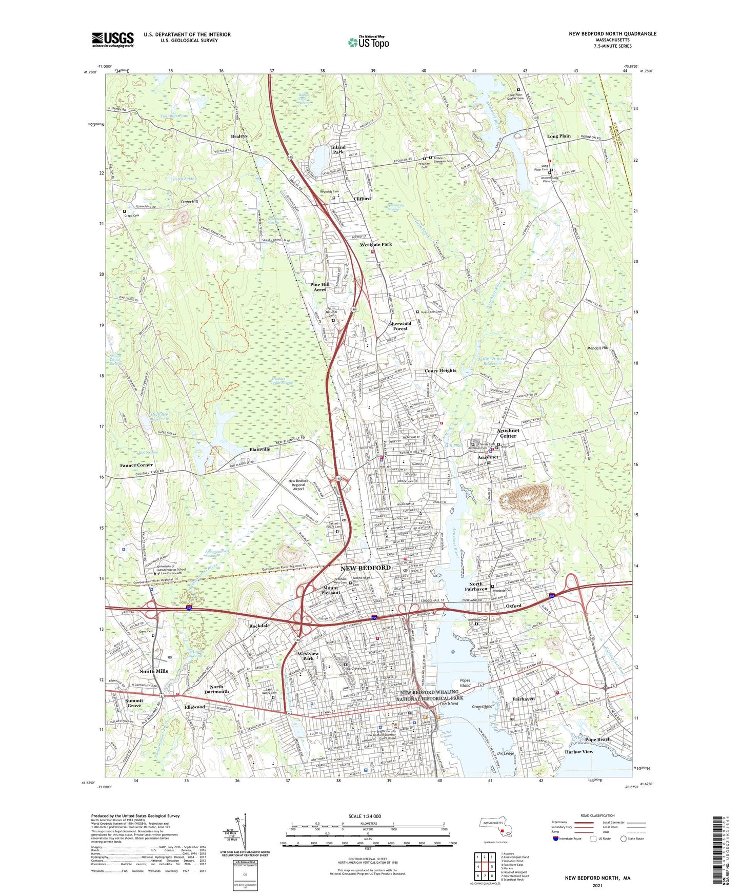
2024 topographic map quadrangle New Bedford North in the state of Massachusetts. Scale: 1:24000. Based on the newly updated USGS 7.5' US Topo map series, this map is in the following counties: Bristol, Plymouth. The map contains contour data, water features, and other items you are used to seeing on USGS maps, but also has updated roads and other features. This is the next generation of topographic maps. Printed on high-quality waterproof paper with UV fade-resistant inks.
Quads adjacent to this one:
West: Fall River East
Northwest: Assonet
North: Assawompset Pond
Northeast: Snipatuit Pond
East: Marion
Southeast: Sconticut Neck
South: New Bedford South
Southwest: Head of Westport
This map covers the same area as the classic USGS quad with code o41070f8.
Contains the following named places: Abraham Lincoln School, Acushnet, Acushnet Cedar Swamp, Acushnet Cemetery, Acushnet Center Census Designated Place, Acushnet Elementary School, Acushnet Fire Department Station 1 Headquarters, Acushnet Fire Department Station 2 Long Plain, Acushnet Fire Department Station 3, Acushnet Police Department, Acushnet Post Office, Acushnet River, Acushnet River Reservoir, Acushnet River Seaplane Base, Acushnet Station, Albert F Ford Middle School, Alfred J Gomes School, Anthony School, Apponagansett Swamp, Bedford Industrial Park, Berdon Plaza, Betsey B Winslow School, Betty Spring, Bishop Stang High School, Braleys, Bristol County Sheriff's Office, Brooklawn Park, Burt School, Buttonwood Park, Calvary Church, Central New Bedford Historic District, Charles S Ashley School, City of New Bedford, Clark Street School, Clifford, Clifford Chapel, Clifford School, Cook School, Coury Heights, Crapo Cemetery, Crapo Hill, Crow Island, Cushman Park, Dartmouth Fire Department District 3 Station 3, Dartmouth High School, Dartmouth Middle School, Deep Brook, Dix Ledge, Doane Memorial Field, Early Learning Child Care Center, Elizabeth Canter Brooks School, Elizabeth Hastings Junior High School, Ellen R Hathaway School, Elwyn G Campbell School, Fairhaven, Fairhaven Fire Department, Fairhaven High School, Fairhaven High School Library, Fairhaven Plaza, Fairhaven Police Department, Fairhaven Post Office, Fairhaven Townhall, Faunce Corner, Fish Island, Flag Swamp, Flying Cloud Orchards, George F Reynolds Cemetery, Greater New Bedford Vocational Technical School, Hamlin Road Dam, Hamlins Pond, Harbor View, Hathaway Swamp, Hawes Pond, Hawes Pond Dam, Hayden-McFadden School, High Hill Reservoir, High Hill Reservoir Dam, Hobomock Swamp, Holy Family-Holy Name School, Horatio A Kempton School, House of Corrections, Howard School, Idlewood, Inland Park, James M Quinn School, Jireh Swift School, Job S Gidley School, John Avery Parker School, Joseph Davis Burial Ground, Keene River, Keith Junior High School, Knowlton School, Leroy Wood Grammar School, Little People's College, Livesey Park, Long Plain, Long Plain Cemetery, Massachusetts State Pier, Massachusetts State Police Station D3 Dartmouth Barracks, Mediplex Rehabilitation Hospital, Mendall Hill, Mill Pond, Millicent Library, Mount Pleasant, Mount Pleasant Post Office, Mount Pleasant School, Mount Pleasant Station, New Bedford, New Bedford Army Air Field, New Bedford City Hall, New Bedford Community Center, New Bedford Country Club, New Bedford Emergency Medical Service, New Bedford Fire Department Station 1 Headquarters, New Bedford Fire Department Station 5, New Bedford Fire Department Station 7, New Bedford Fire Department Station 8, New Bedford Fire Department Station 9, New Bedford Free Public Library, New Bedford Global Learning HMCS School, New Bedford High School, New Bedford Police Department Headquarters, New Bedford Police Department Station 1, New Bedford Police Department Station 3, New Bedford Post Office, New Bedford Regional Airport, New Bedford Reservoir, New Bedford Reservoir Dam, New Bedford Vocational High School, New Bedford Whaling National Historical Park, Normandin Junior High School, North Dartmouth, North Dartmouth Mall, North Dartmouth Post Office, North Fairhaven, North Hill Plaza, North New Bedford High School, North Post Office, Oak Grove Cemetery, Oxford, Oxford School, Palmer Island, Peckham West Cemetery, Perry Hill Church, Phillips Avenue School, Pine Hill Acres, Plainville, Polish National Catholic Cemetery, Poole Junior High School, Pope Beach, Popes Island, Pulaski School, Riverside Cemetery, Rockdale, Rogers School, Roseanne Barker Library and Media Center, Sacred Heart Academy, Sacred Heart Cemetery, Sacred Heart Church, Sacred Heart Old Cemetery, Saint Francis Xavier School, Saint Josephs School, Saint Joseph-Saint Therese School, Saint Kilians School, Saint Lukes Hospital, Saint Marys Cemetery, Saint Marys School, Saint Theresas Church, Sarah D Ottiwell School, Sassaquin Pond, Seamens Bethel Museum, Seargent William H Carney Academy, Sherwood Forest, Smith Mills, Smith Mills Census Designated Place, South New Bedford High School, Southeastern Massachusetts Educational Collaborative School, Squam Brook, Stat Ambulance, Stat Ambulance Service of New England, Stop and Shop Center, Summit Grove, Tabor Cemetery, Tarkiln Hill, Thomas R Rodman School, Town of Acushnet, Tripp School, Turner Pond, Turner Pond Dam, Turner Pond on High Hill Road Dam, Twinings Pond, Union Hospital, WBSM-AM (New Bedford), West Side Junior-Senior High School, Westgate Park, Westview Park, WFHN-FM (Fairhaven), Whaling Museum, WLAW-AM (Fairhaven), Woodside Cemetery, ZIP Codes: 02740, 02743, 02745, 02746