MyTopo
Mount Toby Massachusetts US Topo Map
Couldn't load pickup availability
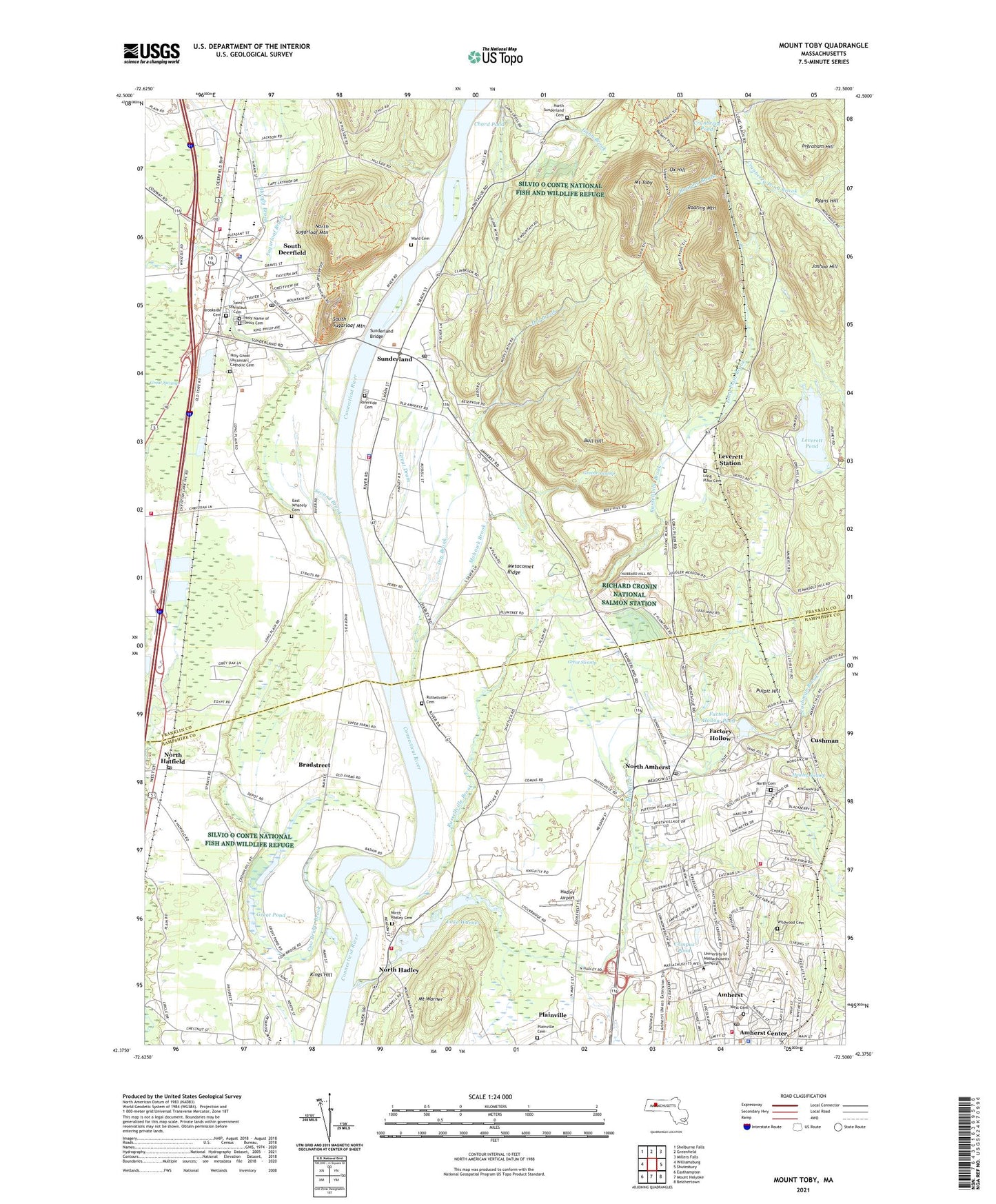
2024 topographic map quadrangle Mount Toby in the state of Massachusetts. Scale: 1:24000. Based on the newly updated USGS 7.5' US Topo map series, this map is in the following counties: Franklin, Hampshire. The map contains contour data, water features, and other items you are used to seeing on USGS maps, but also has updated roads and other features. This is the next generation of topographic maps. Printed on high-quality waterproof paper with UV fade-resistant inks.
Quads adjacent to this one:
West: Williamsburg
Northwest: Shelburne Falls
North: Greenfield
Northeast: Millers Falls
East: Shutesbury
Southeast: Belchertown
South: Mount Holyoke
Southwest: Easthampton
Contains the following named places: Amherst, Amherst Center, Amherst Center Census Designated Place, Amherst Fire Department - Central Station, Amherst Fire Department - North Station, Amherst High School, Amherst Junior High School, Amherst Police Department, Amherst Regional High School, Amherst Regional Junior High School, Amherst Townhall, Athletic Fields North, Athletic Fields South, Bangs Community Center, Bartlett Hall, Berkshire Dining Hall, Berkshire Hall, Blaisdel Hall, Bowditch Hall, Boyden Hall, Bradford M Field Memorial Library, Bradstreet, Brookside Cemetery, Brown Hall, Bull Hill, Campus Pond, Cashin Hall, Chabad House, Chard Pond, Chenoweth Laboratory, Cherry Hill Cross Country Ski Center, Cherry Hill Golf Course, Clapp Brook, Clark Hall, Conte National Polymer Research Center, Cow Bridge Brook, Cranberry Pond, Cushman, Cushman Brook, Deerfield Elementary School, Deerfield Police Department, Derby Track, Dickinson Homestead, Draper Annex, Draper Hall, Dry Brook, Durfee Observatory, East Experiment Station, East Street School, East Village Historic District, East Whately, East Whately Cemetery, East Whately Post Office, East Whately School, Factory Hollow, Factory Hollow Pond, First Baptist Church of Amherst, First Brook, First Congregational Church, Flint Laboratory, Forestry Laboratory Annex, Franklin Dining Hall, Fraternity Park, Friends Meeting Church, Frontier Regional School, Furcolo Hall, Goessman Annex, Goman Hall, Goodell Hall, Grace Episcopal Church, Graves Memorial Library, Great Drain, Great Pond, Great Swamp, Greene Swamp, Grinnel Arena, Gunness Hall, Hadley Airport, Hadley Fire Department Station 2, Hampden Dining Hall, Hampshire Dining Hall, Hampshire Hall, Hampshire Hispanic Ministry Church, Hatch Laboratory, Hatfield - Pilgrim Airport, Hawley Swamp, Herter Hall, Hicks Hall, Hills Hall, Hilton House, Holdsworth Hall, Holy Ghost Ukrainian Catholic Cemetery, Holy Name of Jesus Cemetery, Immanuel Lutheran Church, Ingraham Hill, Jones Library, Joshua Hill, Kings Hill, Knowles Hall, Lake Warner, Lerdle Graduate Research Center, Leverett, Leverett Pond, Leverett Pond Dam, Leverett Post Office, Leverett Station, Lincoln Campus Center, Long Plain Brook, Long Plain Cemetery, Lorden Field, Machmer Hall, Mahar Auditorium, Marcus Hall, Marks Meadow Elementary School, Marks Meadow Elementary School Library Media Center, Marsh House, Marshall Hall, Marston Hall, Massachusetts State Fish Hatchery, McNamara Hall, Memorial Hall, Middlesex Hall, Mill River, Mohawk Brook, Morrill Science Center, Mount Sugarloaf State Reservation, Mount Toby, Mount Warner, Munson Hall Annex, Newman Center, North Amherst, North Amherst Census Designated Place, North Amherst Library, North Amherst Post Office, North Cemetery, North Congregational Church, North Hadley, North Hadley Cemetery, North Hadley Congregational Church, North Hatfield, North Hatfield Post Office, North Pleasant Street Post Office, North Sugarloaf Mountain, North Sunderland Cemetery, Northeast Residential Area, Old Chapel, Orchard Hill Residential Area, Ox Hill, Paige Laboratory, Plainville, Plainville Cemetery, Plimpton Hall, Pulpit Hill, Richard Cronin National Salmon Station, Riverside Cemetery, Roaring Brook, Roaring Mountain, Robin Crest Learning Center, Robsham Visitors Center, Russellville, Russellville Brook, Russellville Cemetery, Ryans Hill, Saint Stanislaus Cemetery, Second Brook, Shade Tree Lab, Skinner Hall, Smith Academy Library, South County Emergency Medical Services, South Deerfield, South Deerfield Census Designated Place, South Deerfield Fire Department, South Deerfield Post Office, South Sugarloaf Mountain, Southwest Residential Area, Stockbridge Hall, Sugarloaf Brook, Sunderland, Sunderland Bridge, Sunderland Fire Department, Sunderland Police Department, Sunderland Post Office, Telecommunications Hall, Thayer Hall, The Church of Jesus Christ of Latter Day Saints, Thompson Hall, Tilton Library, Tobin Hall, Totman Hall, Town of Hatfield, Town of Sunderland, Tyler House, University of Massachusetts, University of Massachusetts at Amherst Admissions Center, University of Massachusetts at Amherst Fine Arts Center, University of Massachusetts at Amherst Health Center, University of Massachusetts at Amherst Library, University of Massachusetts Health Center, W E B DuBoise Library, Ward Cemetery, West Cemetery, West Experiment Station, Whately Elementary School Library, Whately Fire Department, Whitmore Administration Building, Wilder Hall, Wildwood Cemetery, Wildwood Elementary School, William D Mullins Center, William Smith Clark Memorial Library, WMUA-FM (Amherst), Worcester Dining Hall, Worthington State Forest, ZIP Codes: 01003, 01038, 01373, 01375