MyTopo
Newburyport West Massachusetts US Topo Map
Couldn't load pickup availability
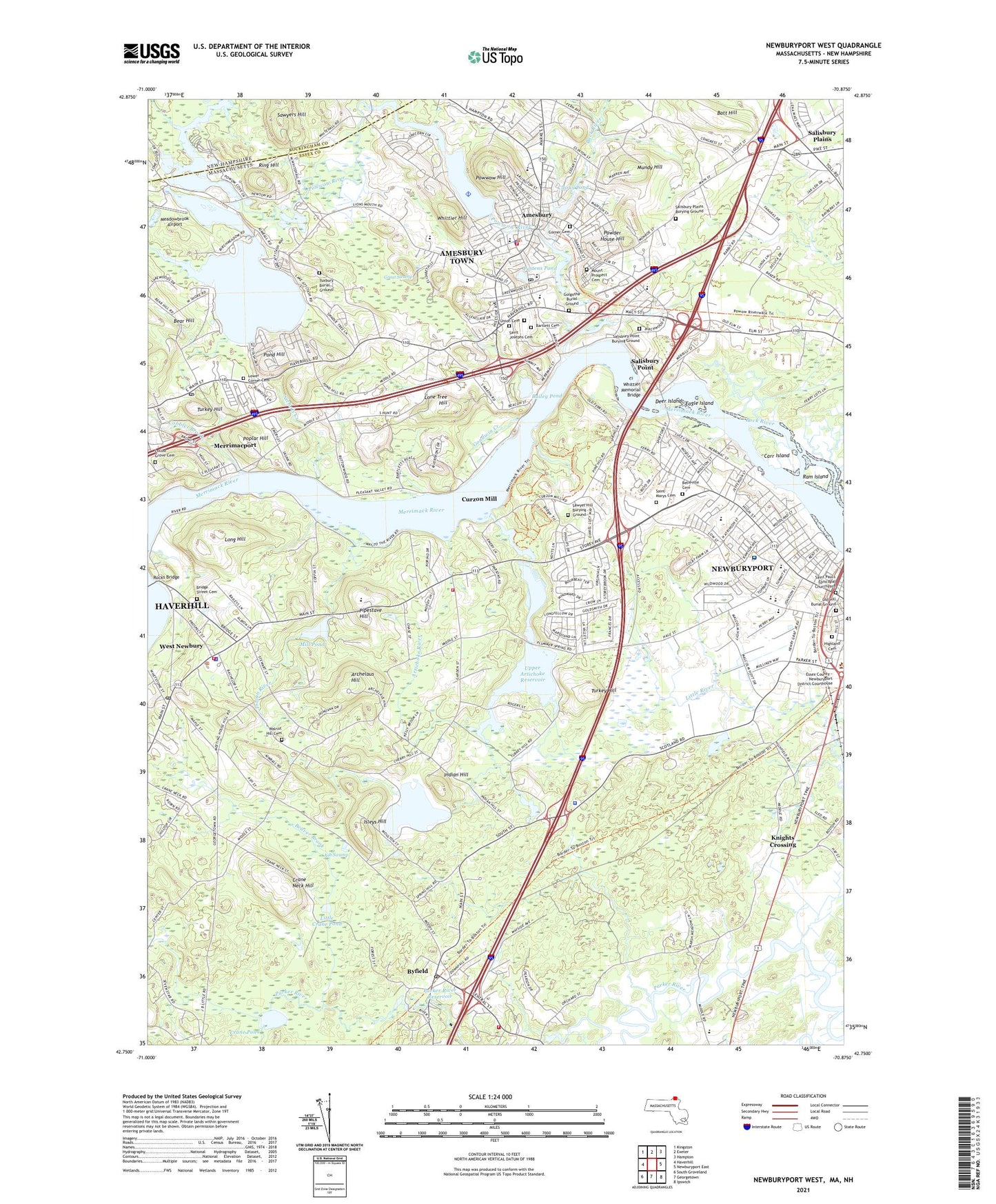
2024 topographic map quadrangle Newburyport West in the states of Massachusetts, New Hampshire. Scale: 1:24000. Based on the newly updated USGS 7.5' US Topo map series, this map is in the following counties: Essex, Rockingham. The map contains contour data, water features, and other items you are used to seeing on USGS maps, but also has updated roads and other features. This is the next generation of topographic maps. Printed on high-quality waterproof paper with UV fade-resistant inks.
Quads adjacent to this one:
West: Haverhill
Northwest: Kingston
North: Exeter
Northeast: Hampton
East: Newburyport East
Southeast: Ipswich
South: Georgetown
Southwest: South Groveland
Contains the following named places: Academy of Strategic Learning HMCS School, All Saints Church, Alliance Park, Amesbury, Amesbury and Salisbury Mills Village Historic District, Amesbury Census Designated Place, Amesbury Country Club, Amesbury Elementary School, Amesbury Fire Department Station 1 Headquarters, Amesbury Health Center Hospital, Amesbury High School, Amesbury High School Library, Amesbury Hospital, Amesbury Industrial Park, Amesbury Middle School, Amesbury Police Department, Amesbury Post Office, Amesbury Public Library, Amesbury Town Hall, Amesbury Town Landing, Amesbury Town Park, Anna Jaques Hospital, Archelaus Hill, Arrowhead Farm, Artichoke Dairy, Artichoke River, Artichoke River Dam, Ash Swamp, Assembly of God Church, Atkinson Common, Atlantic Forest Ski Area, Back River, Bailey Pond, Bailey Pond Dam, Baker Woods, Bartlett Museum, Batchelder Park, Batt Hill, Bear Hill, Beaver Brook, Belleville Cemetery, Belleville School, Bridge Street Cemetery, Byfield, Byfield Fire Department, Byfield Post Office, Byfield School, Byfield Town Hall, Cardinal Cushing Academy, Carr Island, Carr Island State Reservation, Carriage Museum, Cashman Elementary School Library, Cashman Park, Charles C Cashman Elementary School, City of Amesbury Town, City of Newburyport, Clarks Pond, Coastal Educational Collaborative School, Cobbler Brook, Collins Street Playground, Crane Neck Hill, Crane Pond, Cross Roads Plaza Shopping Center, Cross Roads Shopping Plaza, Currier School, Curzon Mill, Davenport School, Deer Island, Dexter Industrial Green, Doctor John C Page School, Downfall Wildlife Management Area, Eagle Island, First Church of Christ Scientist, Francis T Bresnahan Elementary School, Goodwin Creek, Governor Dummer Academy, Grace Reform Baptist Church, Great Swamp, Highland Cemetery, Horace Mann School, Indian Hill, Indian River, Isleys Hill, Kelley School, Knights Crossing, Lake Attitash, Lake Attitash Dam, Lake Gardner, Lake Gardner Dam, Lake Gardner Seaplane Base, Little Crane Pond, Locust Grove Cemetery, Lone Tree Hill, Long Hill, Long Hill Orchard, Lower Artichoke Reservoir, Lower Artichoke Reservoir Dam, Lower Corner Cemetery, Massachusetts State Police Troop A2 Newbury Barracks, Meadowbrook Airport, Merrimac Post Office, Merrimacport, Merrimacport Post Office, Mill Pond, Mill Pond Dam, Mill River, Mount Prospect Cemetery, Mundy Hill, Newbury Town Library, Newburyport, Newburyport City Hall, Newburyport High School, Newburyport High School Library, Newburyport Station, Nichols Creek, Old Newbury Golf Club, Oliver Ames High School, Parker River Dam, Parker River Dam at Central Street, Parker River Reservoir, Pattens Pond, Pipestave Hill, Pond Hill, Poplar Hill, Port Plaza, Powder House Hill, Powwow Hill, Powwow River, Ram Island, Ring Hill, River Valley Charter School, Rocks Bridge, Rogers Medical Library, Rupert A Nock Middle School, Sacred Heart School, Saint Josephs Cemetery, Saint Marys Cemetery, Salisbury Plains, Salisbury Plains Burying Ground, Salisbury Point, Salisbury Point Burying Ground, Salisbury Point Post Office, Sawyer Hill Burying Ground, Sawyers Hill, Sparhawk School, Town Creek, Town of West Newbury, Turkey Hill, Tuxbury Pond, Tuxbury Pond Camping Area, Tuxbury Pond Outlet Dam, Union Cemetery, Upper Artichoke Reservoir, Walnut Hill Cemetery, West Newbury, West Newbury Central School, West Newbury Fire Department Garden Street Station, West Newbury Fire Department Headquarters, West Newbury Police Department, West Newbury Post Office, West Newsbury Post Office, Whittier Hill, Whittier Memorial Bridge, Whittier Rehabilitation Hospital, ZIP Codes: 01913, 01922, 01950, 01985