MyTopo
Kingston New Hampshire US Topo Map
Couldn't load pickup availability
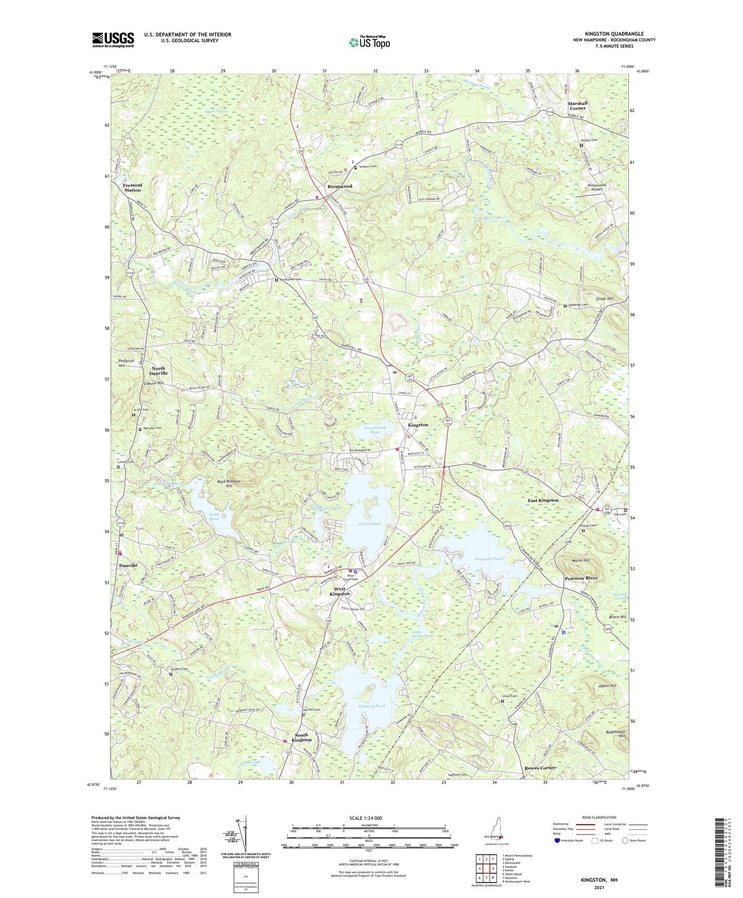
2024 topographic map quadrangle Kingston in the state of New Hampshire. Scale: 1:24000. Based on the newly updated USGS 7.5' US Topo map series, this map is in the following counties: Rockingham. The map contains contour data, water features, and other items you are used to seeing on USGS maps, but also has updated roads and other features. This is the next generation of topographic maps. Printed on high-quality waterproof paper with UV fade-resistant inks.
Quads adjacent to this one:
West: Sandown
Northwest: Mount Pawtuckaway
North: Epping
Northeast: Newmarket
East: Exeter
Southeast: Newburyport West
South: Haverhill
Southwest: Salem Depot
This map covers the same area as the classic USGS quad with code o42071h1.
Contains the following named places: Aspen Hill, Bartlett Brook, Boy Scout Camp, Brentwood, Brentwood Cemetery, Brentwood Fire Department, Brentwood Police Department, Camp Lincoln, Cedar Swamp Pond, Center Cemetery, Coburn Hill, Colby Brook, Colby Memorial Library, Country Pond, Country Shore Camping Area, Daniel J Bakie Elementary School, Daniel J Bakie Preschool, Danville, Danville Camping Area, Danville Cemetery, Danville Fire Department, Danville Police Department, Danville Post Office, Dudley Cemetery, Dustin Pond Dam, East Kingston, East Kingston Fire Department, East Kingston Methodist Church, East Kingston Police Dept, East Kingston Post Office, Eaton School, Exeter River Camping Area, Exeter River Reservoir, First Universalist Church, Fremont Station, Great Hill, Great Pond, Greenwood Pond, Halfmoon Pond, Hampstead Village Preschool, Hillside Cemetery, Kingston, Kingston Childrens Center, Kingston Fire Department, Kingston Fire Department Substation, Kingston Police Dept, Kingston Post Office, Kingston State Park, Kingston Town Hall, Lighthouse Christian Academy, Little River, Long Pond, Long Pond Dam, Marshall Corner, Mary E Bartlett Memorial Library, Mill Hill Cemetery, Morse Hill, Nichols Memorial Library, North Danville, Old Cemetery, Pages Corner, Philbrick Hill, Pickpocket Dam, Pilgrim United Church of Christ, Pine Grove Cemetery, Powwow Pond, Powwow River, Pow-Wow Seaplane Base, Richard Sargent Management Area, Rock Rimmon Hill, Rock Rimmon State Forest, Rockingham County, Rowes Corner, Sanborn Cemetery, Sanborn Regional High School, Sanborn School, Seacoast Charter School, Soldiers Cemetery, South Kingston, Spruce Swamp, Swasey Central School, Town of Brentwood, Town of Danville, Town of East Kingston, Town of Fremont, Town of Kingston, Trickling Falls Dam, Union Cemetery, Wadleigh Cemetery, Webster Natural Area, West Kingston, Winterwood Airport, Ye Old Cemetery, Ye Olde Meeting House, ZIP Codes: 03819, 03848