MyTopo
Norwood Massachusetts US Topo Map
Couldn't load pickup availability
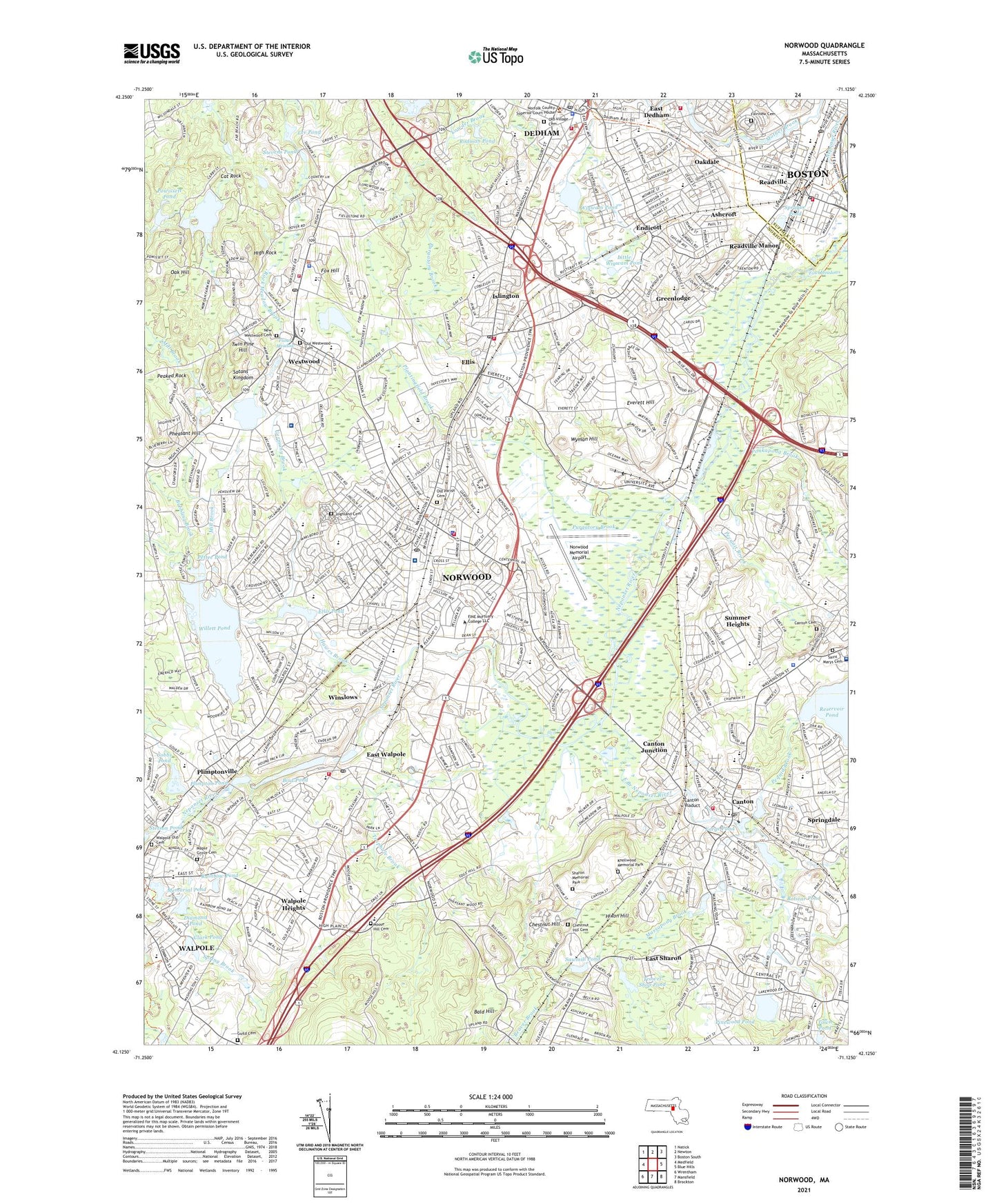
2024 topographic map quadrangle Norwood in the state of Massachusetts. Scale: 1:24000. Based on the newly updated USGS 7.5' US Topo map series, this map is in the following counties: Norfolk, Suffolk. The map contains contour data, water features, and other items you are used to seeing on USGS maps, but also has updated roads and other features. This is the next generation of topographic maps. Printed on high-quality waterproof paper with UV fade-resistant inks.
Quads adjacent to this one:
West: Medfield
Northwest: Natick
North: Newton
Northeast: Boston South
East: Blue Hills
Southeast: Brockton
South: Mansfield
Southwest: Wrentham
This map covers the same area as the classic USGS quad with code k42071b1.
Contains the following named places: A-Copy Heliport, Ames Junior High School, Ames Schoolhouse, Ashcroft, Avery School, Balch Elementary School, Bald Hill, Beaver Brook, Beaver Meadow Brook, Bernstein Farm Pond Dam, Bird Middle School, Bird Pond, Bird Pond Dam, Blackburn Memorial Park, Blessed Sacrament Elementary School, Blue Hill Country Club, Blue Hills Reservation, Bolivar Pond, Bolivar Pond Dam, Bubbling Brook, Buckmaster Pond, Cantion Junction Station, Canton, Canton Cemetery, Canton Center Station, Canton High School, Canton Junction, Canton Viaduct, Capen School, Cat Rock, Charles J Prescott School, Chestnut Hill, Chestnut Hill Cemetery, Clark Pond, Cobbs Pond, Cornelius M Callahan School, Dean S Luce School, Dean Street Shopping Center, Dedham, Dedham Census Designated Place, Dedham Corporate Center Station, Dedham High School, Dedham Junior High School, Dedham Mall, Dedham Mall Shopping Center, Dedham Middle School, Dedham Plaza, Dedham Plaza Shopping Center, Dedham Station, Deerfield School, Dexter School, Diamond Pond, Downey School, E W Thurston Middle School, E. W. Thurston Middle School, East Branch Neponset River, East District School, East Sharon, East Walpole, Eliot Park, Eliot School, Ellis, Ellis Gardens Playground, Ellis Pond, Ellis Pond Dam, Endean Playground, Endicott, Endicott Station, Everett Hill, F A Cleveland School, Fairview Cemetery, Fisher Meadow, Fisher School, Forge Pond, Forge Pond Dam, Fowl Meadows, Fox Hill, Francis William Park, Germany Brook, Governor Edward Winslow School, Greenlodge, Greenlodge School, Guild Cemetery, Hawes Brook, Heartland Plaza Shopping Center, Helen Hansen Elementary School, Hemenway School, High Rock, Highland Cemetery, Hixon Hill, Hyde Park, Islington, Islington High School, Islington Station, John F Kennedy School, John P Oldham School, Knollwood Memorial Park, Lechmere Sales Shopping Center, Lee Pond, Legion Park, Lieutenant Peter M Hansen School, Little Wigwam Pond, Lowder Brook, Main Street Shopping Center, Maple Grove Cemetery, Market Place Shopping Center, Martha Jones School, Massachusetts Hospital School, Massachusetts State Hospital School, Massapoag Brook, McAleer Playground, Memorial Field, Memorial Pond, Mill Brook, Moose Hill Cemetery, Nahatan Street Shopping Center, Noannet Pond, Noannet Pond Dam, Norfolk County, Norfolk County Agricultural School, Norfolk Golf Club, Norwod Junior High School North, Norwood, Norwood Census Designated Place, Norwood Central Station, Norwood Depot Station, Norwood High School, Norwood Hospital, Norwood Industrial Park, Norwood Junior High School, Norwood Junior High School North, Norwood Junior High School South, Norwood Memorial Airport, Norwood Plaza, Norwood Plaza Shopping Center, Oak Hill, Oakdale, Oakdale School, Old Parish Cemetery, Old Past Road School, Oldham School, Park Place Industrial Park, Paul Hanlon School, Peaked Rock, Pecunit Brook, Pequid Brook, Pequtside Farm, Pettee Pond, Pheasant Hill, Pinewood Pond, Plantingfield Brook, Pleasant Park, Plimpton Pond, Plimpton Pond Dam, Plimpton School, Plimptonville, Plimptonville Station, Pond Plain School, Ponkapoag Brook, Powissett Pond, Puffers Brook, Purgatory Brook, Rainbow Pond, Readville, Readville Manor, Readville Station, Revere School, Rodman Pond, Route 1 Industrial Park, Route 128 Station, Saint Annes School, Saint Catherines School, Saint Johns School, Saint Marys Cemetery, Saint Marys School, Satans Kingdom, Sawmill Pond, Sharon Memorial Park, Shattuck Park, Shattuck School, Shawmut Industrial Park, Shephard Pond, Shephard Pond Dam, Southwest Industrial Park, Sprague Pond, Spring Valley Country Club, Springdale, Steep Hill Brook, Stetson Pond, Stevens Pond, Stockwell Ponds, Stoughton Junior High School, Summer Heights, Summer Street Recreation Area, The Village Mall Shopping Center, The Walpole Mall, Town of Canton, Town of Dedham, Town of Norwood, Town of Westwood, Town Pond, Traphole Brook, Trowel Shop Pond, Trowel Shop Pond Dam, Twin Pine Hill, Ursuline Academy, Walpole, Walpole Census Designated Place, Walpole East Junior High School, Walpole Heights, Walpole Old Cemetery, Walpole Shopping Plaza, Weld Pond, Westwood, Westwood High School, Westwood Lodge Hospital, Westwood/128 Plaza, Westwood-128 Plaza Shopping Center, Wiggins Airport, Wigwam Pond, Willett Pond, Willett Pond Dam, Willett School, William E Sheehan School, William H Galvin Middle School, Wilson Street Playground, Windsor Gardens Station, Winslows, WSRB-FM (Walpole), Wyman Hill, ZIP Codes: 02021, 02026, 02032, 02062, 02090