MyTopo
Palmer Massachusetts US Topo Map
Couldn't load pickup availability
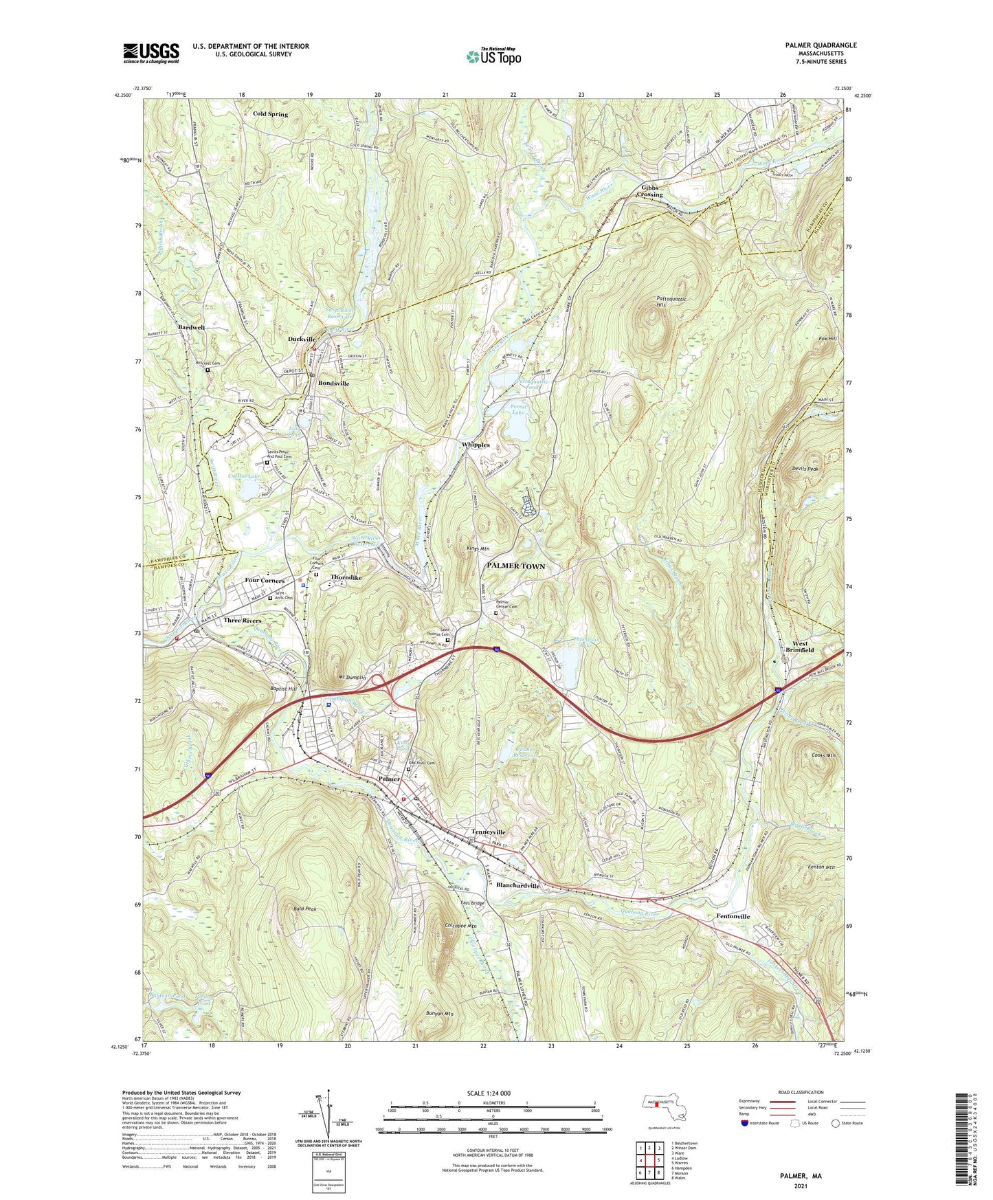
2024 topographic map quadrangle Palmer in the state of Massachusetts. Scale: 1:24000. Based on the newly updated USGS 7.5' US Topo map series, this map is in the following counties: Hampden, Hampshire, Worcester. The map contains contour data, water features, and other items you are used to seeing on USGS maps, but also has updated roads and other features. This is the next generation of topographic maps. Printed on high-quality waterproof paper with UV fade-resistant inks.
Quads adjacent to this one:
West: Ludlow
Northwest: Belchertown
North: Winsor Dam
Northeast: Ware
East: Warren
Southeast: Wales
South: Monson
Southwest: Hampden
This map covers the same area as the classic USGS quad with code o42072b3.
Contains the following named places: Bald Peak, Baldwin Pond, Baldwin Pond Dam, Baptist Hill, Bardwell, Baystate Wing Hospital, Beaver Brook, Big Y Plaza, Blanchardville, Blodgett Mill Brook, Bondsville, Bondsville Census Designated Place, Bondsville Fire Department, Bondsville Lower Dam, Bondsville Post Office, Bottle Brook, Bunyan Mountain, Chicopee Brook, Chicopee Mountain, City of Palmer Town, Cold Spring, Converse Middle School, Converse Middle School Library, Cooks Mountain, Crystal Lake, Devils Peak, Duckville, Dumplin Brook, Faith Baptist Christian Academy, Faith Baptist Church, Fays Bridge, Fenton Mountain, Fentonville, Flat Brook, Forest Lake, Forest Lake Dam, Foskett Mill Stream, Four Corners, Four Corners Cemetery, Fox Hill, Franklin Street School, Freitag Pond, George Washington Plaza, George Washington Plaza Shopping Center, Gibbs Crossing, Hillcrest Cemetery, Jabish Brook, Kings Brook, Kings Mountain, Knox Pond, Lilly Pond, Mapletree Industrial Center, Massachusetts State Hospital, Meadowbrook Green, Metropolitan Airport, Mount Dumplin, New Birth Christian Church, Oak Knoll Cemetery, Old Mill Pond Elementary School, Old Mill Pond School Library Media Center, Palmer, Palmer Ambulance Service, Palmer Census Designated Place, Palmer Center, Palmer Center Cemetery, Palmer Fire Department, Palmer Green Estates, Palmer High School, Palmer Industrial Park, Palmer Medical Center, Palmer Police Department, Palmer Post Office, Palmer Public Library, Palmer Reservoir, Palmer Reservoir Upper Dam, Pathfinder Regional Vocational Technical High School, Pattaquattic Hill, Pattaquattic Pond, Penny Brook, Pulaski Park, Quaboag River, Saint Anns Cemetery, Saint Thomas Cemetery, Saints Peter and Paul Cemetery, Saints Peter and Paul School, Sovereign Grace Baptist Church, Swift River Reservoir, Tenneyville, Textile Printing Company Upper Dam, Thompson Lake, Thompson Lake Dam, Thorndike, Thorndike Post Office, Three Rivers, Three Rivers Census Designated Place, Three Rivers Fire Department, Three Rivers Post Office, Turkey Brook, Unitarian Universalist Church, Ware River, Ware River Dam, Ware River Reservoir, West Brimfield, Whipples, ZIP Codes: 01009, 01069, 01079, 01080