MyTopo
Pittsfield West Massachusetts US Topo Map
Couldn't load pickup availability
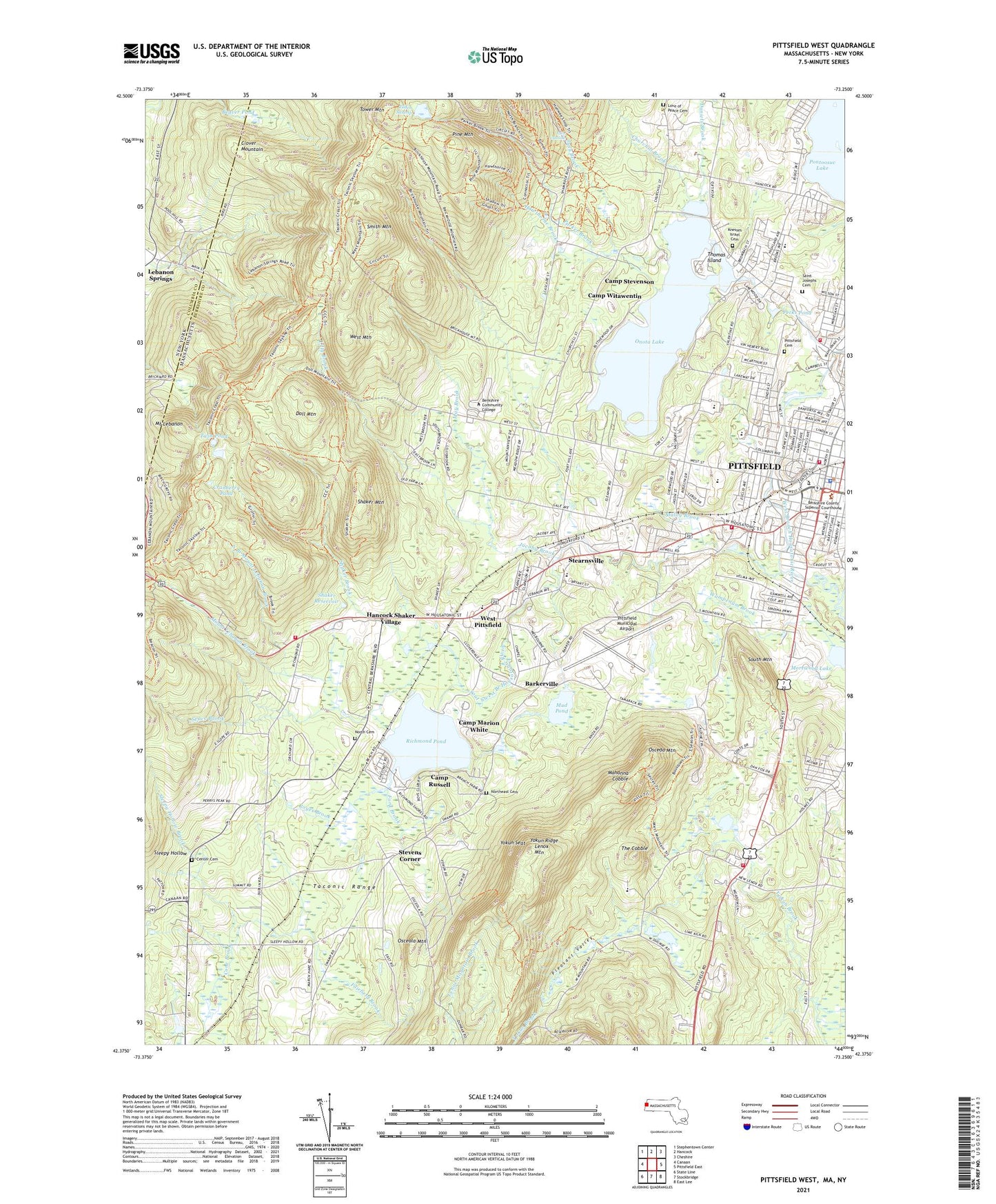
2024 topographic map quadrangle Pittsfield West in the states of Massachusetts, New York. Scale: 1:24000. Based on the newly updated USGS 7.5' US Topo map series, this map is in the following counties: Berkshire, Columbia. The map contains contour data, water features, and other items you are used to seeing on USGS maps, but also has updated roads and other features. This is the next generation of topographic maps. Printed on high-quality waterproof paper with UV fade-resistant inks.
Quads adjacent to this one:
West: Canaan
Northwest: Stephentown Center
North: Hancock
Northeast: Cheshire
East: Pittsfield East
Southeast: East Lee
South: Stockbridge
Contains the following named places: Abby Lodge School, Barkerville, Bartlett's Orchard, Bates Memorial State Park, Beaver Pond, Berkshire Athenaeum, Berkshire Common Shopping Center, Berkshire Community College, Berkshire County Courthouse, Berkshire Downs, Berkshire Law Library, Berkshire Medical Center Hillcrest Campus, Berkshire Museum, Berkshire Nursing Home, Berkshire Public Theater, Bousquet Ski Area, Brickhouse Mountain Trail, Briggs School, Burbank Park, Camp Marion White, Camp Russell, Camp Stevenson, Camp Witawentin, Catamount Ski Area, Center Cemetery, Childrens Museum of the Berkshires, Churchill Brook, City of Pittsfield, Clapp Park, Clover Mountain, Coolidge Playground, Cornerstone Baptist Church, County Ambulance Service, Cranberry Pond, Crosby Junior High School, Daniels Brook, Doll Mountain, East Branch Housatonic River, Evangelical Free Church, Fairfield Brook, First Baptist Church, First Church of Christ Congregational, First Church of Christ Scientist, First United Methodist Church, Ford Brook, Hancock Fire Department Station 2, Hancock Shaker Village, Hancock Shaker Village Library, Hawthorne Brook, Highland Elementary School, Housatonic Academy, Jacobs Ladder Ministry, Jacoby Brook, Jonathan Edwards Library, Knesses Israel Cemetery, Lake Onota Village Park, Lenox Country Shops Shopping Center, Lenox Fire Department New Lenox Station, Lenox House Country Shops, Lenox House Country Shops Shopping Center, Lenox Mountain, Lichtenstein Center for the Arts, Lilly Brook, Love of Peace Cemetery, Lower Barkerville Post Office, Lower Pecks Pond Dam, Lulu Brook, Lulu Cascade, Mahanna Cobble, Maloy Brook, May Brook, Memorial Park, Morewood Lake, Mount Lebanon, Mount Lebanon Brook, Mud Pond, New Life Community Fellowship Church, North Branch Mount Lebanon Brook, North Cemetery, Northeast Cemetery, Old Central Fire Station, Onota Brook, Onota Lake, Onota Lake Dam, Osceda Mountain, Osceola Mountain, Osceola Park, Park Square Historic District, Parker Brook, Pecks Pond, Pilgrim Memorial Church, Pine Mountain, Pittsfield Cemetery, Pittsfield City Hall, Pittsfield Country Club, Pittsfield Fire Department Engine 1, Pittsfield Fire Department Engine 5, Pittsfield Fire Department Headquarters, Pittsfield Municipal Airport, Pittsfield Plaza Shopping Center, Pittsfield Police Department, Pittsfield State Forest, Pittsfield Vocational School, Pleasant Valley, Pleasant Valley Sanctuary, Pomeroy School, Pontoosuc Lake Country Club, Pontoosuc Park, Redfield School, Reigning Love Church, Richmond Consolidated School, Richmond Police Department, Richmond Pond, Royes Brook, Saint George Greek Orthodox Church, Saint Joseph Central High School Library, Saint Josephs Cemetery, Saint Josephs High School, Saint Marks Middle School, Saint Mark's Middle School, Saint Nicholas Orthodox Church, Saint Stephens Episcopal Church, Saint Teresa Church, Seace Brook, Second Congregational Church, Shaker Brook, Shaker Mountain, Shaker Reservoir, Shops at Brushwood Farms Shopping Center, Silvio O Conte Community School, Sleepy Hollow, Sleepy Hollow Brook, Smith Brook, Smith Mountain, South Congregational Church, South Mountain, Southwest Branch Housatonic River, Stearns School, Stearnsville, Stevens Corner, Tabernacle Baptist Church, Taconic High School, Taconic High School Resource Center, Taconic Range, Taconic Skyline Trail, The Center at Lenox, The Center at Lenox Shopping Center, The Cobble, The Pittsfield Plaza, Thomas Island, Tilden Swamp, Tower Mountain, Town of Richmond, Tracy Brook, Tucker School, Turner Trail, Twin Pond, Unitarian Church, Wahcohah Park, Wahconah Street Greenhouses, Wampenum Brook, WBEC-AM (Pittsfield), WBEC-FM (Pittsfield), West Branch Housatonic River, West Mountain, West Pittsfield, West Side Community School, Word of Life Church, WRCZ-FM (Pittsfield), WTBR-FM (Pittsfield), WUHN-AM (Pittsfield), WUPE-FM (Pittsfield), WVUW-TV (Pittsfield), Yokun Ridge, Yokun Seat, ZIP Codes: 01201, 01254