MyTopo
Rowe Massachusetts US Topo Map
Couldn't load pickup availability
Also explore the Rowe Forest Service Topo of this same quad for updated USFS data
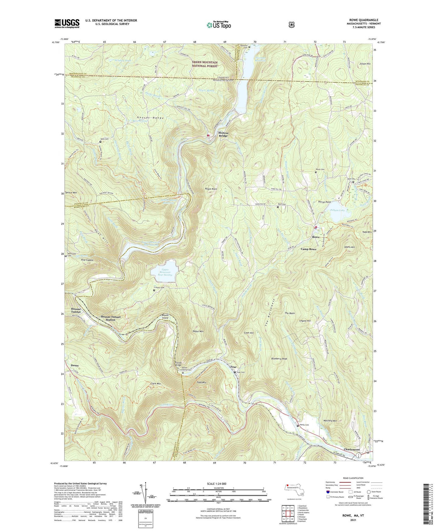
2024 topographic map quadrangle Rowe in the states of Massachusetts, Vermont. Scale: 1:24000. Based on the newly updated USGS 7.5' US Topo map series, this map is in the following counties: Franklin, Berkshire, Bennington, Windham. The map contains contour data, water features, and other items you are used to seeing on USGS maps, but also has updated roads and other features. This is the next generation of topographic maps. Printed on high-quality waterproof paper with UV fade-resistant inks.
Quads adjacent to this one:
West: North Adams
Northwest: Stamford
North: Readsboro
Northeast: Jacksonville
East: Heath
Southeast: Ashfield
South: Plainfield
Southwest: Windsor
Contains the following named places: Adams Mountain, Bear Swamp, Bear Swamp Pumped Storage - Upper Dam, Bear Swamp Pumped Storage Lower Dam, Beaver Island, Black Brook, Blueberry Peak, Bozrah Brook, Browns Pond, Camp Rowe, Cascade Brook, Charlemont Post Office, Charlemont Village Historic District, Chickley River, Clark Mountain, Cold River, Community Bible Church, Coon Hill, County Brook, Deerfield River Reservoir, Drury, Dunbar Brook, Dunbar Brook Dam, Dunbar Brook Reservoir, Dunbar Brook Trail, East Cemetery, Fife Brook, Florida Bridge, Fort Pelham, Gulf Brook, Haley Brook, Hawks Cemetery, Heywoods Station, Hoosac Tunnel, Hoosac Tunnel Station, Hunt Brook, Hunt Hill, Jillson Hill, Legate Hill, Legate Hill Brook, Logan Station, Lord Brook, Lower Reservoir Bear Swamp, Manning Brook, Martha's Vineyard State Forest, Monroe Bridge, Monroe Bridge Post Office, Monroe Fire Department, Negus Mountain, Nelson Family Cemetery, New England Power Company Number 5, North Cemetery, Paint Brook, Parsonage Brook, Patch Brook, Pelham Brook, Pelham Lake, Pelham Lake Dam, Pelham Lake Park, Percys Point, Phelps Brook, Pine Cobble, Potter Brook, Pulpit Rock, Reed Brook, Rice Brook, Rowe, Rowe Camp, Rowe Elementary School, Rowe Fire Department, Rowe Police Department, Rowe Post Office, Roycroft Lookout, Sam Rice Brook, Sherman Cemetery, Sherman Dam, Sherman Reservoir, Shippee Brook, Smith Brook, South Branch Deerfield River, Steele Brook, Tannery Brook, Tatro Brook, Taylor Brook, The Basin, The Northwest, Todd Brook, Todd Mountain, Tower Brook, Town of Monroe, Town of Rowe, Trail Head Picnic Area, Trout Brook, Tuttle Brook, Upper Reservoir Bear Swamp, Warfield Mountain, West Cemetery, Wheeler Brook, Whitcomb Brook, Windsor Pond, Yankee Atomic Powerplant, Zoar, Zoar Cemetery, ZIP Codes: 01343, 01350, 01367