MyTopo
Southwick Massachusetts US Topo Map
Couldn't load pickup availability
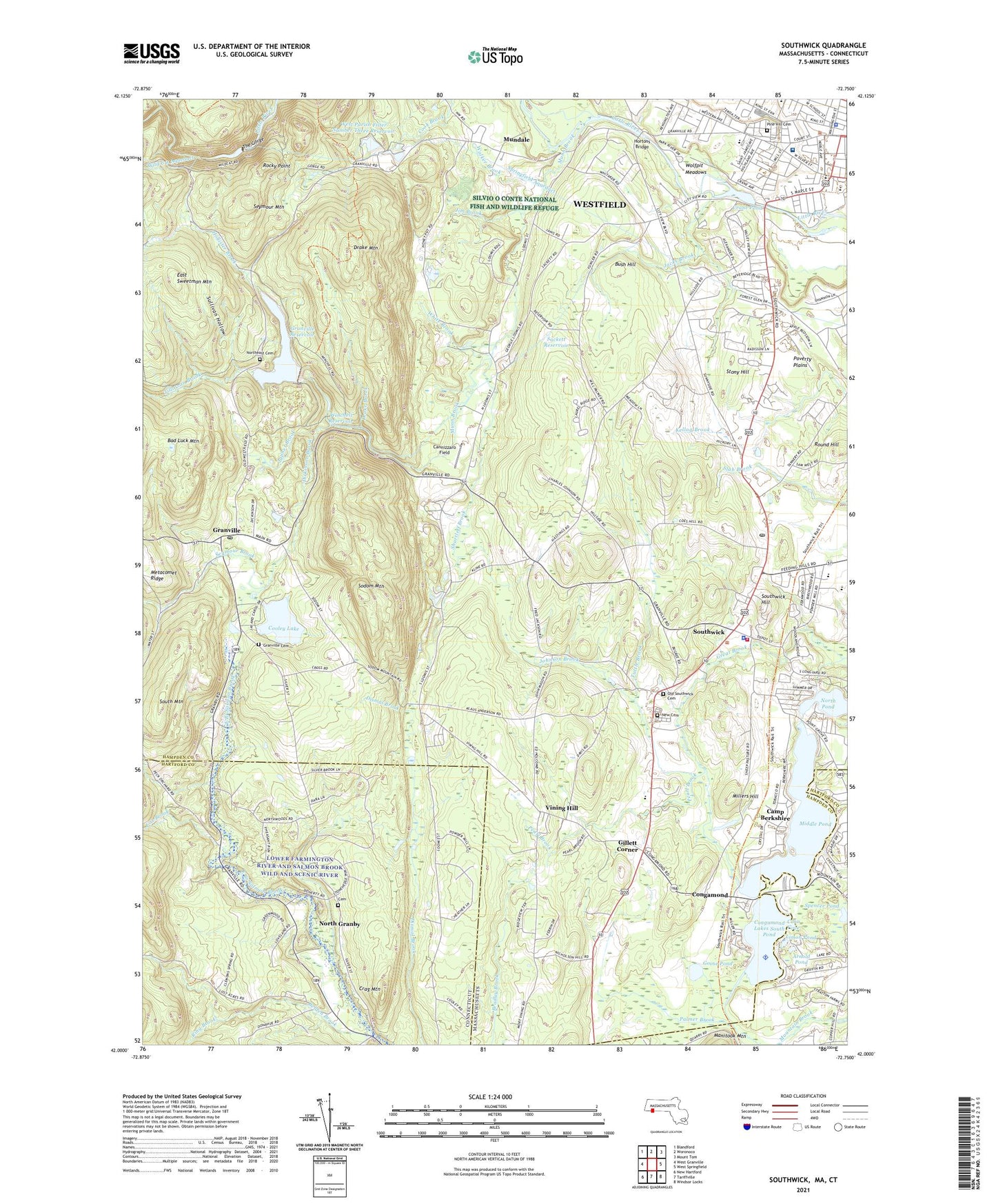
2024 topographic map quadrangle Southwick in the states of Massachusetts, Connecticut. Scale: 1:24000. Based on the newly updated USGS 7.5' US Topo map series, this map is in the following counties: Hampden, Hartford. The map contains contour data, water features, and other items you are used to seeing on USGS maps, but also has updated roads and other features. This is the next generation of topographic maps. Printed on high-quality waterproof paper with UV fade-resistant inks.
Quads adjacent to this one:
West: West Granville
Northwest: Blandford
North: Woronoco
Northeast: Mount Tom
East: West Springfield
Southeast: Windsor Locks
South: Tariffville
Southwest: New Hartford
This map covers the same area as the classic USGS quad with code k42072a7.
Contains the following named places: Abner Gibbs School, Advent Christian Church, Alexander H. Prew Library Media Center, Allen Park, Ames-Big Y Shopping Center, Arnold Pond, Babbs Beach, Babbs Beach Recreation Area, Bad Luck Mountain, Baystate Noble Hospital, Belden Brook, Bush Hill, Camp Berkshire, Cannizzaro Field, Carson Pond, Christ Lutheran Church, Christian Church of God, Church of the Atonement, Congamond, Congamond Lake Heliport, Congamond Lakes, Congamond Lakes Middle Dike, Congamond Lakes Middle Pond, Congamond Lakes North Dike, Congamond Lakes South Dike, Congamond Lakes South Pond, Conn Cove, Consolidated School, Cooley Lake, Cooley Lake Dam, Crag Mountain, Crane Pond, Dickinson Brook, Drake Brook, Drake Mountain, East Sweetman Mountain, Edgewood Golf Course, First United Methodist Church, Fox Brook, Gillett Corner, Golden Acres Campground, Goose Pond, Granville, Granville Cemetery, Granville Post Office, Granville Reservoir, Granville Reservoir Dam, Granville Village School, Highland Elementary School, Holcomb Park, Hollister Brook, Hortons Bridge, Jacks Brook, Japhet Brook, Jim Brook, Johnson Brook, Lady of the Lake Church, Limon Pond, Little River Reservoir, Logie Dam Dropped, Massachusetts State Normal Training School, Middle Pond, Millers Hill, Mountain Brook, Mountain Orchards, Mundale, Mundale Airport, Munn Brook, New Cemetery, North Granby Census Designated Place, North Pond, Northeast Cemetery, Open Arms Child Care Center, Palmer Brook, Pearl Brook, Pine Hill Cemetery, Pitcher Brook, Poverty Plains, Powder Mill School, Ring Brook, Rocky Point, Round Hill, Sackett Reservoir, Saint Johns Lutheran Church, Seymour Brook, Seymour Mountain, Shurtleff Brook, Sodom Mountain, Sodom Mountain Campground, Sodom Mountain Ski Area, South Mountain, South Pond, South Pond Seaplane Base, Southwick, Southwick Assembly of God Church, Southwick Baptist School, Southwick Country Club, Southwick Fire Department, Southwick Hill, Southwick Plaza Shopping Center, Southwick Police Department, Southwick Post Office, Southwick Recreation Center, Southwick Town Hall, Spencer Pond, Springfield Water Works Intake Dam, Springfield Water Works Intake Reservoir, Stevens Paper Company Lower Dam, Stevens Paper Company Upper Dam, Stony Hill, Sullivan Hollow, The Gorge, The Shops at Gillett Corners Shopping Center, Tillotson Brook, Town of Southwick, Trade High School, Trumble Brook, Tuttle Brook, Village Square, Vining Hill, Walker Brook, West Parish Filter Number One Dam, West Parish Filter Number Three Dam, West Parish Filter Number Three Reservoir, West Parish Filter Number Two Dam, West Parish Orchards, Westfield City Hall, Westfield Evangelical Free Church, Westfield Junior High School, Westfield Middle School, Westfield Municipal Building, Westfield Police Department, Westfield Vocational Technical High School, White Brook, Winchell Reservoir, Wolfpit Meadows, Woodland Elementary School, ZIP Codes: 01077, 06060