MyTopo
Monadnock Mountain New Hampshire US Topo Map
Couldn't load pickup availability
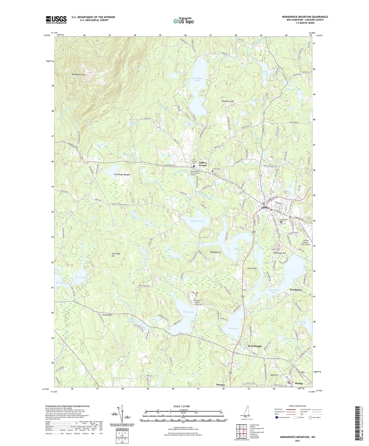
2024 topographic map quadrangle Monadnock Mountain in the state of New Hampshire. Scale: 1:24000. Based on the newly updated USGS 7.5' US Topo map series, this map is in the following counties: Cheshire. The map contains contour data, water features, and other items you are used to seeing on USGS maps, but also has updated roads and other features. This is the next generation of topographic maps. Printed on high-quality waterproof paper with UV fade-resistant inks.
Quads adjacent to this one:
West: Troy
Northwest: Marlborough
North: Dublin
Northeast: Peterborough North
East: Peterborough South
Southeast: Ashburnham
South: Winchendon
Southwest: Royalston
Contains the following named places: Advent Lutheran Church, Camp Pearl, Camp Wa-Klo, Camp Wanoskett, Carter Hill, Cascade Link Trail, Cheshire Pond, Cheshire Pond Dam, Conant Cemetery, Conant High School, Conference Church Camp, Contoocook Lake, Contoocook Lake Dam, Cummings Meadow, Cummings Meadow Dam, Cummings Meadow Reservoir, Cutler Cemetery, Dead Swamp, Farmers Trail, First Congregational Church, Fitchburg Boy Scout Camp, Franklin Pierce University, Franklin Pierce University Fire Department / Emergency Medical Technician Squad, Frost Brook, Frost Pond, Fullam Hill, Garfield Pond, Gilmore Pond, Gilson Pond, Gilson Pond Dam, Hannah Davis-Amos Fortune Graves, Harling Trail, Haven State Park, Hodge Pond, Jaffrey, Jaffrey Airport-Silver Ranch, Jaffrey Census Designated Place, Jaffrey Center, Jaffrey Center Historic District, Jaffrey Fire Department, Jaffrey Grade School, Jaffrey Mills, Jaffrey Police Department, Jaffrey Post Office, Jaffrey Public Library, Jaffrey Rindge Memorial Ambulance, Jaffrey Rindge Middle School, Jock Page Hill, Mead Brook, Melville Academy, Mills Brook, Monadnock Ecocenter, Monadnock Mountain, Monadnock State Park, Monadnock State Park Campground, Monadnock State Park Visitor Center, Mountain Brook, Mountain Brook Dam, Mountain Brook Reservoir, Old Center Cemetery, Parker Pond, Parker Trail, Peabody Hill, Pearly Lake, Pearly Lake Dam, Pool Pond, Poole Reservoir, Red Cross Trail, Rindge, Rindge Fire Department, Rindge Post Office, Rindge Town Police Department, Rugg Pond, Saint Patrick School, Sawyer Tract, Scott Pond, Scott Pond Dam, Stony Brook, Taggart Meadows, Thorndike Pond, Thorndike Pond Dam, Todd Hill, Town of Jaffrey, Town of Rindge, Tyler Brook, Victory High School, West Rindge, Whitcomb Hill, White Arrow Trail, White Dot Trail, Whites Pond, Woodbury Hill, Woodemere Park Campground, Woodmere, ZIP Codes: 03452, 03461