MyTopo
Woronoco Massachusetts US Topo Map
Couldn't load pickup availability
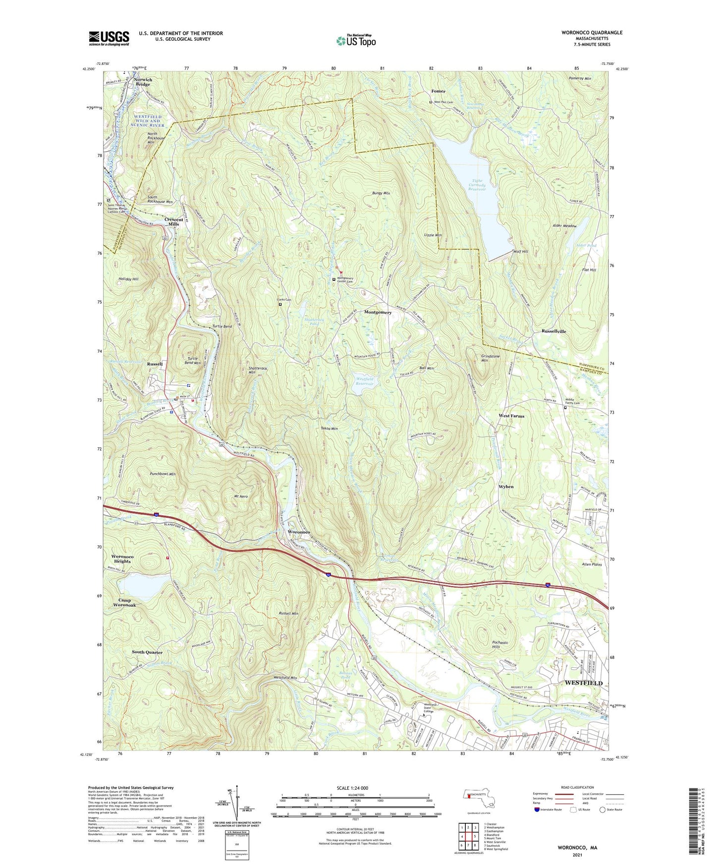
2021 topographic map quadrangle Woronoco in the state of Massachusetts. Scale: 1:24000. Based on the newly updated USGS 7.5' US Topo map series, this map is in the following counties: Hampden, Hampshire. The map contains contour data, water features, and other items you are used to seeing on USGS maps, but also has updated roads and other features. This is the next generation of topographic maps. Printed on high-quality waterproof paper with UV fade-resistant inks.
Quads adjacent to this one:
West: Blandford
Northwest: Chester
North: Westhampton
Northeast: Easthampton
East: Mount Tom
Southeast: West Springfield
South: Southwick
Southwest: West Granville
Contains the following named places: Alder Meadow, Alder Meadow Brook, Alder Pond, Alder Pond Dam, Allen Plains, Appalachian Mountain Club, Ball Mountain, Barnes Pond, Bates Hall, Bearden Brook, Black Brook, Blue Meadow Brook, Border Trail, Bradley Brook, Breakneck Brook, Bungy Mountain, Camp Shepard, Camp Woronoak, Campus Green, Center Cemetery, City of Westfield, Clarks Cemetery, Cook Brook, County Road Trail, Courtney Hall, Crescent Mills, Crescent Mills Dam, Crow Brook, Davis Hall, Dickinson Building, Ely Building, First Interfaith Center, Fisher Trail, Flat Hill, Fomer, Franklin Avenue Elementary School, Grindstone Mountain, Hampton Village, Hilltown Community Ambulance, Holiday Hill, Horse Hill Brook, Juniper Park Elementary School, Lammers Hall, Link Trail, Lizzie Mountain, Massachusetts State Police Station B5 Russell Barracks, Middle Farms Cemetery, Montgomery, Montgomery Church, Montgomery Fire Department, Montgomery Town Hall, Moose Meadow Brook, Moose Meadow Brook Reservoir, Mount Nero, New Intake Reservoir, North Rockhouse Mountain, Norwich Bridge, Parenzo Hall, Pochassic, Pochassic Hills, Pond Brook, Potash Brook, Punchbowl Mountain, Red Brook, Richard Trail, Roaring Brook, Russell, Russell Census Designated Place, Russell Elementary School, Russell Fire Department Station 1 Headquarters, Russell Fire Department Station 2, Russell Mountain, Russell Pond, Russell Pond Dam, Russell Post Office, Russell Reservoir, Russell Town Hall, Russellville, Sacket Brook, Sadle Know Playground, Saint Thomas Aquinas Roman Catholic Cemetery, Scanlon Hall, Shatterack Brook, Shatterack Mountain, Shatterack Pond, Sodom Brook, South Quarter, South Rockhouse Mountain, Stage Brook, Stanley Park, Tekoa Country Club, Tekoa Dam, Tekoa Mountain, Tekoa Reservoir, Tighe Carmody Reservoir, Tighe Carmody Reservoir Dam, Town of Montgomery, Town of Russell, Trainfield, Tucker Brook, Turtle Bend, Turtle Bend Mountain, United Church of Christ, West Branch Westfield River, West Farms, Westfield Alliance Church, Westfield High School, Westfield Mountain, Westfield Reservoir, Westfield Reservoir Dam, Westfield River Paper Company Dam, Westfield River Reservoir, Westfield Sportsmen Club Dam, Westfield State College, Westfield Vocational Technical High School, Westfield Vocational Technical High School Library, Wilson Hall, WNNZ-AM (Westfield), Wolf Hill, Woronoco, Woronoco Heights, Woronoco Mills 29 Ft Dam, Woronoco Mills Dam, WSKB-FM (Westfield), Wyben, Wyben Chapel, ZIP Codes: 01071, 01085, 01086, 01097