MyTopo
Hastings Michigan US Topo Map
Couldn't load pickup availability
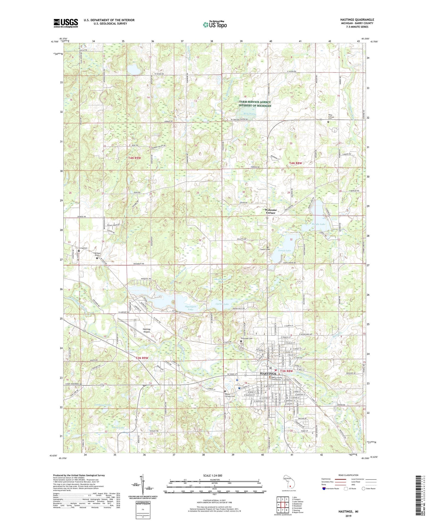
2023 topographic map quadrangle Hastings in the state of Michigan. Scale: 1:24000. Based on the newly updated USGS 7.5' US Topo map series, this map is in the following counties: Barry. The map contains contour data, water features, and other items you are used to seeing on USGS maps, but also has updated roads and other features. This is the next generation of topographic maps. Printed on high-quality waterproof paper with UV fade-resistant inks.
Quads adjacent to this one:
West: Middleville
Northwest: Alto
North: Freeport
Northeast: Lake Odessa
East: Woodland
Southeast: Maple Grove
South: Dowling
Southwest: Cloverdale
This map covers the same area as the classic USGS quad with code o42085f3.
Contains the following named places: Algonquin Lake, Algonquin Lake Church, Algonquin Lake School, Algonquin Lake Trailer Court, Altoff School, Assembly of God Church, Barry County Courthouse, Barry County Sheriff's Office, Bear Hole Lake, Bible Missionary Church, Bird Drain, Bob King Park, Bullhead Drain, Butler Creek, Carlton, Carlton Center Post Office, Carlton Township Hall Historical Marker, Carter Lake, Central School Auditorium Historical Marker, Central School Historical Marker, Charter Township of Rutland, Chidester School, Church of Christ, Church of Jesus Christ of Latter Day Saints, Church of the Nazerene, City of Hastings, Early Hastings Historical Marker, Emmanuel Episcopal Church, Faith Church, Fall Creek, Family Tree Medical Associates, First Baptist Church of Hastings, First Presbyterian Church, First United Methodist Church, First Ward Park, Fish Hatchery Park, Free Methodist Church, George W Lowry House Historical Marker, Governor Kim Sigler Historical Marker, Grace Church, Grace Lutheran Church, Gun Ridge Golf Course, Hastings, Hastings Airport, Hastings Apostolic Tabernacle Church, Hastings Center School, Hastings Country Club, Hastings Fire Department, Hastings High School, Hastings Internal Medicine Associates, Hastings Middle School, Hastings Mutual Insurance Company Historical Marker, Hastings Police Department, Hastings Post Office, Hastings Public Library, Hastings Seventh Day Adventist School, Ingraham Grave, Irving Cemetery, Jones School, Kingdom Hall of Jehovah's Witnesses, Laubaugh Lake, Leach Grave, Leach Lake, Little Brick School, Mercy Ambulance Service Hastings, Merlino's Hidden Valley Estates Mobile Home Park, Methodist Episcopal Church Historical Marker, Middle Lake, Mount Calvary Cemetery, North Irving Church, North Irving Post Office, Northeastern School, Pennock Hospital, Purdy Lake, Railroad Depot Historical Marker, Riverbend Golf Course, Riverside Cemetery, Rogers School, Saint Andrew and Matthias Anglican Church, Saint Rose Catholic Church, Saint Rose Catholic School, Second Ward Park, Seventh-Day Adventist Church, Southeastern School, Striker House Historical Marker, Sugarbush Lake, Township of Carlton, Township of Irving, Tyden Park, WBCH-AM (Hastings), WBCH-FM (Hastings), Welcome Corner, Welcome Corners United Methodist Church, Welcome Woods Campground, West Carlton Cemetery, Willow Marsh Drain, Wood School, Yeckley School, ZIP Code: 49058