MyTopo
Mayfield Michigan US Topo Map
Couldn't load pickup availability
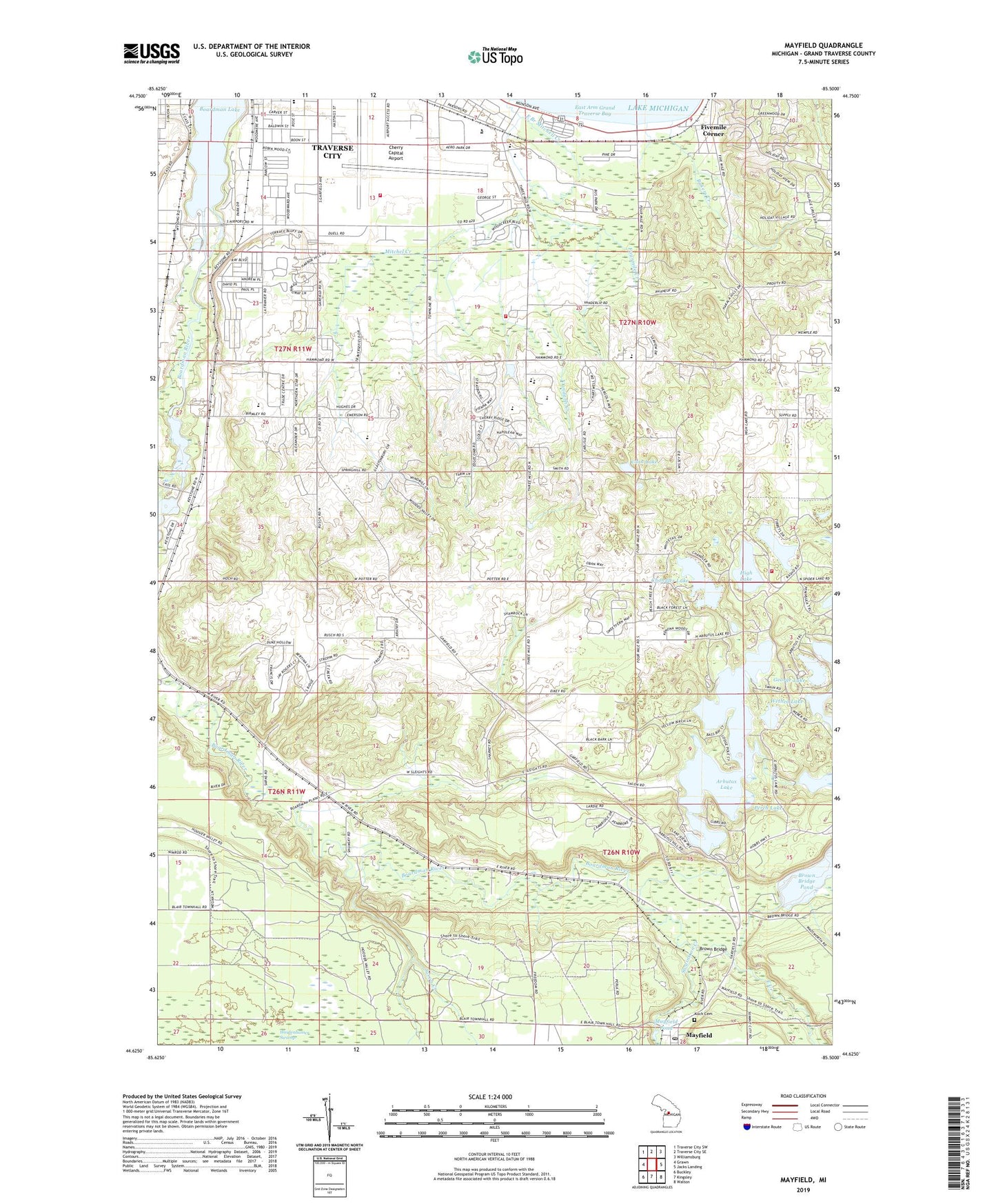
2023 topographic map quadrangle Mayfield in the state of Michigan. Scale: 1:24000. Based on the newly updated USGS 7.5' US Topo map series, this map is in the following counties: Grand Traverse. The map contains contour data, water features, and other items you are used to seeing on USGS maps, but also has updated roads and other features. This is the next generation of topographic maps. Printed on high-quality waterproof paper with UV fade-resistant inks.
Quads adjacent to this one:
West: Grawn
Northwest: Traverse City SW
North: Traverse City SE
Northeast: Williamsburg
East: Jacks Landing
Southeast: Walton
South: Kingsley
Southwest: Buckley
This map covers the same area as the classic USGS quad with code o44085f5.
Contains the following named places: All Seasons Village Shopping Center, Arbutus Court Park, Arbutus Lake, Arbutus Number Four State Forest Campground, Bakers Creek, Barlow Post Office, Beitner Park, Birchwood Nursing Center, Birmley School, Black School, Boardman Lake, Boardman River Scenic Overlook, Boon Street Park, Brown Bridge, Brown Bridge Pond, Camp Haza Witke, Chandler Lake, Cherry Capital Airport, Cherry Knoll School, Cherryland Center Mall, Cherryland Mobile Home Park, Christ United Methodist Church, Church of God, Church of the Living God, Community Church of Christ, Coon Lake, Courtade School, East Bay Ambulance, East Bay Branch Library, East Bay Calvary Church, East Bay Post Office, East Bay School Number 15, East Bay Township Hall, East Branch Mitchell Creek, East Creek, East Junior High School, Elmbrook Golf Course, Fellowship Church, Fivemile Corner, Forest Lake Park, Fourmile Creek, George Lake, Grace McDonald Park, Grand Traverse Academy, Grand Traverse County, Grand Traverse Metro Fire Department Station 1, Grand Traverse Metro Fire Department Station 9, Haney School, High Lake, Hillside Shopping Center, Jaxon Creek, Kelly Park, Killingsworth Park, King's Court Mobile Home Park, Koch Cemetery, Ladies Library Building Historical Marker, Mayfield, Mayfield Pond, Mayfield Post Office, Mayfield Station, Medalie Park, Michigan Department of Natural Resources Traverse City Field Office, Mitchel Creek, Mitchell Creek Golf Course, Mount Holiday Ski Area, North Flight Aero Med, North Flight Hangar, Open Door Fellowship Church, Orchard Church, Perch Lake, Potter School, Sabin Dam, Sabin Pond, Saint Elizabeth Ann Seton Middle School, Seventh Day Adventist Church, Seventh Day Adventist School, Slights Post Office, Slights School, Slights Station, Spring Lake, Swainston Creek, Tibbets Lake, Town and Country Mobile Village, Township of East Bay, Traverse Bay Christian School, Traverse Bay Mennonite Church, Traverse Bay Mennonite School, Traverse City Fire Department Aircraft Rescue Fire Fighting Station, Traverse City High School, Traverse City State Park, Traverse City State Park Campground, Traverse Health Clinic, Traverse Heights School, United Church of Traverse City, Vandarli Creek, Veterans Administration Medical Center, Victory Hill Church, Weidenhamer Swamp, Wethea Lake, Woodcreek Mobile Home Park, ZIP Code: 49686