MyTopo
Rockwood Michigan US Topo Map
Couldn't load pickup availability
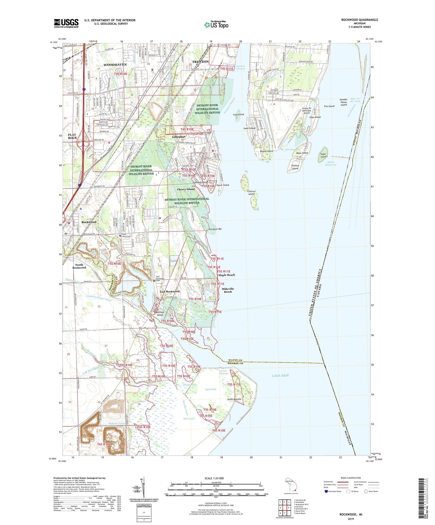
2023 topographic map quadrangle Rockwood in the state of Michigan. Scale: 1:24000. Based on the newly updated USGS 7.5' US Topo map series, this map is in the following counties: Wayne, Monroe. The map contains contour data, water features, and other items you are used to seeing on USGS maps, but also has updated roads and other features. This is the next generation of topographic maps. Printed on high-quality waterproof paper with UV fade-resistant inks.
Quads adjacent to this one:
West: Flat Rock
Northwest: Flat Rock NE
North: Wyandotte
Northeast: Wyandotte OE E
East: Rockwood OE E
South: Estral Beach
Southwest: Stony Point
This map covers the same area as the classic USGS quad with code o42083a2.
Contains the following named places: Bancroft Noles Drain, Barrow School, Bathgate Drain, Battle of Brownstown Historical Marker, Beaumont Hospital - Trenton, Bob-Lo Boat Dock, Brownstown Creek, Brownstown Township Fire Department Station 2, Brownstown Township Fire Department Station 3, Calf Island, Carlson High School, Cass Drain, Celeron Island, Chapman Drain, Charter Township of Brownstown, Cherry Island, City of Gibraltar, City of Rockwood, Clee Drain, Crystal Bay, Damark Marina, Deland G Mercure Memorial Park, Detroit River, Detroit River Historical Marker, Detroit River Recovery Historical Marker, Downriver High School, East Lead, East Rockwood, East Rockwood Cemetery, Edmond Island, Elba Island, Elba Mar Boat Club, Faith Chapel, Fored Yacht Club, Fort-Allen Park, Fox Island, Frank and Poet Drain, Frank E Weiss Elementary School, Frenchman Creek, Gibraltar, Gibraltar Bay, Gibraltar Cemetery, Gibraltar Early Child Education Center, Gibraltar Police Department, Gibraltar Post Office, Gibraltar Public Safety Department Fire Station, Gibralter City Hall, Groh Drain, Grosse Ile Country Club, Grosse Ile Municipal Airport, Grosse Ile Township Hall, Headquarters Pointe Mouille State Game Area, Hickory Island, Hole-in-the-Wall, Horse Island, Humbug Marina, Huron River, Huron River Mobile Home Park, Jefferson School, Lake Erie Metropark, Lake Erie Metropark Golf Course, Lake Erie Metropark Harbor of Refuge, Lake Erie Metropark Marina, Laudenschlager Drain, Lions Park, Livingstone Channel, Lower Constitution Park, Maple Beach, Marsh Creek, Meso Island, Military Outpost 1815-1817 Historical Marker, Milleville Beach, Millman Island, Morrison Drain, Mouille Creek, Mouille March, Number One Drain, Number Two Drain, Oscar A Carlson High School, Parsons School, Point Mouille, Pointe Mouillee Marsh Historical Marker, Pointe Mouillee State Game Area, Powder House Island, Quarry Lake, Rockwood, Rockwood Fire Department, Rockwood Police Department, Rockwood Post Office, Rockwood Station, Round Island, Saint James Church, Saint James Episcopal Chapel Historical Marker, Saint Mary Catholic School, Saint Marys Cemetery, Seaway Hospital, Shumate Middle School, Silver Creek, Smith Creek, South Branch Mouillee Creek, South Road School, State Police Post Historical Marker, Sturgeon Bar, Sugar Island, Sugar Island Cut, Swan Island, Taylor School, Vermer Channel, WCAR, WCXI-AM (Detroit), West Lead, ZIP Code: 48173