MyTopo
Flat Rock Michigan US Topo Map
Couldn't load pickup availability
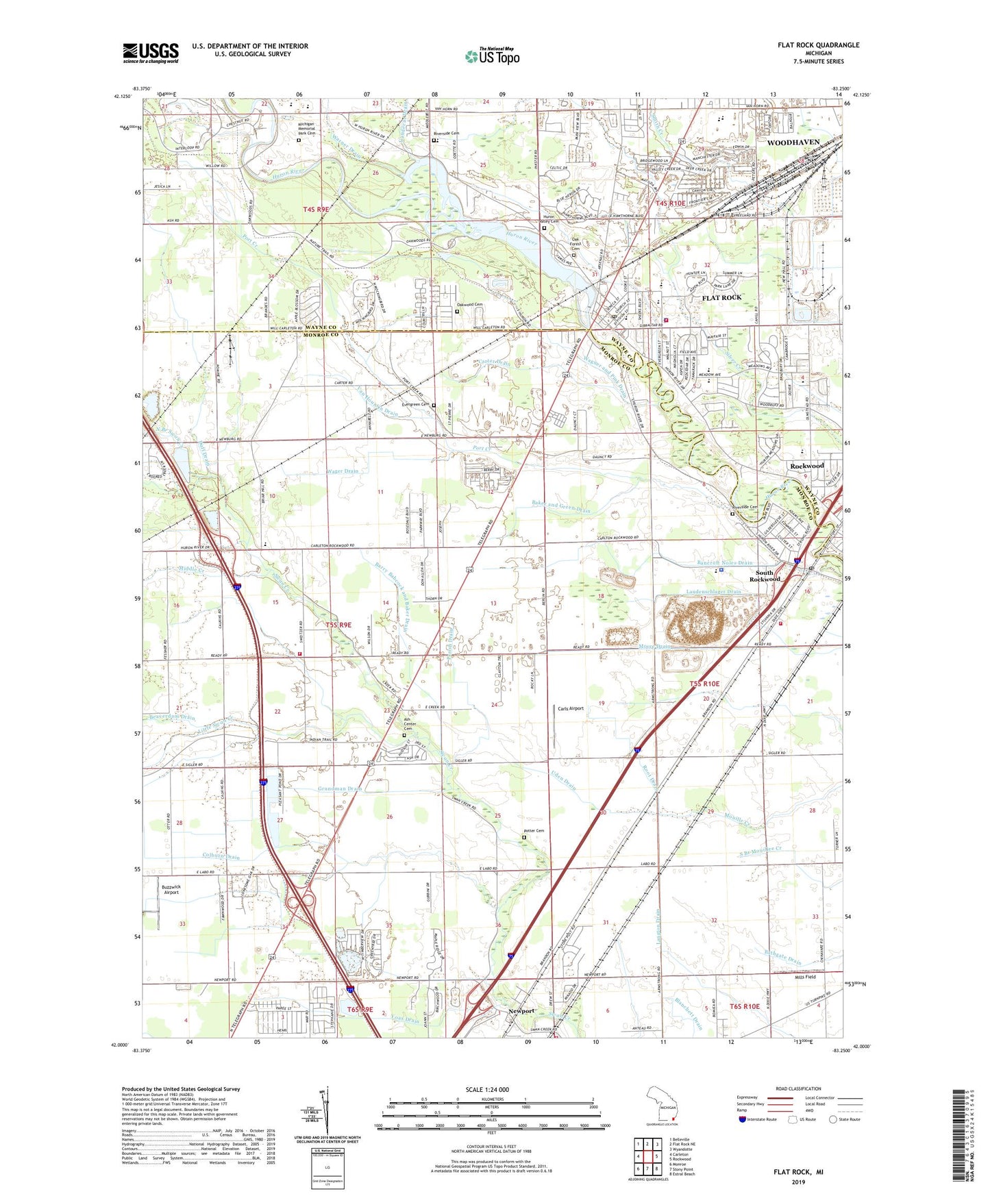
2023 topographic map quadrangle Flat Rock in the state of Michigan. Scale: 1:24000. Based on the newly updated USGS 7.5' US Topo map series, this map is in the following counties: Monroe, Wayne. The map contains contour data, water features, and other items you are used to seeing on USGS maps, but also has updated roads and other features. This is the next generation of topographic maps. Printed on high-quality waterproof paper with UV fade-resistant inks.
Quads adjacent to this one:
West: Carleton
Northwest: Belleville
North: Flat Rock NE
Northeast: Wyandotte
East: Rockwood
Southeast: Estral Beach
South: Stony Point
Southwest: Monroe
This map covers the same area as the classic USGS quad with code o42083a3.
Contains the following named places: Ash Center Cemetery, Ash Township Fire Department Station 2, Baker and Green Drain, Barry Babcock and Baker Drain, Beaverdam Drain, Berlin Township Fire Department Station 1, Berlin Township Fire Department Station 2, Buzzwick Airport, Carleton Rest Area, Carls Airport, Carter Drain, Chapman School, Charter Township of Berlin, City of Flat Rock, Colburn Drain, Cornelius G Munger General Store Historical Marker, Duff Drain, Ethel C Bobcean Elementary School, Evergreen School, Faith Church, Flat Rock, Flat Rock Community Building Pre-Kindergarten School, Flat Rock Courthouse, Flat Rock Fire Department, Flat Rock Library, Flat Rock Police Department, Flat Rock Post Office, Flat Rock Shopping Center Shopping Center, Flat Rock Speedway, Flat Rock Station, Flat Rock Village Mobile Home Park, Flat Rock Yard, Four Star Greenhouse Shopping Center, Fred W Ritter Elementary School, Grundman Drain, Huron Community Center, Huron Valley Cemetery, Little Swan Creek, Loren Eyler Elementary School, Maple Grove School, Michigan Memorial Park Cemetery, Middle Creek, Mills Field, Monroe Community Ambulance Ash Township, Moore Drain, New Boston Fire Hall Number 2, Newport, Newport Community Church, Newport Fireman's Park, Newport Post Office, Newport Station, Nike Park, North Branch Swan Creek, Oak Forest Cemetery, Oakwood Cemetery, Oakwoods Metropark, Parish Drain, Port Creek, Port Creek Cemetery, Port Creek School, Potter Cemetery, Riverside Cemetery, Rofter and McCormick Drain, Root Drain, Rose of Sharon Baptist Church, Rose of Sharon Church, Rupert Farm Cemetery, Saint Rochs Church, Simpson Junior High School, South Rockwood, South Rockwood Library, South Rockwood Methodist Church, South Rockwood Police Department, South Rockwood Post Office, South Rockwood Station, Sunnyside Kindergarten Center, The Ford Lamp Factory Complex Historical Marker, Township of Ash, Uden Drain, Van Hountin Drain, Vandecar Drain, Village of South Rockwood, Wager Drain, Wagner and Pink Drain, Warner Drain, Wesburn Golf Club, Willow Metro Park, WNZK-AM (Dearborn Heights), Woodhaven High School, Wyndridge Oaks Golf Course, Yoas Drain, ZIP Codes: 48134, 48179