MyTopo
Flat Rock NE Michigan US Topo Map
Couldn't load pickup availability
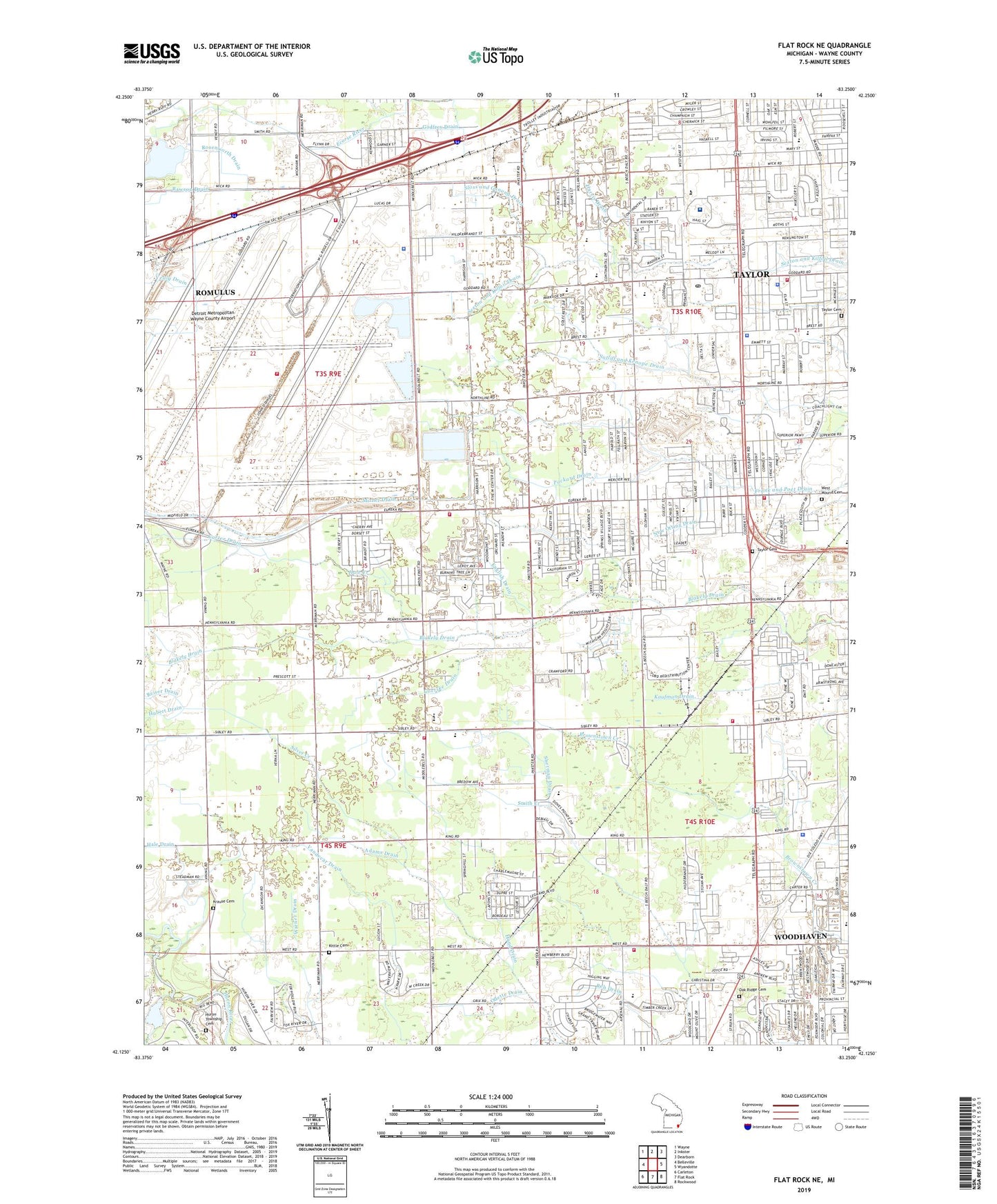
2023 topographic map quadrangle Flat Rock NE in the state of Michigan. Scale: 1:24000. Based on the newly updated USGS 7.5' US Topo map series, this map is in the following counties: Wayne. The map contains contour data, water features, and other items you are used to seeing on USGS maps, but also has updated roads and other features. This is the next generation of topographic maps. Printed on high-quality waterproof paper with UV fade-resistant inks.
Quads adjacent to this one:
West: Belleville
Northwest: Wayne
North: Inkster
Northeast: Dearborn
East: Wyandotte
Southeast: Rockwood
South: Flat Rock
Southwest: Carleton
This map covers the same area as the classic USGS quad with code o42083b3.
Contains the following named places: Adams Drain, Baptist Park School, Barry Memorial Church, Bates School, Batham Drain, Beaumont Hospital, Beaumont Mobile Medicine, Bernice McDowell Elementary School, Brake School, Brownstown Middle School, Brownstown Township Fire Department Station 1 Headquarters, Brownstown Township Fire Department Station 4, Brownstown Township Hall, Brownstown Township Police Department, Cadillac School, Cambridge Square Shopping Center, Capital Park, Carl T Renton Junior High School, Carter Drain, Charter Township of Huron, City of Romulus, City of Taylor, Detroit Metropolitan Wayne County Airport, Detroit Metropolitan Wayne County Airport Fire Department Station 100, Detroit Metropolitan Wayne County Airport Fire Department Station 200, Emmanuel Church, English Drain, Eureka Heights Elementary School, Eurekadale School, Evangel Church, F and M Shopping Center, Fairlane Church, Fellowship Church, Fisher School, Fletcher School, Frazier Park, Freeman Drain, Gander Mountain Shopping Center, Goetske Drain, Gordonier School, Gudith Elementary School, Hale Creek, Hale Creek Elementary School, Hale Drain, Hand Drain, Hand School, Harris Drain, Harrison School, Henry Ford Medical Center - Taylor, Heritage Four Park, Heritage One Park, Heritage Park, Holland School, Hope Church, Hubert Drain, Huron Township Cemetery, Huron Township Fire Department Station 3, Jacques Drain, John F Kennedy School, Kaufman Drain, Kirby Church, Kittle Cemetery, Krause Cemetery, Lakes of Taylor Golf Club, Medic One Ambulance Service, Merriman Elementary School, Michigan Automotive Academy, Michigan State Police District 2 Headquarters, Missionary Church, Mizner Drain, New Otting Drain, Oak Ridge Cemetery, Oakwood Academy, Odette Drain, Our Redeemer Church, Packard Drain, Papp Park, Poet Drain, Preston Post Office, Randall School, Rawson Drain, Regan Drain, Reh Drain, Reiser Drain, Romulus Army Air Field, Romulus Fire Department Station 1 Headquarters, Rosenworth Drain, Rotary Park, Saint Alfred School, Saint Johns School, Saint Paul Church, Sandhill Cemetery Historical Marker, Sherman Drain, Shook Drain, Sloss and Ganong Drain, Snow Drain, Southland Center Shopping Center, Summit Academy North, Taylor, Taylor Career and Technical Center, Taylor Cemetery, Taylor Center, Taylor Center Baptist Academy, Taylor Center High School, Taylor Center Post Office, Taylor Center School, Taylor City Hall, Taylor Fire Department Station 1, Taylor Fire Department Station 3, Taylor Junior High School, Taylor Methodist Episcopal Church Cemetery Historical Marker, Taylor Police Department, Taylor Post Office, Taylor Retail Center Shopping Center, Taylor Township Cemetery Historical Marker, Tel Sibley Plaza Shopping Center, Tele-Goddard Shopping Center, Texas Marsh Drain, Texas School, Thorn Park, Titan Alternative High School, Trillium Academy, Vealy Drain, Wayne County Airport Authority Police Department, WCHB-AM (Taylor), Wegienka Elementary School, West Mound Cemetery, West Road Church, Willow Metropark, Willow Metropark Golf Course, Zink Drain, ZIP Codes: 48180, 48242