MyTopo
Saint Johns North Michigan US Topo Map
Couldn't load pickup availability
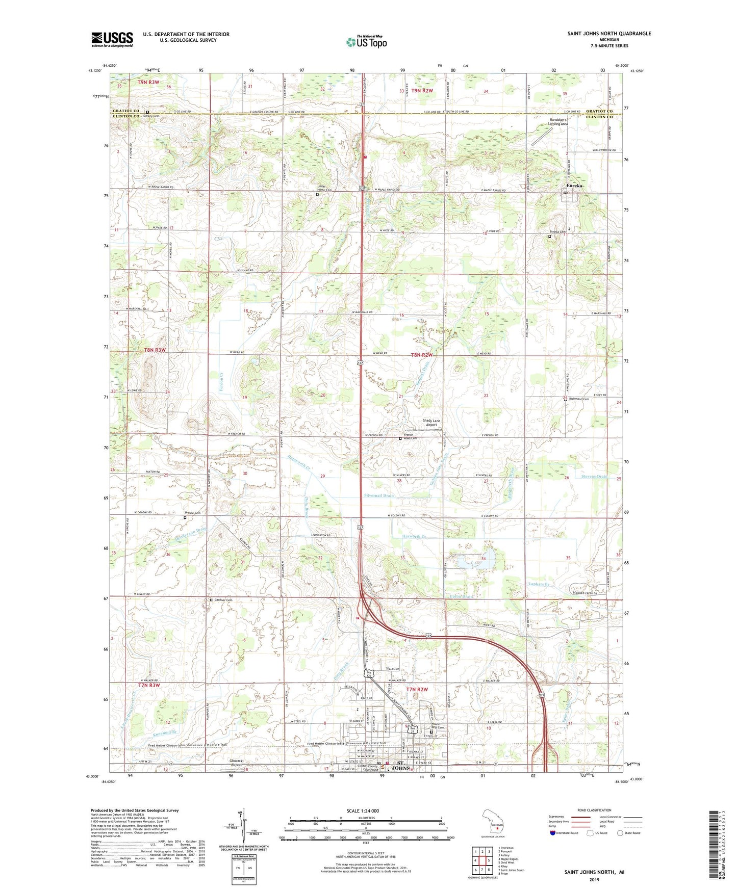
2023 topographic map quadrangle Saint Johns North in the state of Michigan. Scale: 1:24000. Based on the newly updated USGS 7.5' US Topo map series, this map is in the following counties: Clinton, Gratiot. The map contains contour data, water features, and other items you are used to seeing on USGS maps, but also has updated roads and other features. This is the next generation of topographic maps. Printed on high-quality waterproof paper with UV fade-resistant inks.
Quads adjacent to this one:
West: Maple Rapids
Northwest: Perrinton
North: Pompeii
Northeast: Ashley
East: Ovid West
Southeast: Price
South: Saint Johns South
Southwest: Riley
This map covers the same area as the classic USGS quad with code o43084a5.
Contains the following named places: B K Ranch, Bennett Drain, Big Clinton Lake, Briggs Public Library, Campbell Farms, Church of the Nazarene, City of Saint Johns, Clinton Area Fire and Rescue Station 1 Headquarters, Clinton Area Fire and Rescue Station 5, Clinton County Courthouse, Clinton Lakes County Park, Community Christian Church, Danley Cemetery, Demott Farms, Doty Brook, East Ward School, Emerald at Maple Creek Golf Course, Eureka, Eureka Cemetery, Eureka Census Designated Place, Eureka Christian Church, Eureka Christian School, Eureka Post Office, Eureka School, First Church of God, First Congregational Church, First Pentecostal Church of God, First United Methodist Church, Francis Motz County Park, French Road Cemetery, French School, Gardner Cemetery, Gardner School, Gateway North Elementary School, Gingrich Farms, Glowacki Airport, Golden Gate Drain, Goodrich Acres Strawberry Farm, Gove Farm, Greenbush Church, Greenbush Farms, Greenbush United Methodist Church Historical Marker, Greenwood School, Havens Farms, Hayworth Drain, Henderson Drain, Hold Your Horses Ranch, Jehovah's Witnesses, Kelley Drain, Kneeland Branch, Lamers Farms, Lapham Branch, Little Clinton Lake, Livingston Farms, Lowe Drain, Lyon's Mill Post Office, McPherson Farms, Mount Hope Saint Johns Family Church, Mount Rest Cemetery, Paine-Gillam-Scott House Historical Marker, Parker School, Prairie Cemetery, Randolph's Landing Area, Reorganized Church of Jesus Christ of Latter Day Saints, Richmond Cemetery, Richmond School, Sage School, Saint Johns, Saint John's Church Historical Marker, Saint John's Episcopal Church, Saint Johns Fire Department, Saint Johns Mobile Home Village, Saint Johns Post Office, Saint Johns Station, Saint Joseph Catholic Church, Saint Joseph School, Salem Church, Searles Lake, Shady Lane Airport, Sherwood School, Shulters and Stubbs Drain, Silvernail Drain, Summer Farms, Township of Greenbush, Twin Oaks Golf Course, Union Home Cemetery, Union Home Post Office, Upton Drain, Willowbrook Farm, ZIP Code: 48879