MyTopo
Tecumseh North Michigan US Topo Map
Couldn't load pickup availability
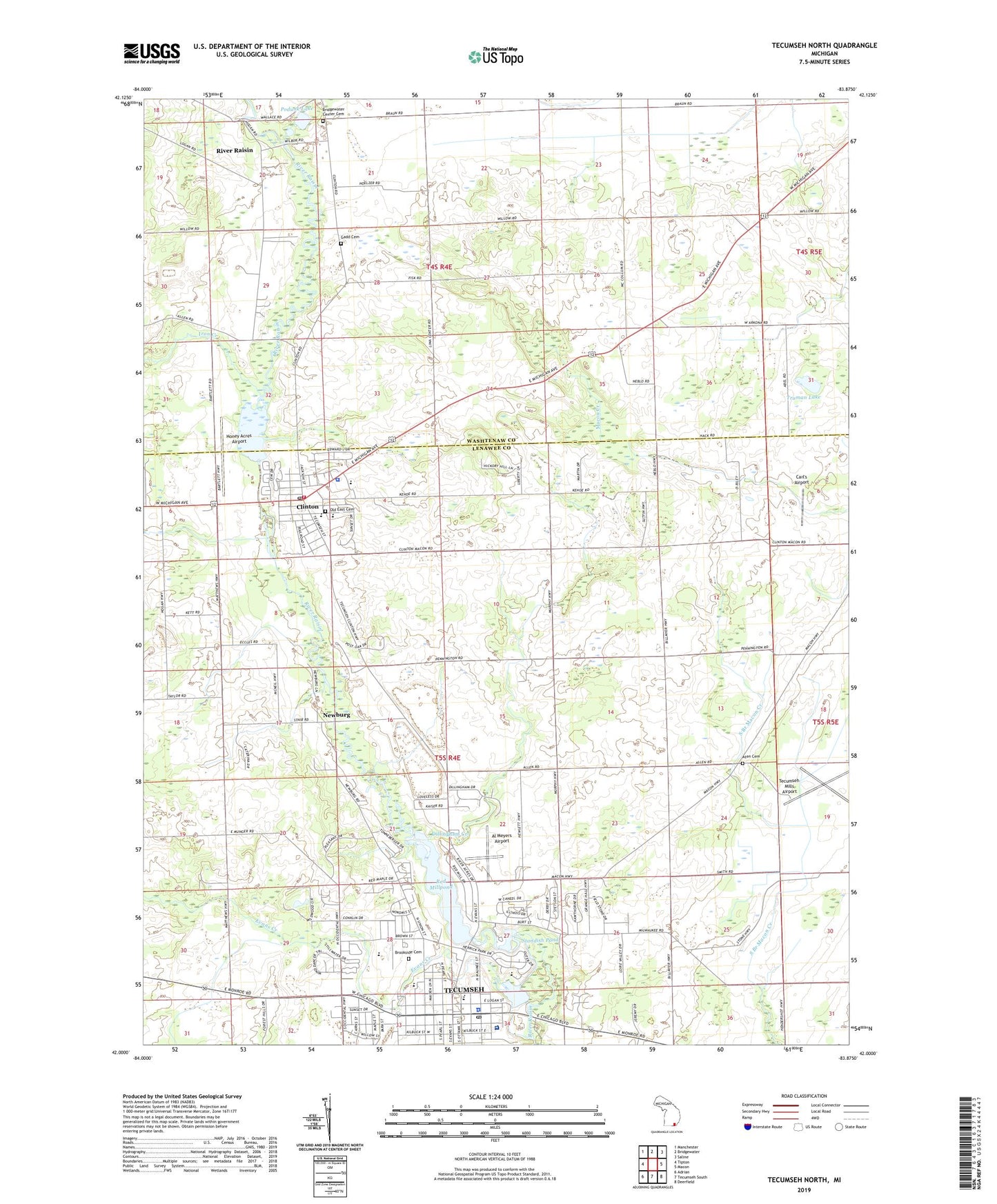
2023 topographic map quadrangle Tecumseh North in the state of Michigan. Scale: 1:24000. Based on the newly updated USGS 7.5' US Topo map series, this map is in the following counties: Lenawee, Washtenaw. The map contains contour data, water features, and other items you are used to seeing on USGS maps, but also has updated roads and other features. This is the next generation of topographic maps. Printed on high-quality waterproof paper with UV fade-resistant inks.
Quads adjacent to this one:
West: Tipton
Northwest: Manchester
North: Bridgewater
Northeast: Saline
East: Macon
Southeast: Deerfield
South: Tecumseh South
Southwest: Adrian
This map covers the same area as the classic USGS quad with code o42083a8.
Contains the following named places: Adams Park, Aden Mead Park, Al Meyers Airport, Al Meyers Airport Historical Marker, Allen's Trailer Court, Aten Cemetery, Beardsley Park, Bird Park, Bridgewater Center Cemetery, Bridgewater Town Hall Historical Marker, Bridgewater Township Hall, Brookside Cemetery, Carl's Airport, Church of Christ, Church of the Nazarene, City of Tecumseh, Clinton, Clinton Baptist Church, Clinton Elementary School, Clinton Fire Department, Clinton Foot and Ankle Clinic, Clinton Health Center, Clinton High School, Clinton Historical Marker, Clinton Library, Clinton Middle School, Clinton Police Department, Clinton Post Office, Clinton Station, Clinton Township Public Library, Clinton United Methodist Church, Clinton United Methodist Church Historical Marker, Clinton Woolen Mill Historical Marker, Dillingham Creek, Elliot Park, Evans Creek, Evans House Historical Marker, Evans Park, First Baptist Church, First United Presbyterian Church, Friends Church, Gadd Cemetery, Gloria Dei Lutheran Church, Grace Evangelical Lutheran Church, Herrick Medical Center, Herrick Park School, Honey Acres Airport, Hotrum Park, Indian Crossing Trails Park, Iron Creek, Jira Payne House Historical Marker, La Plaisance Bay Pike Historical Marker, Markham Airport, Mill Pond, Missionary Baptist Church, Newburg, Newburg Post Office, Old East Cemetery, Patterson Park, Patterson School, Podunk Lake, ProMedica Herrick Hospital, Red Millpond, River Raisin, River Raisin Post Office, Riverside Mortuary Chapel Historical Marker, Rustic Glen Golf Course, Saint Dominic Church, Saint Elizabeth Catholic Church, Saint John's Episcopal Church, Saint John's Episcopal Church Historical Marker, Saint Joseph Academy, Saint Peter's Episcopal Church, Satterthwaite Park, Site of the Clinton Inn Historical Marker, Smith-Kimball Family Historical Marker, Solid Rock Church of Lenawee, Standish Dam, Standish Dam Park, Standish Pond, Sunset Street Park, Tate Park, Tecumseh, Tecumseh Area Museum, Tecumseh Assembly of God Church, Tecumseh Church of God, Tecumseh City Hall, Tecumseh Country Club, Tecumseh District Library, Tecumseh Family Practice, Tecumseh High School, Tecumseh Middle School, Tecumseh Mills Airport, Tecumseh Police Department, Tecumseh Post Office, Tecumseh Products Airport, Tecumseh Station, Tecumseh United Methodist Church, Township of Bridgewater, Township of Clinton, Township of Tecumseh, Truman Lake, United Church of Christ, Village of Clinton, Wesley Fellowship Church, West Branch School, Wirt Rowland Historical Marker, ZIP Codes: 49236, 49286