MyTopo
Wayne Michigan US Topo Map
Couldn't load pickup availability
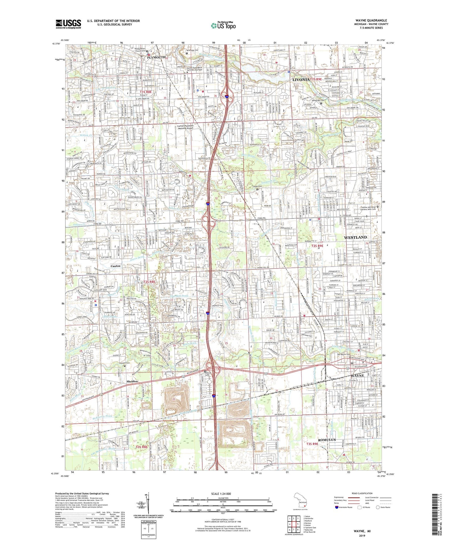
2023 topographic map quadrangle Wayne in the state of Michigan. Scale: 1:24000. Based on the newly updated USGS 7.5' US Topo map series, this map is in the following counties: Wayne. The map contains contour data, water features, and other items you are used to seeing on USGS maps, but also has updated roads and other features. This is the next generation of topographic maps. Printed on high-quality waterproof paper with UV fade-resistant inks.
Quads adjacent to this one:
West: Denton
Northwest: Salem
North: Northville
Northeast: Redford
East: Inkster
Southeast: Flat Rock NE
South: Belleville
Southwest: Ypsilanti East
This map covers the same area as the classic USGS quad with code o42083c4.
Contains the following named places: Agape Christian Academy, Allen School, Baker House Historical Marker, Barchester Park, Bell Drain, Bentley Elementary School, Berean Church, Beverly School, Bingell Drain, Bird School, Cadillac Memorial Gardens West Cemetery, Cady School, Calvary Church, Canton, Canton Census Designated Place, Canton Center School Historical Marker, Canton Corners Shopping Center, Canton Fire Department Station 1, Canton High School, Canton Medical Office Building, Canton Police Department, Canton Post Office, Canton Township Fire Department Station 2, Canton Township Hall, Canton-Plymouth-Mettetal Airport, Central City Park, Central City Plaza Shopping Center, Centre Village of Canton Shopping Center, Chamberlain Playground, Charles G Curtiss House Historical Marker, Charter Township of Canton, Charter Township of Plymouth, Chatham Center Shopping Center, Cherry Hill Court Shopping Center, Chief Tonquish Burial Site Historical Marker, Chubb Cemetery, Churchill High School, City of Plymouth, City of Wayne, City of Westland, Cleveland School, Country Homes Park, Coventry Commons Shopping Center, Crescent Academy International, Curtis Woods Park, Deer Drain, Downer Cemetery, Edison School, Edmund Creek, Eriksson Elementary School, Executive Heliport, Farmer Jack Commercial Center Shopping Center, Fellows Creek, Fellows Creek Golf Course, Fiegel School, First Congregational Church Historical Marker, Flodin Park, Freedom Park, Gallimore Elementary School, Gallimore School, Gardner White Furniture Shopping Center, Garfield School, Glenn High School, Green Drain, Griffin Park East, Hannan Drain, Harrison Drain, Harvard Square Shopping Center, Henry Ford Medical Center - Canton, Henry Ford Medical Center - Westland, Heritage Park, Hoben Elementary School, Holliday Park, Holy Cross Church, Hoover School, Hough Park, Hough School, Hulsing Elementary School, Hunt Playground, Hunter Drain, Hustin Drain, Isbister Elementary School, Jaycee Park, Johnson School, Johnson's Tavern Historical Marker, Junior High School East, Kaselemis Center, Kellogg Park, Kings Way Park, Kirk of Our Savior, Leng Drain, Lions Park, Livonia Career Technical Center, Livonia Fire and Rescue Station 6, Livonia Library, Lowell Junior High School, Madison School, Marshall Junior High School, McClaughrey Drain, McKinstry Drain, Metro Charter Academy, Miller Elementary School, Monroe School, Morgan Drain, Mott Drain, Mount Olive Church, Nankin Post Office, Nankin Township School District Number Three Historical Marker, New Towne Plaza Shopping Center, Newburg Methodist Church Historical Marker, Newburgh Cemetery, Newburgh Cemetery Historical Marker, Newburgh Lake, North Branch Fellows Creek, Norwayne, Oak Vale Park, Oakwood Healthcare Center - Canton, Oakwood Healthcare Center - North Westland, Old Wayne Cemetery, Old Wayne Village Hall Historical Marker, Our Lady of Good Counsel School, Patchen School, Patchin Elementary School, Pheasant Run Golf Club, Pioneer Middle School, Plymouth, Plymouth Christian Academy, Plymouth City Police Department, Plymouth Health Center, Plymouth High School, Plymouth Historical Marker, Plymouth Junior High School West, Plymouth Riverside Park, Plymouth Square Shopping Center, Plymouth Township Census Designated Place, Plymouth Township Fire Department Station 1 Headquarters, Plymouth Township Police Department, Plymouth-Canton Health Center, Prayer Church, Pursell Post Office, Radcliff Junior High School, Riverside Cemetery, Romulus Fire and Rescue Department Station 3, Roosevelt School, Roosevelt-McGrath Elementary School, Saint Johns Church, Saint John's Evangelical Lutheran School, Saint Johns School, Saint Joseph Mercy Health Building - Canton, Saint Joseph Mercy Health Building - Plymouth, Saint Michael Christian School, Saint Michael Church, Saint Peter Lutheran Day School, Saint Theodore Church, Salem High School, Schweitzer School, Sears Plaza Shopping Center, Sheldon, Sheldon Cemetery, Sheldon Center Shopping Center, Sheldon School, Sheldon's Corners Historical Marker, Shuart Drain, Sines Drain, Smith School, Soroptimist Park, South Branch McKinstry Drain, South Branch Tonquish Creek, Stark School, Stevenson Junior High School, Stottlemeyer School, Stottlemyer Early Childhood Center, Sutherland House Historical Marker, Tattan Park, Tonquish Post Office, Travis Drain, Truesdell Drain, Truesdell School, Victory Park, Wagon Wheel Park, Walker School, Walker-Winter Elementary School, War Memorial Park, Washington School, Wayne, Wayne Commons Shopping Center, Wayne County Sheriff's Office Mounted / Parks Division, Wayne Courthouse, Wayne District Courthouse, Wayne Fire Department, Wayne Greyhound Station, Wayne Historical Museum, Wayne Memorial High School, Wayne Plaza Shopping Center, Wayne Post Office, Wayne Station, West High School, Westland, Westland Christian Academy, Westland City Hall, Westland Crossings Shopping Center, Westland Fire Department Station 1 Headquarters, Westland Fire Department Station 4, Westland Fire Prevention Division, Westland Library, Westland Police Department, Westland Post Office, Westland Rest Area, Wilbur Drain, Wildwood School, Wiles Drain, William Ford Career and Technical Center, Willow Creek, Wilson School, WNZK-AM (Westland), Woodlands Golf Course, WSDP-FM (Plymouth), Yost Drain, ZIP Codes: 48150, 48184, 48185, 48187, 48188