MyTopo
Belleville Michigan US Topo Map
Couldn't load pickup availability
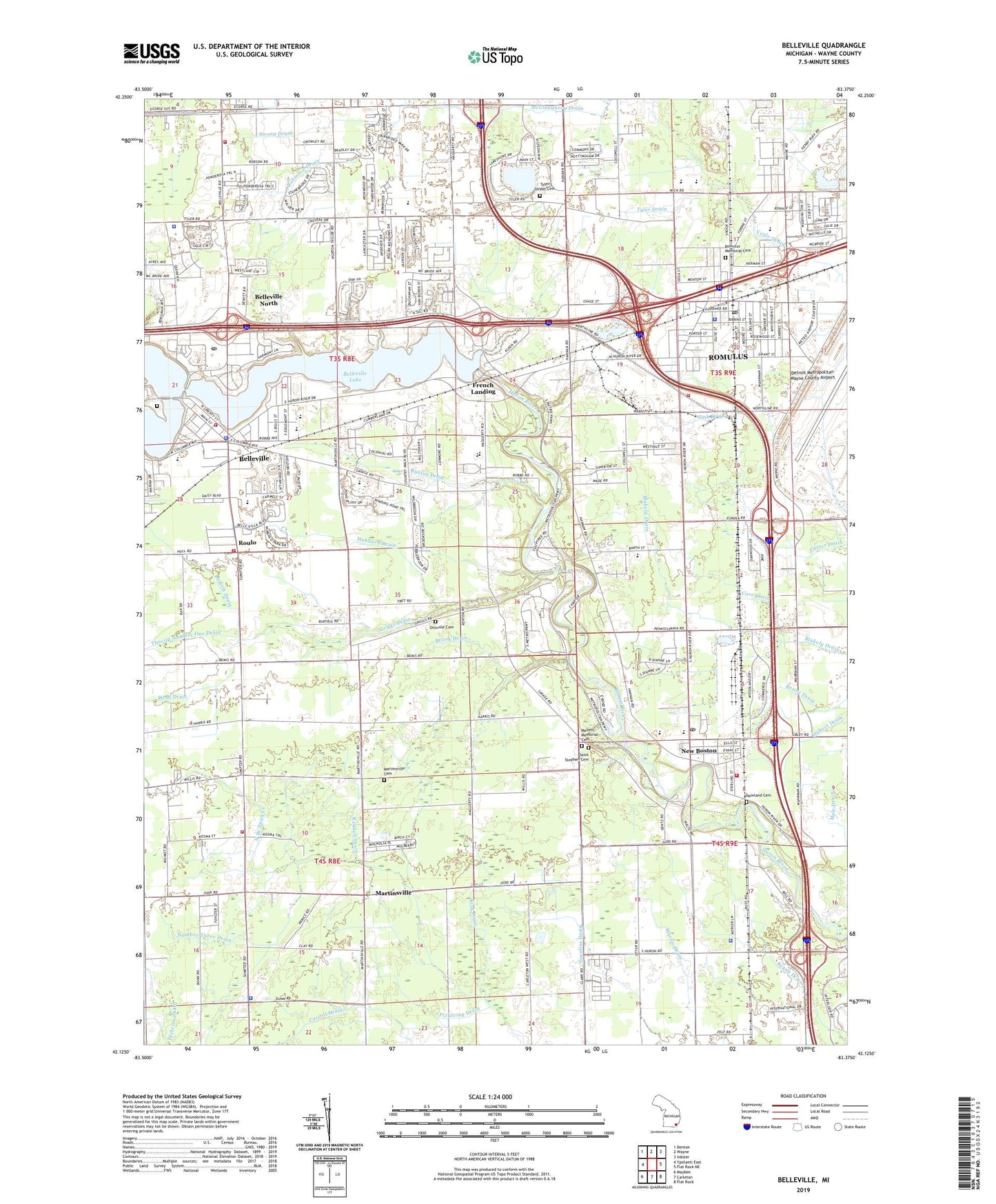
2023 topographic map quadrangle Belleville in the state of Michigan. Scale: 1:24000. Based on the newly updated USGS 7.5' US Topo map series, this map is in the following counties: Wayne. The map contains contour data, water features, and other items you are used to seeing on USGS maps, but also has updated roads and other features. This is the next generation of topographic maps. Printed on high-quality waterproof paper with UV fade-resistant inks.
Quads adjacent to this one:
West: Ypsilanti East
Northwest: Denton
North: Wayne
Northeast: Inkster
East: Flat Rock NE
Southeast: Flat Rock
South: Carleton
Southwest: Maybee
This map covers the same area as the classic USGS quad with code o42083b4.
Contains the following named places: ATI Heliport, Barth Elementary School, Belleville, Belleville Area Chamber of Commerce, Belleville Area Museum, Belleville Courthouse, Belleville Fire Department, Belleville Lake, Belleville North, Belleville Police Department, Belleville Post Office, Belleville Square Shopping Center, Belleville Station, Bethel Church, Bethlehem Church, Bridger Drain, Brook Drain, Bunton Drain, Carr Drain, Carroll Drain, Charter Township of Van Buren, City of Belleville, Community Middle and Community High School, Corey School, Edgemont School, Elmer Johnson Park, Elwell School, Fred C Fischer Library, French Landing, French Landing Dam and Powerhouse Historical Marker, French Landing Station, Frenchlanding Post Office, Griggs Drain, Haggerty Road School, Head Drain, Hillside Cemetery, Hope Chapel, Hosmer Drain, Hubbard Drain, Huron Town Hall, Huron Township Fire Department Station 1 Headquarters, Huron Township Fire Station, Huron Township Police Department, Huron Valley Church, Kennedy Park, Kenneth E Berlinn Memorial Park, King Drain, Lower Huron Metropolitan Park, Lower Huron Par Three Golf Course, Mallett Memorial Cemetery, Martinsville, Martinsville Cemetery, Martinsville Post Office, McBride Drain, Merrill-Morris House Historical Marker, Metro Baptist School, Mount Harmon Church, Mount Pleasant School, New Boston, New Boston Post Office, New Boston Station, Nowland Cemetery, Number Three Drain, Oakwood Healthcare Center - Belleville, Old Van Buren Township Hall Historical Marker, Otisville Cemetery, Pickering Drain, Pleasant Valley Church, Post Drain, Quirk Road School, Randell Drain, Robinson Drain, Romulus, Romulus Adult Education Alternative School, Romulus City Hall, Romulus Civic Center, Romulus Fire and Rescue Department Station 1, Romulus Fire Department, Romulus Historical Museum, Romulus Library, Romulus Memorial Cemetery, Romulus North Junior High School, Romulus Police Department, Romulus Post Office, Romulus Senior High School, Roulo, Saint Anthony Academy, Saint Stephen Catholic School, Saint Stephen Cemetery, Saint Stephen School, Sandy's Marina, Savage Road Elementary School, Shady Hollow Golf Course, Strong Drain, Sumpter School, Sumpter Township Fire Department Station 1 Headquarters, Sumpter Township Hall, Sumpter Township Police Department, Thirty-Forth District Court, Throop Number One Drain, Throop Number Two Drain, Township of Sumpter, Tyler Drain, Tyler Road Elementary School, Tyler Street Cemetery, Van Buren Alternative Education School, Van Buren Township Fire Department Station 1, Van Buren Township Fire Department Station 2, Van Buren Township Hall, Van Buren Township Police Department, Wayne County Community College, Wayne County Fairground, Weightman Drain, Wick Elementary School, William D Miller Elementary School, Willow Run Air Force Station, ZIP Codes: 48111, 48174