MyTopo
Ypsilanti East Michigan US Topo Map
Couldn't load pickup availability
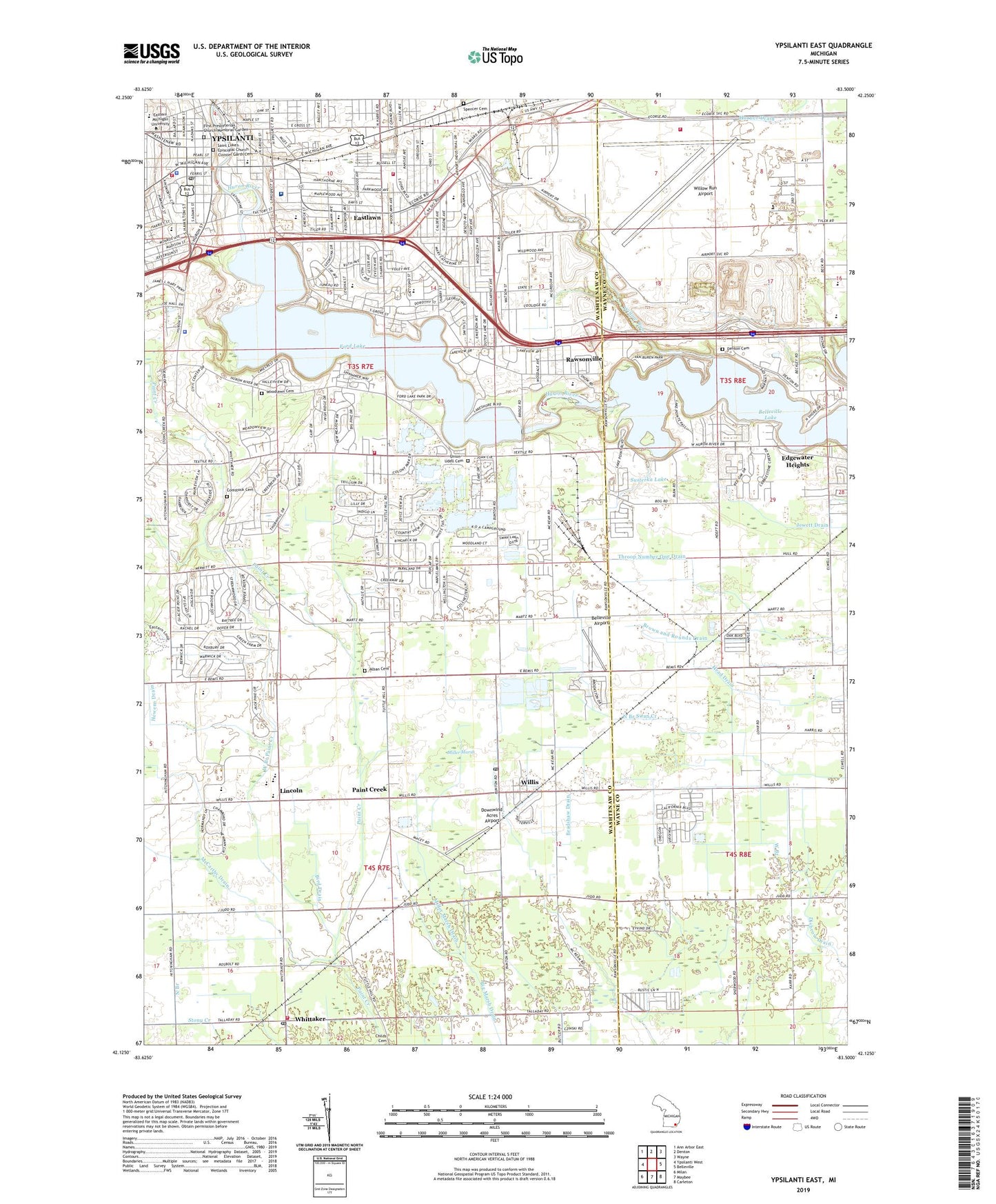
2023 topographic map quadrangle Ypsilanti East in the state of Michigan. Scale: 1:24000. Based on the newly updated USGS 7.5' US Topo map series, this map is in the following counties: Washtenaw, Wayne. The map contains contour data, water features, and other items you are used to seeing on USGS maps, but also has updated roads and other features. This is the next generation of topographic maps. Printed on high-quality waterproof paper with UV fade-resistant inks.
Quads adjacent to this one:
West: Ypsilanti West
Northwest: Ann Arbor East
North: Denton
Northeast: Wayne
East: Belleville
Southeast: Carleton
South: Maybee
Southwest: Milan
This map covers the same area as the classic USGS quad with code o42083b5.
Contains the following named places: Adams School, Alban Cemetery, Alexander Music Building, Augusta Township Fire Department Station 1, Beautiful Gate Church, Belleville Airport, Belleville Pointe Park, Belleville Rest Area, Bible Church, Bird Drain, Boone Hall, Brick Elementary School, Brown and Rounds Drain, Burning Bush Church of God, Calvary Baptist Church, Calvary Christian Academy, Campbell Chapel African Methodist Episcopal Church, Carrie Mattingly Tot Lot, Central School, Charter Township of Augusta, Charter Township of Ypsilanti, Childs Elementary School, Christ Temple Apostolic Church, Christian Life Center Church, Church of Christ, Church of God of Prophecy, Church of Jesus Christ of Latter Day Saints, City of Ypsilanti, Coatings Research Institute, Community Christian Assembly of God Church, Community Church of God, Community Freewill Baptist Church, Comstock Cemetery, Detroit Greenfield RV Park, Detroit Metropolitan Wayne County Airport Fire Department Station 700, Downwind Acres Airport, Eagle Crest Golf Club, East Branch, East Junior High School, Eastern Michigan College Historical Marker, Eastern Michigan University, Eastlawn, Edgewater Heights, Elijah McCoy Historical Marker, Elwell Elementary School, Emmanuel Lutheran Church, Erickson School, Everett L. Marshall Building, Faith Assembly Church of Ypsilanti, First Congregational United Church of Christ, First Methodist Episcopal Church Historical Marker, First Presbyterian Church Historical Marker, First Presbyterian Church Memorial Garden, First Presbyterian Church of Ypsilanti, First United Methodist Church, Ford Boulevard Mobile Home Park, Ford Dam, Ford Hall, Ford Heritage Park, Ford Lake, Ford Lake Park, Forest Avenue Baptist Church, Forest Health Medical Center, Friends Church, Frog Island Park, Gault Village Shopping Center, George School, Goddard Residence Hall, Graceway Baptist Church, Greater Love Church of God in Christ, Greater Ypsilanti Community Church, Harbor Club Golf Course, Harris Park, Hewens Drain, Holy Trinity Chapel, Hope Medical Clinic, Huron Christian Church, Huron River Park, Jewett Drain, Jones Residence Hall, Kaiser School, Kettering Elementary School, King Hall, Ladies Literary Club Historical Marker, Lake in the Woods Country Club, Lakeside Park, Lakeview Mobile Home Park, Lakeview Park, Lincoln, Lincoln Community Methodist Church, Lincoln High School, Lincoln Middle School, Loonfeather Point Park, McCarthy Drain, McGraw Drain, Messias Temple Church, Metropolitan Memorial Baptist Church, Michigan Central Freighthouse Historical Marker, Michigan's Interurbans Historical Marker, Miller Marsh, Miller Marsh Drain, Model Elementary School, Mount Olive Church of God, Nancy Park, Neighborhood Health Clinic - Ypsilanti, New Beginnings Academy, New Covenant Missionary Baptist Church, New Creed Missionary Baptist Church, New Jerusalem Baptist Church, New Life Bible Baptist Church, North Bay Park, North Branch, North Branch Big Marsh Drain, North Hydro Park, North Middle School, Oakwood Hospital Beyer Center - Ypsilanti, Old Rawsonville Village Historical Marker, Open Door Church of God in Christ, Paint Creek, Parkridge Park, Pease Auditorium, Perry Child Development Center, Pierce Hall, Pine Creek Golf Course, Pine Park, Porter College of Education, Pray Harrold Building, President's Residence, Prospect Park, Prospect Park Historical Marker, Quirk Dramatic Arts Building, Rawsonville, Rawsonville Elementary School, Rawsonville Post Office, Redner Elementary School, Riverside Park, Roosevelt Hall, Saint John the Baptist Catholic Church, Saint John's Baptist Church, Saint Joseph Church, Saint Joseph Mercy-Oscar W Haab Health Building, Saint Luke's Cloister Garth Cemetery, Saint Lukes Episcopal Church, Saint Mark Lutheran Church, Saint Matthew's United Methodist Church, Second Baptist Church, Sherwood Park, Soop Cemetery, Spencer Cemetery, Starkweather Hall, Still Hall, Sugarbrook Park, Susterka Lake, Thurston School, Trinity Free Will Church, Union - Udell Cemetery, University of Michigan Institute of Science, Van Buren Township Park, Waterworks Park, Welch Hall, WEMU-FM (Ypsilanti), West Branch, West Branch Paint Creek, West Willow Church of God, West Willow Park, West Willow School, Whittake Station, Whittaker, Whittaker Free Will Baptist Church, Whittaker Post Office, Willis, Willis Baptist Church, Willis Post Office, Willis Station, Willow Run, Willow Run Airport, Willow Run Historical Marker, Woodlawn Cemetery, Ypsilanti, Ypsilanti Automobile Heritage Collection, Ypsilanti Baptist Temple, Ypsilanti City Hall, Ypsilanti City Library, Ypsilanti Commons Shopping Center, Ypsilanti DDC Post Office, Ypsilanti District Library, Ypsilanti Fire Department, Ypsilanti Firehouse Museum, Ypsilanti Health Center, Ypsilanti Historical Marker, Ypsilanti Historical Museum, Ypsilanti Missionary Church, Ypsilanti Mobile Home Village, Ypsilanti Police Department, Ypsilanti Post Office, Ypsilanti Seventh-Day Adventist Church, Ypsilanti Township Fire Department Station 1 Headquarters, Ypsilanti Township Fire Department Station 4, Ypsilanti Water Tower Historical Marker, ZIP Code: 48190