MyTopo
Gull Lake Minnesota US Topo Map
Couldn't load pickup availability
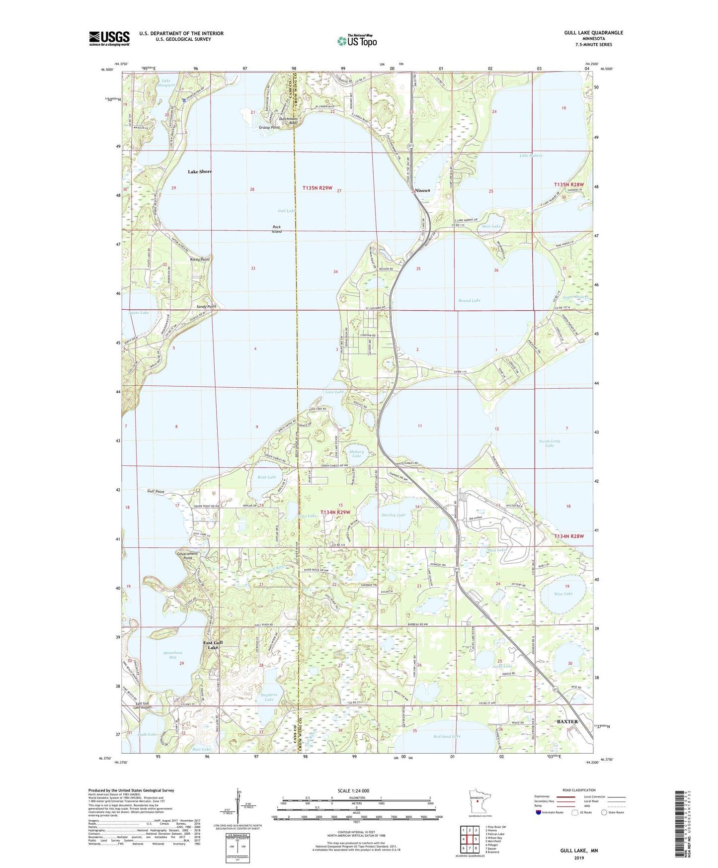
2023 topographic map quadrangle Gull Lake in the state of Minnesota. Scale: 1:24000. Based on the newly updated USGS 7.5' US Topo map series, this map is in the following counties: Crow Wing, Cass. The map contains contour data, water features, and other items you are used to seeing on USGS maps, but also has updated roads and other features. This is the next generation of topographic maps. Printed on high-quality waterproof paper with UV fade-resistant inks.
Quads adjacent to this one:
West: Wilson Bay
Northwest: Pine River SW
North: Nisswa
Northeast: Pelican Lake
East: Merrifield
Southeast: Brainerd
South: Baxter
Southwest: Pillager
This map covers the same area as the classic USGS quad with code o46094d3.
Contains the following named places: Agape Christian Church, Agate Lake, B I R Airport, Bass Lake, Birch Bay Golf Club, Brainerd Region Geological Marker, Camp Lake Hubert, Camp Lincoln, Carlson Lake, Church of the Nazarene, City of East Gull Lake, Dade Lake, Donnybrooke Speedway, Dutchmans Bluff, East Gull Lake, East Gull Lake Airport, East Gull Lake City Hall, Eastman Seaplane Base, Echo Lake, Government Point, Grassy Point, Gull and Love Lake Campground, Gull Lake, Gull Lake Dam, Gull Lake Reservoir, Gull Point, Hartley Lake, Hole-in-the-Day Lake, Home Brook, Jacks Lake, Kerch Community Chapel, Lake Hubert, Lake Margaret, Lake Shore, Lake Shore Police Department, Legacy Courses at Cragun's - Bobby's 18, Legacy Courses at Cragun's - Dutch 18, Legacy Courses at Cragun's Reversible Par Three, Little Lake Hubert, Living Savior Lutheran Church, Love Lake, Madden's the Classic Golf Course, Moburg Lake, Mud Lake, North Long Lake Rest Area, Pauls Seaplane Base, Rock Island, Rocky Point, Round Lake, Ruth Lake, Sandy Point, Steamboat Bay, Stephens Lake, Sugar Bush Creek, The Garden Course at Grand View Lodge, Wise Lake, ZIP Code: 56468