MyTopo
Florence Mississippi US Topo Map
Couldn't load pickup availability
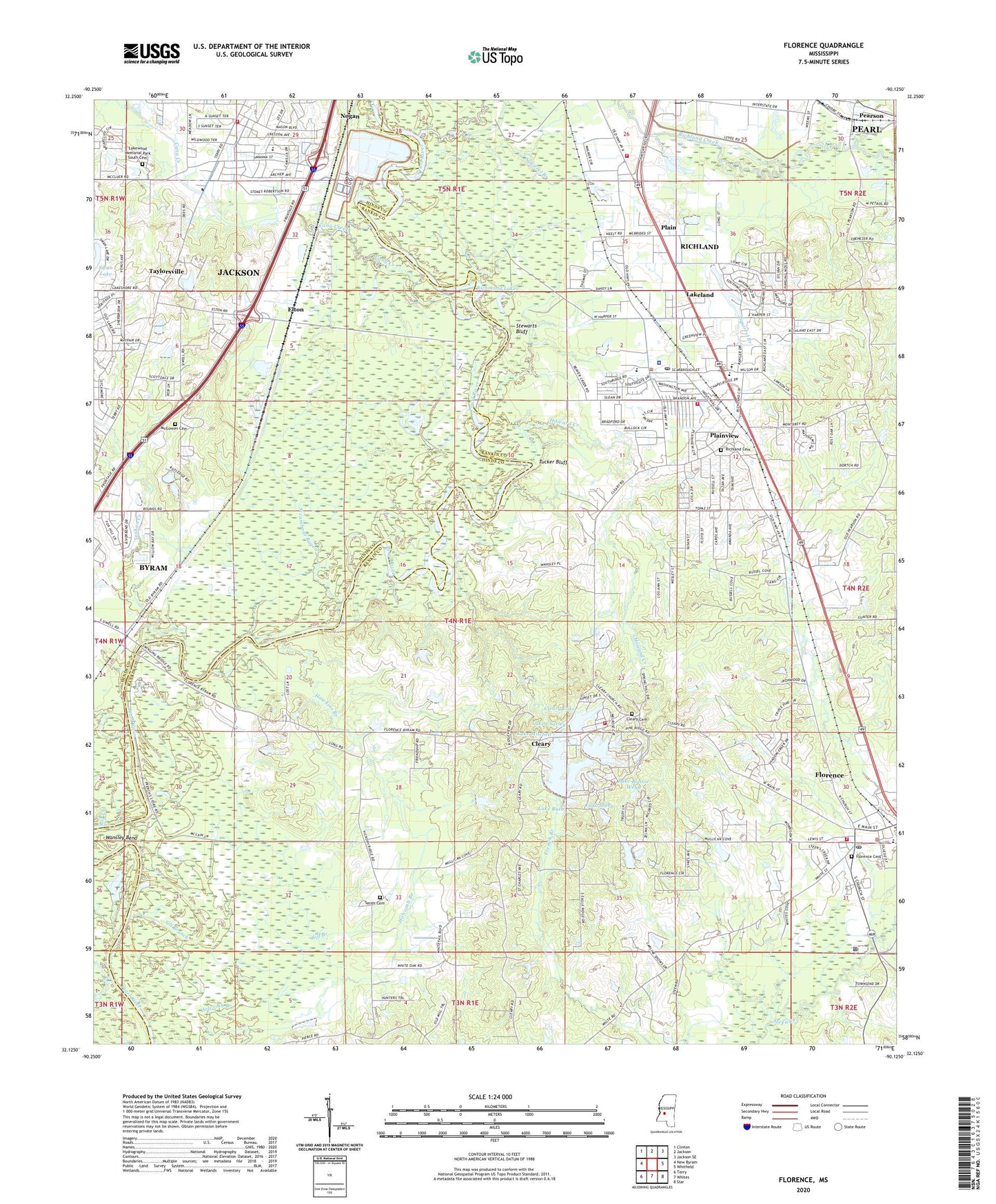
2024 topographic map quadrangle Florence in the state of Mississippi. Scale: 1:24000. Based on the newly updated USGS 7.5' US Topo map series, this map is in the following counties: Rankin, Hinds. The map contains contour data, water features, and other items you are used to seeing on USGS maps, but also has updated roads and other features. This is the next generation of topographic maps. Printed on high-quality waterproof paper with UV fade-resistant inks.
Quads adjacent to this one:
West: New Byram
Northwest: Clinton
North: Jackson
Northeast: Jackson SE
East: Whitfield
Southeast: Star
South: Whites
Southwest: Terry
This map covers the same area as the classic USGS quad with code o32090b2.
Contains the following named places: Amazing Grace Pentecostal Holiness Church, Big Creek, Blaine Pond Dam, Brookleigh Baptist Church, Byram, Byram United Methodist Church, Caney Creek Church of Christ Holiness, Cany Creek, Cedar Point, Chapel Hill School, Choctaw Village, Church of God, City of Richland, Cleary, Cleary Baptist Church, Cleary Cemetery, Cleary Census Designated Place, Cleary Heights, Cleary Lake, Cleary Lake Dam, Cleary Volunteer Fire Department, Confederate Heights Country Club, Confederate Heights Golf Club Dam, Confederate Heights Golf Club Number 2 Dam, Cooks Ferry, Cortney Lake Dam, Daniel Memorial Baptist Church, Easthaven Baptist Church, Ebenezer Church, Elton, Elton Place, Emmanuel Church of the Nazarene, First Baptist Church, Florence, Florence Cemetery, Florence Church of Christ, Florence Elementary School, Florence Fire Department Station 1 Headquarters, Florence Police Department, Florence Post Office, Florence Public Library, Frenchs Store, Grace Church of Christ, Griffith Memorial Baptist Church, Harbor House Chemical Dependency Services, Hawkins Branch, Hickory Ridge Church, Hickory Ridge School, Hoover Lake Dam, Hoover Lakes, Howard Creek, Jackson Fire Department District 2 Station 11, Jackson Sewage Lagoon Dam, Jesus Name Tabernacle, Lake Bonnie Webb, Lake Charley, Lake Mary, Lake Mitchell, Lake Ruth, Lakeland, Lakewood Memorial Park South Cemetery, Lee Elementary School, Lotts Mobile Home Park, Marvin United Methodist Church, Mayfair, McGowen Cemetery, McRainey Lake Dam, Mount Sinai Baptist Church, New Canney Creek Missionary Baptist Church, Nogan, Old Union School, Parham Bridge Park, Pearl Church of God, Pearson Baptist Church, Plain, Plain Landmark Missionary Baptist Church, Plainview, Red Hill, Rees Lake Dam, Reno Sportsman Lake, Richland, Richland Baptist Church, Richland Cemetery, Richland Church, Richland City Hall, Richland Creek, Richland Elementary School, Richland Estates, Richland Fire Department Station 1, Richland Fire Department Station 2, Richland High School, Richland Methodist Church, Richland Police Department, Richland Post Office, Richland Public Library, Richland United Pentecostal Church, Richmond, Richmond Lake, Riverwood Shopping Center, Sill Branch, Smith Cemetery, Smith Lake Dam, Southwood Estates, Spring Hill Church, Squirrel Branch, Steamboat Bayou, Stewarts Bluff, Supervisor District 1, Taylorsville, Trahon Creek, Tucker Bluff, Warren Place, WKKE-AM (Pearl), WWCJ-FM (Jackson), ZIP Code: 39218