MyTopo
Industrial Mississippi US Topo Map
Couldn't load pickup availability
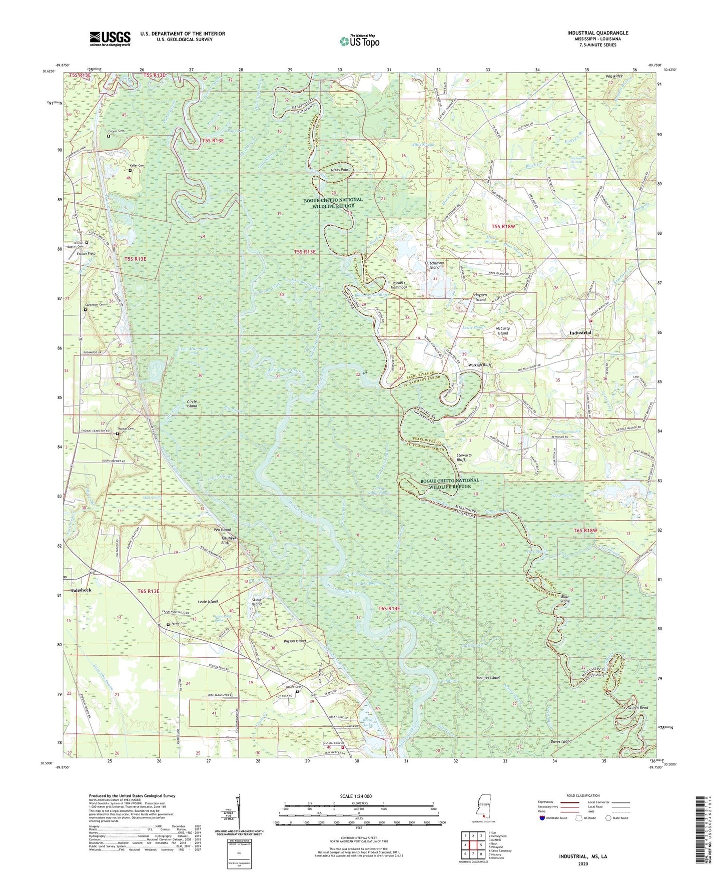
2024 topographic map quadrangle Industrial in the states of Louisiana, Mississippi. Scale: 1:24000. Based on the newly updated USGS 7.5' US Topo map series, this map is in the following counties: Pearl River, St. Tammany. The map contains contour data, water features, and other items you are used to seeing on USGS maps, but also has updated roads and other features. This is the next generation of topographic maps. Printed on high-quality waterproof paper with UV fade-resistant inks.
Quads adjacent to this one:
West: Bush
Northwest: Sun
North: Henleyfield
Northeast: McNeill
East: Picayune
Southeast: Nicholson
South: Hickory
Southwest: Saint Tammany
This map covers the same area as the classic USGS quad with code o30089e7.
Contains the following named places: Anders Bayou, Becky Lake, Big Bayou, Big Creek, Black Creek, Black Creek Cutoff, Black Lake, Boar Stone, Bogue Chitto, Bogue Chitto National Wildlife Refuge, Bradley Slough, Brier Patch Bayou, Brushy Branch, Byrd Bayou, Carpenter Cemetery, Casey Bayou, Catfish Lake, Circle Island, Clements Bayou, Copper Cemetery, Cow Bayou, Cow Hammock Lake, Cow Pen Bend, Crawford Bayou, Cryer Slough, Daves Island, Dobson Bayou, East Bogue Chitto, Farr Island, Fokker Field, Gum Landing, Gum Pond, Hebron Baptist Cemetery, Hebron Church, Hells Gate Bayou, Hickory Creek, Hogpen Branch, Hogpen Island, Holmes Island, Hutchinson Island, Industrial, Industrial Elementary School, Jarrell Creek, Jenkins Ridge Bayou, Joiner Lake, Keller Bayou, Keller Cemetery, Leslie Slough, Leslies Landing, Little Brushy Branch, Little Cannon Lake, Little River, Lock Number Two, Lotts Creek, Louie Island, Louie Reed Brake, Mars Slough, McCarty Island, McGee Cemetery, Middle Bogue Chitto, Moody Branch, Moses Branch, Mud Swamp, Nances Lake, Nances Reach, Nicks Point, Old Mud Swamp, Old Tar Landing, Page Lake, Parker Bayou, Parker Branch, Parker Cemetery, Parkers Hammock, Pea Ridge, Pearl River Canal Pool Number Two, Pearl River County Game Refuge, Pechochen Swamp, Pen Island, Pine Grove Church, Pine Grove Volunteer Fire Department Station 1 Headquarters, Purns Bayou, Rice Patch Lake, Saint Tammany Parish Fire District 7 Station 1, Saint Tammany Parish Sheriff's Office, Soloman Creek, Stewarts Bluff, Stock Island, Talisheek Bluff, Talisheek Creek, Talisheek Post Office, Thomas Cemetery, Turkey Pond, Twin Bayou, Walkiah, Walkiah Bluff, Walkiah Bluff Water Park, West Bogue Chitto, West Ponds, Wheat Swamp, White Oak Ridge Lake, Willis Slough, Wilson Island, Wilson Slough