MyTopo
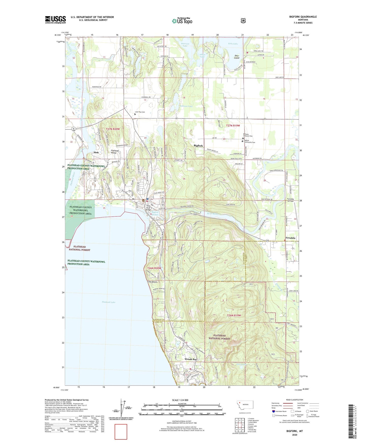
Bigfork Montana US Topo Map
Couldn't load pickup availability
Also explore the Bigfork Forest Service Topo of this same quad for updated USFS data
2024 topographic map quadrangle Bigfork in the state of Montana. Scale: 1:24000. Based on the newly updated USGS 7.5' US Topo map series, this map is in the following counties: Flathead, Lake. The map contains contour data, water features, and other items you are used to seeing on USGS maps, but also has updated roads and other features. This is the next generation of topographic maps. Printed on high-quality waterproof paper with UV fade-resistant inks.
Quads adjacent to this one:
West: Somers
Northwest: Creston
North: Hash Mountain
Northeast: Jewel Basin
East: Crater Lake
Southeast: Yew Creek
South: Woods Bay
Southwest: Rollins
This map covers the same area as the classic USGS quad with code o48114a1.
Contains the following named places: 26N19W03BCCA01 Well, 26N19W07BB__01 Well, 26N20W12AA__01 Well, 26N20W12DD__01 Well, 26N20W12DD__02 Well, 27N19W09BCDA01 Well, 27N19W16AA__01 Well, 27N19W16ABBD01 Well, 27N19W16CB__01 Well, 27N19W17AA__01 Well, 27N19W17BA__01 Well, 27N19W17CD__01 Well, 27N19W19CDDB01 Well, 27N19W20AA__01 Well, 27N19W20AA__02 Well, 27N19W20BD__01 Well, 27N19W20CA__01 Well, 27N19W21BBBA01 Well, 27N19W28BB__01 Well, 27N19W28DA__01 Well, 27N19W30BCBB01 Well, 27N20W10AB__01 Well, 27N20W11BA__01 Well, 27N20W11BB__01 Well, 27N20W12BABA01 Well, 27N20W12BCAA01 Well, 27N20W13BD__01 Well, 27N20W13CD__01 Well, 27N20W14BB__01 Well, 27N20W22AC__01 Well, 27N20W22AD__01 Well, 27N20W24BD__01 Well, 27N20W24DDBD01 Well, 27N20W25AB__01 Well, 27N20W25CC__01 Well, 27N20W26AB__01 Well, 27N20W26DA__01 Well, 27N20W36AD__01 Well, 27N20W36AD__02 Well, Abbot Lake, Bethany Church, Bethany Lutheran Cemetery, Big Fork Dam, Big Fork Ranger Station, Bigfork, Bigfork Baptist Church, Bigfork Branch Library, Bigfork Campground, Bigfork Census Designated Place, Bigfork Chapel Assembly of God, Bigfork Christian Church, Bigfork Community Cemetery, Bigfork Elementary, Bigfork Fire Department, Bigfork Fire Department Echo Station, Bigfork Fire Department Station 2, Bigfork Fishing Access Site, Bigfork Harbor, Bigfork Post Office, Bigfork Volunteer Ambulance, Carney Creek, Community United Methodist Church, Creston-Bigfork Division, Crossroads Christian Fellowship Church, Deer Island, Eagle Bend Golf Club, Eagle Bend West, Eagle Bend Yacht Harbour, Estes Lake, Ferndale, Ferndale Airfield, Ferndale Mobile Court, Ferndale School, Ferndale Volunteer Fire Department, First Baptist Church, Flathead Lake State Park - Wayfarers Unit, Flathead Physical Therapy Clinic, Holt, Holt Post Office, Holt School, Horizon Christian Fellowship, Idlewise Court, J H Horn Memorial Park, Johnson Lake, Kingdom Hall of Jehovahs Witnesses, Lake Hills Shopping Center, Lake View Care Center, Little Brown Church, Lone Pine Cemetery, Long Beach, McCaffery Lookout Tower, Mud Creek, Negro Prairie, New Life Alliance Church, North Country Pad Heliport, North Shore Harbor, Orchard Hills Mobile Home Park, Peterson Lake, Pope John Paul II Catholic Church, Ronde Vue Park, Rose Creek, Saint Andrews Episcopal Church, Saint Catherines Catholic Church, Saint Patricks Episcopal Church, Sportsman Bridge Fishing Access, Swan River, Swan River Bridge, Swan River School, The Church of Jesus Christ of Latter Day Saints, Timbers RV Park, Wayfarers Campground, Wayfarers State Park, Woods Bay, Woods Bay Campground, Woods Bay Census Designated Place, Woods Bay Fishing Access Site