MyTopo
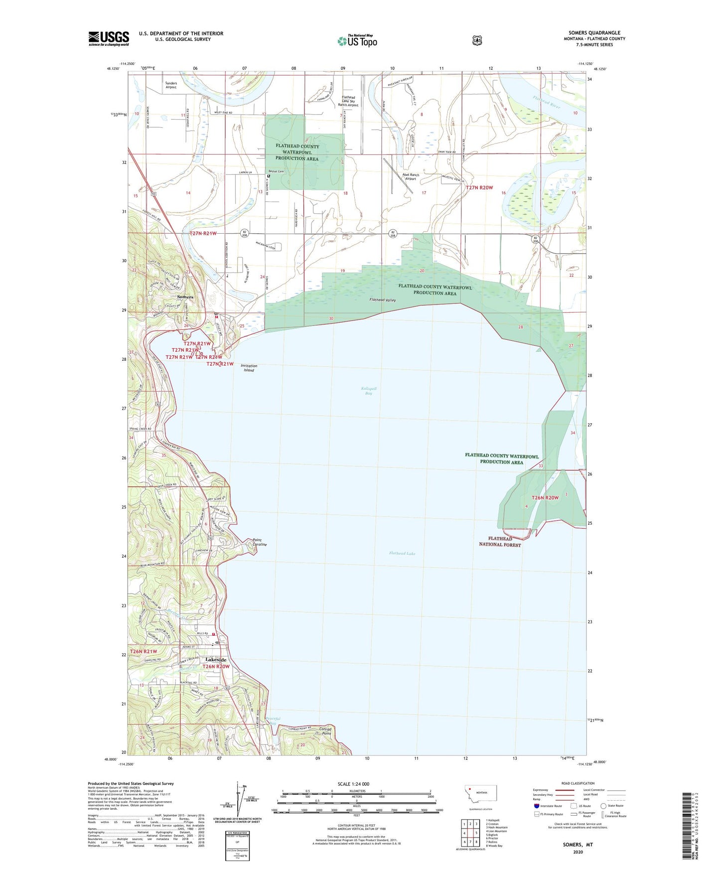
Somers Montana US Topo Map
Couldn't load pickup availability
Also explore the Somers Forest Service Topo of this same quad for updated USFS data
2024 topographic map quadrangle Somers in the state of Montana. Scale: 1:24000. Based on the newly updated USGS 7.5' US Topo map series, this map is in the following counties: Flathead. The map contains contour data, water features, and other items you are used to seeing on USGS maps, but also has updated roads and other features. This is the next generation of topographic maps. Printed on high-quality waterproof paper with UV fade-resistant inks.
Quads adjacent to this one:
West: Lion Mountain
Northwest: Kalispell
North: Creston
Northeast: Hash Mountain
East: Bigfork
Southeast: Woods Bay
South: Rollins
Southwest: Proctor
This map covers the same area as the classic USGS quad with code o48114a2.
Contains the following named places: 27N20W07BA__01 Well, 27N20W07BD__01 Well, 27N20W07DD__01 Well, 27N20W08AA__01 Well, 27N20W08AAAB01 Well, 27N20W08BA__01 Well, 27N20W08DA__01 Well, 27N20W08DD__01 Well, 27N20W09CBBC01 Well, 27N20W16AA__01 Well, 27N20W17CC__01 Well, 27N20W17DC__01 Well, 27N20W18AD__01 Well, 27N20W19AB__01 Well, 27N20W19AC__01 Well, 27N20W19BB__01 Well, 27N20W20AA__01 Well, 27N20W20AB__01 Well, 27N20W20DA__01 Well, 27N20W21AA__01 Well, 27N20W21AB__01 Well, 27N20W22BD__01 Well, 27N21W10AA__01 Well, 27N21W10DD__01 Well, 27N21W11AB__01 Well, 27N21W12AB__01 Well, 27N21W12ABCC01 Well, 27N21W12AD__01 Well, 27N21W12CA__01 Well, 27N21W12DC__01 Well, 27N21W13ACCC01 Well, 27N21W13BD__01 Well, 27N21W13CD__01 Well, 27N21W14CB__01 Well, 27N21W23AA__01 Well, 27N21W23AAAD01 Well, 27N21W23AB__01 Well, 27N21W23ADDD01 Well, 27N21W24BBCB01 Well, 27N21W24CB__01 Well, 27N21W26CC__01 Well, 27N21W26CDCC01 Well, 27N21W35DD__01 Well, 59932, Abel Ranch Airport, Ben Williams Park, Bethel Cemetery, Bierney Creek, Brodericks Landing, Chautauqua Post Office, Conrad Point, Dooleys Landing, Edgewater Resort and Campground, Eidsvold Lutheran Church, Fennon Slough, Fessendens Landing, Flathead County Waterfowl Production Area, Flathead Lake Sky Ranch Airport, Flathead Waterfowl Production Area, Invitation Island, Kalispell Air Force Station, Kalispell Bay, Lakeside, Lakeside Baptist Church, Lakeside Census Designated Place, Lakeside Community Library, Lakeside Elementary School, Lakeside Fire Station, Lakeside Post Office, Lakeside Quick Response Unit - Ambulance, Lakeside-Somers Division, Merrifields, Mountain Valley Fellowship Church, Peaceful Bay, Point Caroline, Point of Rocks, Rousselle School, Saint Annes Catholic Church, Selish Post Office, Skookum, Somers, Somers / Lakeside Fire Department - Station 52, Somers Boat Launch, Somers Census Designated Place, Somers Fishing Access Site, Somers Middle School, Somers Post Office, Somers Volunteer Fire Department, Stoner Creek, Stoners Landing, Taylor Homestead Airport, The Church of Jesus Christ of Latter Day Saints, Wileys Slough