MyTopo
Broadus Montana US Topo Map
Couldn't load pickup availability
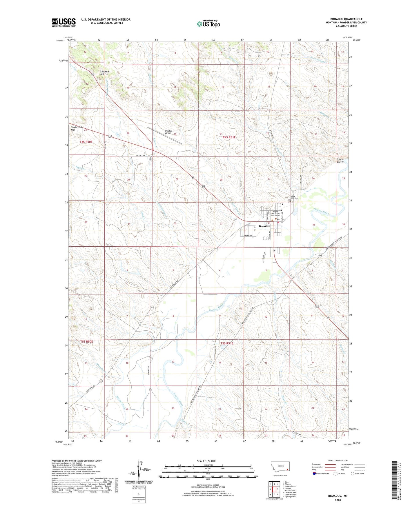
2024 topographic map quadrangle Broadus in the state of Montana. Scale: 1:24000. Based on the newly updated USGS 7.5' US Topo map series, this map is in the following counties: Powder River. The map contains contour data, water features, and other items you are used to seeing on USGS maps, but also has updated roads and other features. This is the next generation of topographic maps. Printed on high-quality waterproof paper with UV fade-resistant inks.
Quads adjacent to this one:
West: Epsie NE
Northwest: Olive
North: T Creek
Northeast: Hawkey Creek
East: Monday Creek
Southeast: Fighting Butte
South: Eldon Mountain
Southwest: Lonesome Peak
This map covers the same area as the classic USGS quad with code o45105d4.
Contains the following named places: 04S50E13DAAA01 Well, 04S51E18BC__01 Well, 04S51E19ACAB01 Well, 04S51E19BCCC01 Well, 04S51E26AADB01 Well, 04S51E28BCCA01 Well, 04S51E29ABCC01 Well, 04S51E30BDDA01 Well, 04S51E32DA__01 Well, 04S51E33ADCD01 Well, 04S51E33ADDC01 Well, 04S51E34ABA_01 Well, 04S51E34ABAD01 Well, 04S51E34ACA_01 Well, 04S51E34ACDB01 Well, 04S51E34BAC_01 Well, 05S51E02ABCB01 Well, 05S51E02CBBC01 Well, 05S51E03AACB01 Well, 05S51E03ABBA01 Well, 05S51E03ADC_01 Well, 05S51E03ADD_01 Well, 05S51E03ADD_02 Well, 05S51E05DCBD01 Well, 05S51E07CDAC01 Well, 05S51E08AB__01 Well, 05S51E08CCAA01 Well, 05S51E09CDD_01 Well, 05S51E10ABAB01 Well, 05S51E11AC__01 Well, 05S51E16BAAA01 Well, 05S51E16BBCC01 Well, 05S51E16BCBC01 Well, 05S51E16BCD_01 Well, 05S51E17BCCB01 Well, 05S51E17DDCB01 Well, 05S51E18BDBD01 Well, 05S51E19BDCC01 Well, 05S51E19CAAB01 Well, 05S51E19CACA01 Well, 05S51E19CDAC01 Well, 05S51E19DCBC01 Well, Big Sky Country Historical Marker, Broadus, Broadus Airport, Broadus Bridge Fishing Access Site, Broadus Post Office, Broadus Rest Area, Broadus Volunteer Fire Department, Coyote Creek, Doyle Creek, Fivemile Hill, Henry A Malley Memorial Library, Jesse Ambulance Service, Lone Tree Creek, Macs Museum, North Fork Sand Creek, Phillipi Creek, Post Creek, Powder River County Sheriff's Office, Powder River Historical Museum, Prairie Creek, Preston Buttes, Randall Ditch, Sand Creek, Schaffer Number 1 Dam, Southeastern Montana Historical Marker, Swede Creek, Third Creek, Town and Country Trailer Park, Town of Broadus, Valley View Cemetery, Wayside Mobile / RV Park, Wildlife Museum, Wrangler Creek