MyTopo
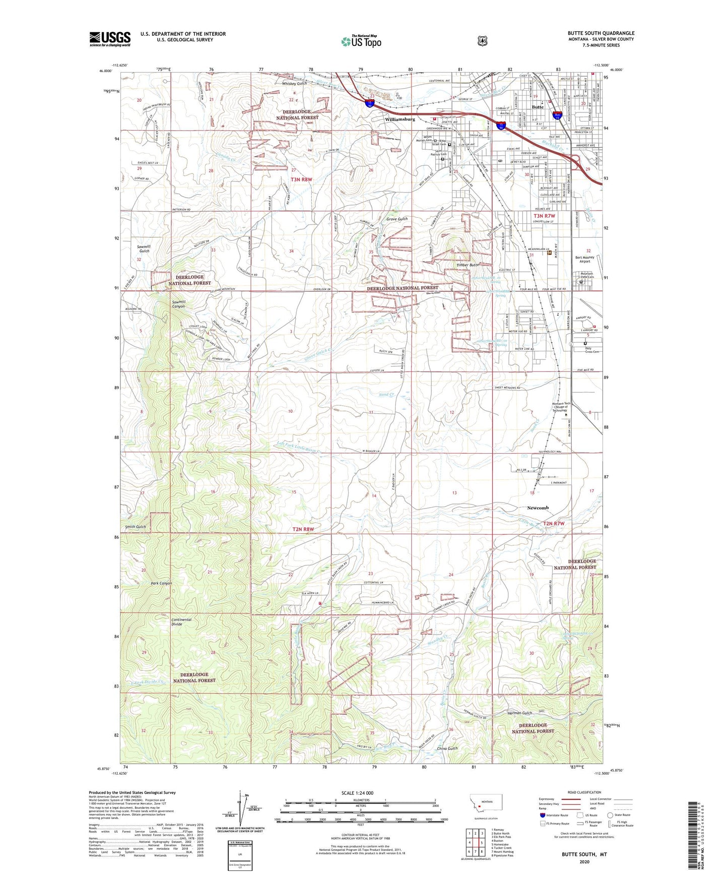
Butte South Montana US Topo Map
Couldn't load pickup availability
Also explore the Butte South Forest Service Topo of this same quad for updated USFS data
2024 topographic map quadrangle Butte South in the state of Montana. Scale: 1:24000. Based on the newly updated USGS 7.5' US Topo map series, this map is in the following counties: Silver Bow. The map contains contour data, water features, and other items you are used to seeing on USGS maps, but also has updated roads and other features. This is the next generation of topographic maps. Printed on high-quality waterproof paper with UV fade-resistant inks.
Quads adjacent to this one:
West: Buxton
Northwest: Ramsay
North: Butte North
Northeast: Elk Park Pass
East: Homestake
Southeast: Pipestone Pass
South: Mount Humbug
Southwest: Tucker Creek
This map covers the same area as the classic USGS quad with code o45112h5.
Contains the following named places: 02N07W06AAB_01 Well, 02N07W06AAC_02 Well, 02N07W06ADC_01 Well, 02N07W06BBB_01 Spring, 02N07W06BDD_01 Well, 02N07W06CBD_01 Spring, 02N07W06DBA_01 Well, 02N07W06DBA_02 Well, 02N07W06DBA_03 Well, 02N07W08CAB_01 Well, 02N07W08CAB_02 Well, 02N07W08CAC_03 Well, 02N07W17CCB_01 Well, 02N07W30ADA_01 Spring, 03N07W30BCB_01 Well, 03N07W30CDD_01 Well, 03N07W31AAA_01 Well, 03N07W31ABB_02 Well, 03N07W31ABC_01 Well, 03N07W31ABD_01 Well, 03N07W31ABD_02 Well, 03N07W31BAC_01 Well, 03N07W31CB__01 Well, 03N07W31CCB_01 Spring, 03N07W31DAC_01 Well, 03N07W32BBA_01 Well, 03N07W32BDB_01 Well, 03N07W32CCA_01 Well, 03N08W23BDC_01 Well, 03N08W24CCC_01 Well, A - 1 Ambulance, Acadia Montana, Aldersgate United Methodist Church, Alloy, Basin Creek, Bert Mooney Airport, Bert Mooney Airport Fire Department, Blacktail Creek, BLM Butte District Office, B'Nai Israel Cemetery, Boulevard Volunteer Fire Department, Butte, Butte - Silver Bow Fire Department Station 2, Butte - Silver Bow Fire Department Training Center, Butte Ardsley Mine, Butte Assembly of God Church, Butte Christian School, Butte Division, Butte Gun Club, Butte Industrial Park, Butte KOA Kampground, Butte Plaza Mall, Butte Post Office, Butte Ranger District, Butte Silver Bow Primary Health Care Clinic, Butte Skeet Club, Butte Ski Club, Camp Castlerock, Canadian Mine, China Gulch, Church of Christ, Clark Park, Colorado Junction, Copper City I Mine, Emerson School, Express Care, Family Planning and Well Child Clinic, Family Worship Center, Father Sheehan Park, Fellowship Baptist Church, First Church of the Nazarene, Floral Park Baptist Church, Flying Arrow Ranch Airport, Gloria Dei Lutheran Church, Grove Gulch, Grove Gulch Creek, Grove Gulch Dam, Herman Gulch, Highland View Baptist Church, Highland View Golf Course, Holy Cross Cemetery, KBOW-AM (Butte), Kingdom Hall of Jehovahs Witnesses, La Rue Mountain View RV Park, Left Fork Little Basin Creek, Little Basin Creek, Little Basin Creek Volunteer Fire Department, Longfellow School, Margaret Leary School, Montana Highway Patrol District III Office, Montana Tech - College of Technology, Mount Moriah Cemetery, Mountain View Cemetery, NE SE Section 4 Mine, NE SW Section 22 Mine, Newcomb, Pentecostal Church, Race Track Volunteer Fire Department, Rocker Water Supply, Rocky Mountain Childrens Clinic, Rocky Mountain Clinic, Rocky Mountain Eye Center, Roosevelt Campground, Saint Ann's Catholic Church, Saint John's Catholic Church, Saint Patrick Cemetery, Sand Creek, Sawmill Canyon, Silver Queen Mine, Smith Field, Standby Creek, Stodden Park, Tamarack Square, Timber Butte, Two-Bit Creek, Webster-Garfield School, Welker Chiropractic Clinic, Whiskey Gulch, Williamsburg