MyTopo
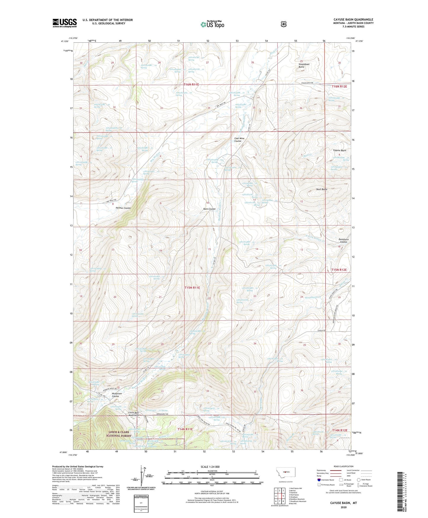
Cayuse Basin Montana US Topo Map
Couldn't load pickup availability
Also explore the Cayuse Basin Forest Service Topo of this same quad for updated USFS data
2024 topographic map quadrangle Cayuse Basin in the state of Montana. Scale: 1:24000. Based on the newly updated USGS 7.5' US Topo map series, this map is in the following counties: Judith Basin. The map contains contour data, water features, and other items you are used to seeing on USGS maps, but also has updated roads and other features. This is the next generation of topographic maps. Printed on high-quality waterproof paper with UV fade-resistant inks.
Quads adjacent to this one:
West: Wolf Butte
Northwest: Wolf Butte NW
North: Merino
Northeast: Stanford
East: Windham
Southeast: Red Hill
South: Woodhurst Mountain
Southwest: Bandbox Mountain
This map covers the same area as the classic USGS quad with code o47110a3.
Contains the following named places: 14N11E01AC__01 Spring, 14N11E02BC__01 Spring, 14N11E02CB__01 Spring, 14N11E02CB__02 Spring, 14N11E03AB__01 Spring, 14N11E03BB__01 Well, 14N11E04CA__01 Spring, 14N11E04CB__01 Spring, 14N11E05AD__01 Spring, 14N11E05AD__02 Spring, 14N11E05DA__01 Spring, 14N12E06BC__01 Spring, 15N11E03DA__01 Spring, 15N11E03DB__01 Well, 15N11E03DB__02 Spring, 15N11E04AA__01 Well, 15N11E04BC__01 Spring, 15N11E04CC__01 Spring, 15N11E05BB__01 Spring, 15N11E05BC__01 Spring, 15N11E05DD__01 Spring, 15N11E06DB__01 Spring, 15N11E08BD__01 Well, 15N11E11AC__01 Spring, 15N11E11AC__02 Spring, 15N11E11AC__03 Spring, 15N11E11BA__01 Spring, 15N11E14BD__01 Spring, 15N11E14DD__01 Spring, 15N11E18DD__01 Well, 15N11E18DD__02 Spring, 15N11E20DD__01 Spring, 15N11E21BA__01 Spring, 15N11E23BD__01 Spring, 15N11E23CB__01 Spring, 15N11E25CC__01 Spring, 15N11E27BB__01 Spring, 15N11E28CB__01 Spring, 15N11E28CC__01 Spring, 15N11E28DA__01 Spring, 15N11E28DC__01 Spring, 15N11E31DA__01 Spring, 15N11E32BC__01 Spring, 15N11E32CA__01 Well, 15N11E32DC__01 Spring, 15N11E33CC__01 Spring, 15N11E34CD__01 Spring, 15N12E06CC__01 Spring, 15N12E18CD__01 Well, 15N12E30CC__01 Spring, 15N12E31BA__01 Spring, 16N11E25BD__01 Well, 16N11E25C___01 Well, 16N11E25DCBC01 Well, 16N11E26DC__01 Well, 16N11E27BC__01 Spring, 16N11E27CB__01 Spring, 16N11E28AD__01 Spring, 16N11E28BC__01 Spring, 16N11E32BC__01 Spring, 16N11E32CD__01 Spring, 16N11E33AA__01 Spring, 16N11E35____01 Well, 16N11E35BB__01 Spring, 16N11E35BC__01 Spring, 16N11E35BD__01 Well, 16N11E35BD__02 Well, 16N11E36BA__01 Well, 16N12E31____01 Well, 16N12E31AC__01 Spring, 16N12E31AC__02 Well, 16N12E31BB__01 Spring, 59479, Cayuse Basin, Coal Mine Coulee, Dry Wolf Creek, Dunsmore Coulee, Holmes Coulee, Judith Basin County, Nickerson Coulee, Running Wolf Creek, Skull Butte, Steamboat Butte, Steamerville, Vann Coulee