MyTopo
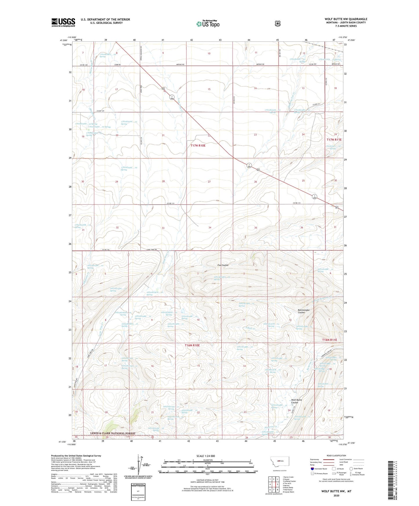
Wolf Butte NW Montana US Topo Map
Couldn't load pickup availability
Also explore the Wolf Butte NW Forest Service Topo of this same quad for updated USFS data
2024 topographic map quadrangle Wolf Butte NW in the state of Montana. Scale: 1:24000. Based on the newly updated USGS 7.5' US Topo map series, this map is in the following counties: Judith Basin. The map contains contour data, water features, and other items you are used to seeing on USGS maps, but also has updated roads and other features. This is the next generation of topographic maps. Printed on high-quality waterproof paper with UV fade-resistant inks.
Quads adjacent to this one:
West: The Arch
Northwest: Byrne Creek
North: Geyser
Northeast: Leiberg Coulee
East: Merino
Southeast: Cayuse Basin
South: Wolf Butte
Southwest: Mixes Baldy
This map covers the same area as the classic USGS quad with code o47110b4.
Contains the following named places: 16N10E03DA__01 Spring, 16N10E04CD__01 Spring, 16N10E05AA__01 Well, 16N10E05AABA01 Well, 16N10E05BC__01 Spring, 16N10E05BC__02 Well, 16N10E05DC__01 Spring, 16N10E08AD__01 Spring, 16N10E08CDAA01 Well, 16N10E08DA__01 Spring, 16N10E09AD__01 Spring, 16N10E09BC__01 Spring, 16N10E09DA__01 Spring, 16N10E10BC__01 Spring, 16N10E11BA__01 Spring, 16N10E12CB__01 Spring, 16N10E12DB__01 Spring, 16N10E13BC__01 Spring, 16N10E13CB__01 Spring, 16N10E14BA__01 Well, 16N10E14BA__02 Spring, 16N10E17AD__01 Spring, 16N10E17AD__02 Spring, 16N10E17CB__01 Well, 16N10E18DA__01 Well, 16N10E21AD__01 Spring, 16N10E21DA__01 Spring, 16N10E21DC__01 Spring, 16N10E22BC__01 Spring, 16N10E23DD__01 Spring, 16N10E24BC__01 Spring, 16N10E24DB__01 Spring, 16N11E06BC__01 Spring, 16N11E18BA__01 Spring, 16N11E18BC__01 Spring, 16N11E18BC__02 Spring, 16N11E18CC__01 Spring, 17N10E08CC__01 Well, 17N10E08CC__02 Spring, 17N10E09DC__01 Well, 17N10E09DC__02 Well, 17N10E10DC__01 Well, 17N10E12DC__01 Spring, 17N10E13BA__01 Well, 17N10E14AB__01 Well, 17N10E14AB__02 Well, 17N10E14AB__03 Well, 17N10E15BB__01 Well, 17N10E16BB__01 Well, 17N10E16BB__02 Well, 17N10E16DDDD01 Well, 17N10E17AB__01 Well, 17N10E17AB__02 Well, 17N10E17ABAC01 Well, 17N10E17BB__01 Well, 17N10E18DC__01 Well, 17N10E19AD__01 Spring, 17N10E19AD__02 Spring, 17N10E19DA__01 Spring, 17N10E20AC__01 Spring, 17N10E20BD__01 Well, 17N10E20BD__02 Well, 17N10E20BDCC01 Well, 17N10E21AD__01 Well, 17N10E22BD__01 Well, 17N10E22CB__01 Well, 17N10E23AA__01 Spring, 17N10E23DD__01 Well, 17N10E24AB__01 Well, 17N10E24AB__02 Well, 17N10E24AB__03 Well, 17N10E24BA__01 Spring, 17N10E26ADDB01 Well, 17N10E26BB__01 Well, 17N10E27DD__01 Well, 17N10E28DC__01 Well, 17N10E29AC__01 Well, 17N10E29AC__02 Spring, 17N10E29BD__01 Well, 17N10E29CC__01 Well, 17N10E31DB__01 Spring, 17N10E32BBAB01 Well, 17N10E32DD__01 Well, 17N10E33AA__01 Well, 17N10E33AA__02 Well, 17N10E33CABB01 Well, 17N10E34BBBB01 Well, 17N10E35AB__01 Well, 17N10E35BA__01 Well, 17N10E36CB__01 Well, 17N11E07CD__01 Spring, 17N11E19CC__01 Spring, 18N10E02BD__01 Well, Alkali Creek, Geyser Rest Area, Grafton Post Office, Mining Plays Second Fiddle Historical Marker, Rattlesnake Coulee, Shannon Creek, Wolf Butte Coulee