MyTopo
Stanford Montana US Topo Map
Couldn't load pickup availability
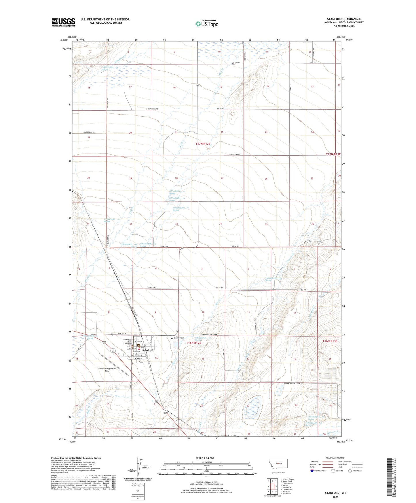
2024 topographic map quadrangle Stanford in the state of Montana. Scale: 1:24000. Based on the newly updated USGS 7.5' US Topo map series, this map is in the following counties: Judith Basin. The map contains contour data, water features, and other items you are used to seeing on USGS maps, but also has updated roads and other features. This is the next generation of topographic maps. Printed on high-quality waterproof paper with UV fade-resistant inks.
Quads adjacent to this one:
West: Merino
Northwest: Leiberg Coulee
North: Arrow Creek
Northeast: Coffee Creek
East: Stanford NE
Southeast: Benchland
South: Windham
Southwest: Cayuse Basin
This map covers the same area as the classic USGS quad with code o47110b2.
Contains the following named places: 16N12E02DD__01 Spring, 16N12E02DD__02 Well, 16N12E03BC__01 Well, 16N12E03CC__01 Well, 16N12E03CC__02 Well, 16N12E03CC__03 Well, 16N12E04BB__01 Spring, 16N12E05BA__01 Well, 16N12E07DA__01 Well, 16N12E07DA__02 Well, 16N12E07DDB_02 Well, 16N12E08AB__01 Well, 16N12E08AD__01 Well, 16N12E08CDDD01 Well, 16N12E08CDDD02 Well, 16N12E08DACD01 Well, 16N12E08DC__01 Well, 16N12E09CD__01 Well, 16N12E09DC__01 Well, 16N12E10CD__01 Spring, 16N12E10DCCC01 Well, 16N12E11AAAD01 Well, 16N12E12BB__01 Well, 16N12E12BB__02 Well, 16N12E13AC__01 Well, 16N12E13CD__01 Well, 16N12E14CCCC01 Well, 16N12E14DD__01 Well, 16N12E15AB__01 Well, 16N12E15BB__01 Well, 16N12E16AA__01 Well, 16N12E16ACBD01 Well, 16N12E16BB__01 Well, 16N12E16BB__02 Well, 16N12E16BB__03 Well, 16N12E16BB__04 Well, 16N12E16BBBC01 Well, 16N12E16BBCB01 Well, 16N12E16BD__01 Well, 16N12E16BD__02 Well, 16N12E16CC__01 Well, 16N12E16CC__02 Well, 16N12E16DCAD01 Well, 16N12E17AA__01 Well, 16N12E17BB__01 Spring, 16N12E17DA__01 Well, 16N12E17DA__02 Well, 16N12E17DA__03 Well, 16N12E17DAAA01 Well, 16N12E17DAAA02 Well, 16N12E17DDAB01 Well, 16N12E21AABB01 Well, 16N12E21CB__01 Well, 16N12E22CA__01 Well, 16N12E24BB__01 Well, 16N12E24DA__01 Spring, 16N12E24DA__02 Spring, 16N12E24DD__01 Well, 16N12E29AA__01 Well, 17N12E14CD__01 Well, 17N12E14CD__02 Well, 17N12E15BA__01 Well, 17N12E15BA__02 Well, 17N12E15BA__03 Well, 17N12E17BB__01 Well, 17N12E17DC__01 Well, 17N12E17DC__02 Well, 17N12E18AA__01 Spring, 17N12E18AA__02 Well, 17N12E21AD__01 Well, 17N12E21CD__01 Well, 17N12E21DA__01 Well, 17N12E22B___01 Well, 17N12E22BB__01 Well, 17N12E23DC__01 Well, 17N12E24BB__01 Well, 17N12E24BB__02 Well, 17N12E24BB__03 Well, 17N12E27____01 Well, 17N12E27B___01 Well, 17N12E27BC__01 Well, 17N12E28BA__01 Well, 17N12E28CD__01 Spring, 17N12E28DA__01 Well, 17N12E28DA__02 Well, 17N12E29CDDA01 Well, 17N12E30DD__01 Well, 17N12E31DC__01 Well, 17N12E32AB__01 Well, 17N12E32BB__01 Well, 17N12E32BC__01 Spring, 17N12E32DB__01 Well, 17N12E32DD__01 Well, 17N12E32DD__02 Well, 17N12E32DD__03 Spring, 17N12E33AB__01 Spring, 17N12E33BA__01 Spring, 17N12E33CB__01 Well, Basin Medical Center, Calvary Community Church of Stanford, Cotton Trailer Court, Edith Nelson Trailer Court, First Presbyterian Church, General Mills Incoporated Elevator, Hall Trailer Court, J and M Trailer Court, Judith Basin County Ambulance, Judith Basin County Courthouse, Judith Basin County Free Library, Judith Basin County Museum, Judith Basin County Sheriff's Office, Lutheran Church, Saint Rose of Lima Church, Skull Creek, Stanford, Stanford Airport/Biggerstaff Field, Stanford Baptist Church, Stanford Cemetery, Stanford City Park, Stanford Division, Stanford Post Office, Stanford Public Schools, Stanford Volunteer Fire Department, Town of Stanford